Remote Sensing Researchers Request - Convention: Oil in the Sundarbans is not available.(research of environmental technology and nature)
Thoughts Curves Country Chinta Oil drain Remote Sensing Sala river Sundarbans Satellite All ages
This article is basically a description of almost null and vigorous use of limited resources of friend of mine, a young remote sensing researcher, about the Sundarbans oil. We want to see who works with better quality satellite data than we can be encouraged by them.
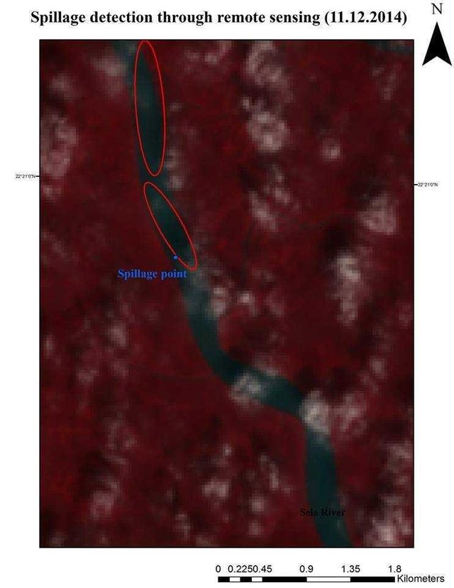
When I got the news of oil discharges in the Salala river on 9th December, I was sitting very badly for a few days. After that, on Facebook I saw Ahmed Tahmid, a student of Chittagong University's oceanography, a three-dimensional picture of topography of the hills of BandarbanHas given Depending on the height or the height, different colors are also available in the film. After commenting down the photo, I saw the image using the power information from Astor Satellite. I asked him if he could provide latitude and longitude, would he be able to prepare the pictures of any place like this? He will try and try. Then I gave him the latitude and longitude (89 ° 40'12.44 ", Pu, 22 ° 21'14" U) to the place where he did not take oil in the Sundarbans. My purpose was to make sure that if we can not collect oil before and afterwards, then an image analyst should request the programmer to write a program that will use the data to compare the differences between those pictures. Since spreading, some are spreading in some direction and at some places they are spreading less. What would be the advantage if we knew it well? In that case we can choose machinery and manpower where the situation is worse. Since the depth of my knowledge in the remote sensing was equal to the depth of the common sensation of shipping minister Shahjahan Khan, I did not know whether it was a realistic hope. Despite the last few days of efforts I still do not know whether it is realistic or not. That is why writing this to create interest in the Bangladeshi researchers who work in home or abroad with remote sensing.
Tahameed did not know what he got till now that we are worried about some of his features. Tahmidi wrote the information for me. Each photo is made of him. I do not know how I did it, just as Shahjahan Khan did not even know.
Flora and fauna, geographical location: 89 ° 34'Extreme -89 ° 40'Extreme latitude and 22 ° 00'North longitude-22 ° 24'-North Longitude, Sundarbans is one of the major components of ecology. There are not only numerous reptiles, dolphins, deer species, but also numerous species of mussels and snail species (Bivalve & Mollusc) which are the primary food category of the whole ecosystem and one of the major producers. There are also numerous diverse crab and soils of the Benthic Organisms, which play the most important role in starting the dynamics of the soil and feed chain of the entire ecosystem.
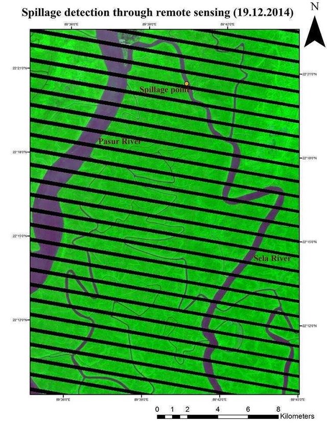
A total of 3,58,000 liters of furnace oil spread across the entire river-pus river in the recent Old Tanker Southern Star 7 tragedy in the Salala river. The most damaged Sundarbans' aquatic ecosystems and food chains due to this oil spill. The following figure shows the most affected areas of oil spill points and the surroundings of the canal and the surrounding area, spreading the surrounding oils. The photos are made from Astor Satellite Data.
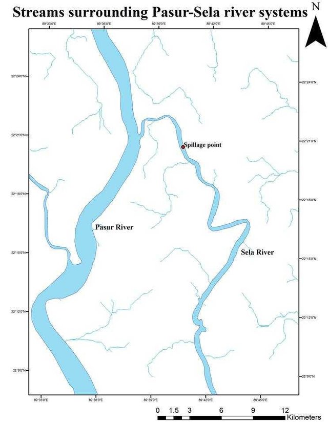
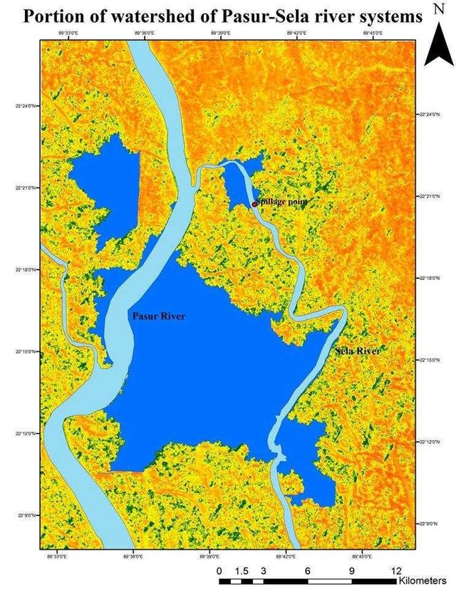
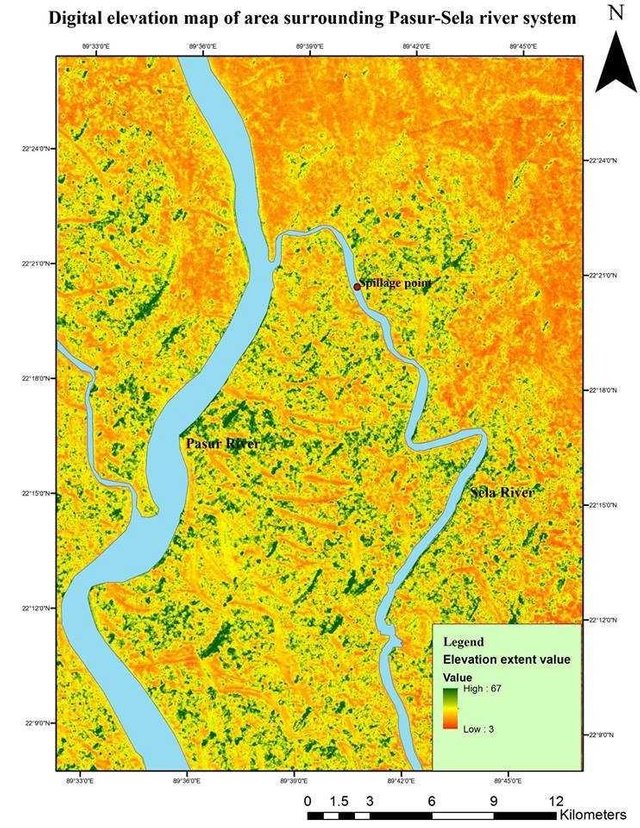
The next image is basically the main watershed area, which is mainly dependent on the river waters, which are dependent on the rivers. Its next image is the Digital Elevation Map (DEM) of the area surrounding Sheila Pusu river, which we see in the area of the sea, the maximum height is 67 cm.
On the Salah river there are Chila Unions of Mongla upazila of Bagerhat district which are famous for exportable shrimp and crabs and the residents of the union are essentially dependent on the river water resources for the production of this water. And about 16% of the people of this region get water from the river Shalya-animal. Due to the high prevalence, this large amount of oil has taken very little time to propagate and this oil is not only transmitting saline and animal water, but also the neighboring Sibsa river.
In a word, due to the oil spill on December 9, 2014, only the biodiversity of the Sundarbans and the livelihood of agricultural and fishery people is not at stake in the surrounding ecosystem.
Now I can go back and forth with limited resources, what has been done so far.
9 Date did not take oil. On 11th, a satellite image was dropped from LandsSat, so that two big spots were marked. The idea is that oil float level. The original image was quite unclear due to the cloud, so he had to process. I did not understand with white eyes.
So what do we need now? If we find the pictures on 10, 12, 13, we may write down the program and find out the oil in the next few days. The news is in the country of Tahmeed, still students are so dependent on satellite imagery found in money. We can not get the problem of these pictures found in the money. When they will benefit them. Tahmeed gets 9 days later. The previous picture on it is Corrupted on the 3rd date. They get another set of information on 20th. But in the meantime we will lose a lot of information. Below are free pictures available from Landset 7.
Bin Paisa does not get a better resolution picture. The explorer and environmental activist Tanim Ashraf saw the thin layer of oil in the previous day . We can not understand the quality pictures that we have. It would be very good to know if someone could tell it from a better quality picture.
Those who work on remote sensing outside the country and get better and often satellite pictures, can they see if something can be done?
Congratulations @obdataraf88! You have completed the following achievement on Steemit and have been rewarded with new badge(s) :
Click on the badge to view your Board of Honor.
If you no longer want to receive notifications, reply to this comment with the word
STOPTo support your work, I also upvoted your post!
Congratulations @obdataraf88! You have completed the following achievement on the Steem blockchain and have been rewarded with new badge(s) :
Click on the badge to view your Board of Honor.
If you no longer want to receive notifications, reply to this comment with the word
STOPDo not miss the last post from @steemitboard:
Congratulations @obdataraf88! You have completed the following achievement on the Steem blockchain and have been rewarded with new badge(s) :
Click on the badge to view your Board of Honor.
If you no longer want to receive notifications, reply to this comment with the word
STOPCongratulations @obdataraf88! You received a personal award!
You can view your badges on your Steem Board and compare to others on the Steem Ranking
Do not miss the last post from @steemitboard:
Vote for @Steemitboard as a witness to get one more award and increased upvotes!
Congratulations @obdataraf88! You received a personal award!
You can view your badges on your Steem Board and compare to others on the Steem Ranking
Do not miss the last post from @steemitboard:
Vote for @Steemitboard as a witness to get one more award and increased upvotes!