My Faults: A Journey Along the Pacific and North American Plates, Part 1 of 3 (Alaska to Haida Gwaii)
Looking at a large map, most earthquake faults make sense. They are the boundaries between continent blocks, nature’s version of borders. They are cracks between the big plates beneath our feet, tectonic plates that move endlessly over the molten core of the earth. Where these plates collide, slip, and slide beneath one another, we get seismic activity like earthquakes and volcanoes. Even in the middle of plates, where there are thin spots in the earth’s crust, events can occur. But most big seismic action happens along the periphery where plates come together.
Over the last 10 years or so, I’ve become fascinated by this geology. If I’m honest, then “worried” might be a better word, since I live in earthquake country. But while I think about earthquakes, that concern doesn’t keep me up at night. My pre-occupation centers more on how to be prepared as well as possible, not if but WHEN the next big one comes. Also, I really enjoy the geography of it all.
Since I’m based on the west coast of the United States, my main interest is the northeastern boundary of the Pacific Plate, where it scrapes up against the North American Plate. From Alaska and the Pacific Northwest through California and into Mexico, I have a great passion for the west coast of North America, the region that I call home.
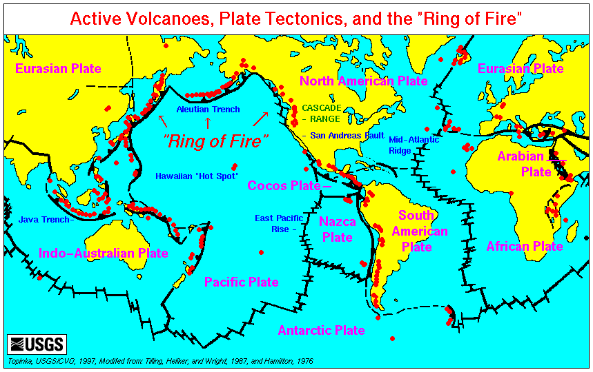
In the world of disclaimers, I’m not a geologist or seismologist, so my understanding of these disciplines is amateur at best. And I certainly do not understand regions beyond this one very well, so I’ll let others write about those. This is my attempt to trace that a long set of fault lines down the map, discussing what I understand about its various parts. This line also forms part of the Pacific Ring of Fire, the plate perimeter where seismic activity often occurs through earthquakes and volcanoes.
At the Top of the Ring of Fire
The line between the Pacific and North American Plates begins at the top of the eastern Pacific Ocean, traced by Alaska’s Aleutian Islands. From the Bering Strait that separates Asia from North America, we could turn west. That would take us towards Siberia and down the Kamchatka peninsula, which looks very much like Alaska, down the Kuriles and into Japan. But instead, we’ll go east from the Bering Strait, tracing the Aleutian island chain towards Alaska proper and following the coastline as it curves to the southeast, beginning to mark the west coast of North America.
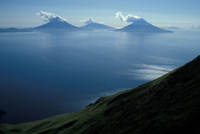
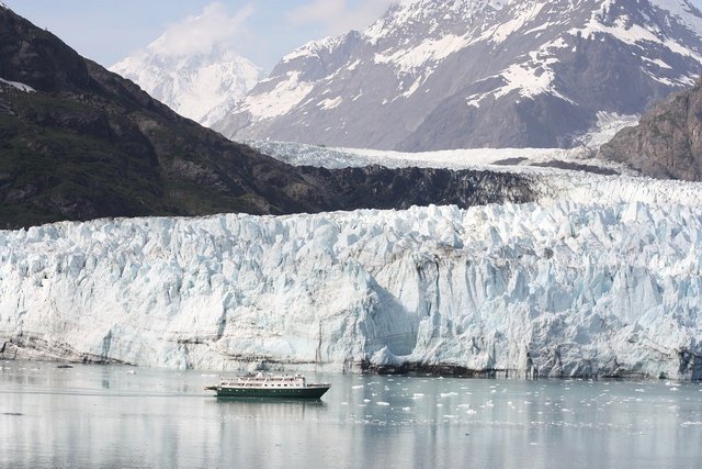
The image above (at the top of this post) shows some of the Aleutian islands; they include 41 volcanoes, more than half of them active.
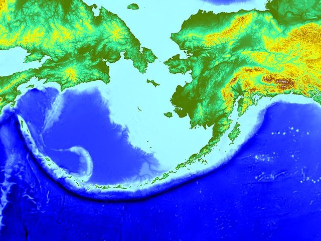
The first, top section of this boundary is called the Aleutian subduction zone (fault). It’s scary as hell because it’s a subduction zone, the same kind that has produced mega-earthquakes and tsunamis off the coasts of Japan and Sumatra. In 1964, this fault segment was jolted by an earthquake centered in the area of Prince William Sound. The Good Friday quake, as it was called later, was one of the most powerful earth movements ever recorded (measuring 9.2 on the Richter scale). It sent tsunamis all over the Pacific: to Japan, Papua New Guinea, New Zealand, various islands, Mexico, Peru, and even as far down as Antarctica.
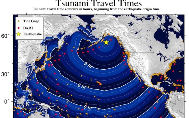
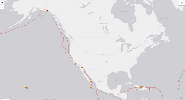
Here is a U.S. government model of tsunami arrival times around the North Pacific, following a hypothetical major earthquake on the Aleutian fault:
In the last 75 years, this fault has produced four earthquakes of 8.0 or greater intensity, which is quite severe. Because it’s a good distance from most population centers around the Pacific, there should be ample warning for people on distant shores to avoid the beaches and run for high ground after a tsunami-producing quake in the Aleutian zone. However, Alaska’s largest city of Anchorage, just to the north of the fault line, has several hundred thousand residents who are at risk from a large quake on the eastern side of the fault.
Tracing that line further east, it begins to curve downwards along the coast of Alaska. There is a transition zone as it turns southeast, which is a source of some strong seismic activity in its own right as these plates push into and beneath one another. Then the Fairweather-Queen Charlotte Fault takes the plate boundary down past the coasts of southeastern Alaska and British Columbia, Canada. The Alaskan section is known as the Fairweather fault and it runs through Glacier Bay, where giant cliffs of ice calve and crash into the water even without any help from tectonics.
Queen Charlotte and Haida Gwaii
On the Canadian side, this fault takes on the name Queen Charlotte. The islands along this coast once had that name also. While some residents still call them “the Charlottes”, they are now known more officially as Haida Gwaii, their native name. The Queen Charlotte fault is oriented much like California’s San Andreas fault, which has strike-slip movement as the plates move there horizontally. However, in the 2012 Haida Gwaii earthquake (7.9 magnitude), a seafloor map showed that the quake included a thrust component and was more like what scientists would expect along the Cascadia fault to the south. Some of nature’s mysteries are still being revealed to science.
If you are travelling south by boat through Queen Charlotte Sound, there is a big gap between the Haida Gwaii archipelago and Vancouver Island to the south. Deep ocean swells rock the boat through this strait until you get into the lee of Vancouver Island. Smaller boats can head in to the main coastline and seek the shelter of smaller islands that line it; thread those needles and you can travel up or down much of the coast that way.
This gap in the ocean is also the approximate home of the Queen Charlotte triple junction, a place where three faults come together. The Fairweather-Queen Charlotte Fault ends, joined by the Explorer Ridge and the Cascadia Subduction zone. It is a junction that has produced some strong seismic activity in the past and promises more in the future.
This was Part 1 of 3. Please continue reading when the next segment is published!
References for all three parts. All images are public domain or produced by a U.S. government agency and not subject to copyright:
Winchester, Simon. A Crack in the Edge of the World: America and the Great California Earthquake of 1906 (HarperCollins 2013)
https://en.wikipedia.org/wiki/Aleutian_subduction_zone
https://en.wikipedia.org/wiki/1964_Alaska_earthquake
https://en.wikipedia.org/wiki/Cascadia_subduction_zone
https://en.wikipedia.org/wiki/Cascade_Range
https://www.newyorker.com/magazine/2015/07/20/the-really-big-one
https://www.opb.org/news/series/unprepared/jan-26-1700-how-scientists-know-when-the-last-big-earthquake-happened-here/
https://en.wikipedia.org/wiki/2012_Haida_Gwaii_earthquake
https://en.wikipedia.org/wiki/1700_Cascadia_earthquake
https://en.wikipedia.org/wiki/Mendocino_Triple_Junction
https://en.wikipedia.org/wiki/San_Andreas_Fault
https://en.wikipedia.org/wiki/1989_Loma_Prieta_earthquake
https://en.wikipedia.org/wiki/1994_Northridge_earthquake
https://en.wikipedia.org/wiki/1857_Fort_Tejon_earthquake
https://en.wikipedia.org/wiki/1986_North_Palm_Springs_earthquake
https://en.wikipedia.org/wiki/Brawley_Seismic_Zone
https://en.wikipedia.org/wiki/Salton_Trough
When I read this article, I remembered several of earthquakes that occurred in Indonesia with high magnitude, up to 7.2 on the Richter scale. The victim is up to 2,000 more, it is only in Palu, Central Sulawesi. Previously the earthquake also occurred in Lombok, West Nusa Tenggara.
Until 1960 the earth was considered static by scientists because at that time there were no strong opinions. Then Sir Charles Lyell, a geologist, confirmed and perfected the principle of "uniformity" Hutton in his book Principles of Geology. Lyell states that the most dramatic geological appearances can be explained by gradual changes over long periods of time - for example by periodic tectonic activity and volcanic eruptions.
The earth was once a so-called continent without continent as it is now known. Earthquake and Tsunami Disasters that occur in several regions, contain shifts in the earth. Geologists say, there is a possibility that the earth will become one again as before. Maybe hundreds of years to come. I don't know, we don't live at that time.
You have some very strong ones, being right near a dangerous subduction fault. Stay safe!
That's right, Tom. Very sad when realizing the awareness of disaster mitigation of Indonesian people are still low.
Living inside the ring of fire is sometimes nice because of the hot springs @donkeypong
Earthquakes are no joke! I remember always watching the devastation they cause in the US and Asia on TV.
Fortunately for us, Nigeria has never experienced any severe or even close to worrisome earthquake .
Heck its not something we think can happen. Tsunamis dont occur here too, likewise tornados or hurricanes or wildfires .
Its bizarre , but Godgiven.
Funny thing , I wanted to study geology in uni and was very good in geography and its related courses .
Topics about the earth still freaks me....
Thanks for this tom🌎
west coast... I wouldn't be surprised if you was in California ...
It's a fascinating subject. Glad you enjoy it also.
Friend, how are you? good writing, did you take your time to study this topic? It is interesting to know about this, recently in Venezuela there was an earthquake of 7.1 thank God there were not many disasters at least in Venezuela, but every time I see news about an earthquake or whatever it is where nature ravages me I am filled with fear , that's why it's good to learn and read a lot
It's a part of life in many places. Hopefully, there won't be destructive ones right near population centers, but in time, most places near fault lines will get hit.
The pacific plates of north america interesting trip, were you there? the truth is almost no geology but if I like to see program about these things
Although I do not live in a country where there are earthquakes or tsunamis I have a government that is like an earthquake hahaha so that takes away the sleep of anyone
Now this is good, it shows you the origin of those disasters and because they happen, I've also seen movies about them, but these are faults that come with the world
Oh, those tectonic governments don't make it easy either!
Hi how are you? I like the geology but I do not know much but there is a channel on TV where they pass over these faults that there are in the world I have seen as there is more in Canada, the United States are the places that I see frequently as well as for the place of Europe unfortunately this came with the creation of the world so things happened are faults and I imagine that over time you learn to live with it
You already know how to protect yourself from an earthquake, and surely the buildings are made with special materials
Recently there was a tremor in my country, I was very much afraid of the magnitude but if it felt strongly in almost the whole country we are not prepared for these things
Probably none of us are as prepared as we should be for natural disasters, but we should try to do the best we can to be ready for the ones most likely to hit our areas.
Earthquakes are scary stuff! I'm not a fan of watching those "end of the world" movies because they just end up making my worry about it. I try to just prepare as well as I can and then hope that nothing happens. It probably will eventually, but at least I'll be prepared.
I didn't think much about how the happenings at the northern end of the pacific plate would be affecting all throughout the Pacific. That's crazy there's only a 3 hour delay between earthquake in the Aleutians and tsunami in Seattle. Or 5 hours to LA and Hawaii!
There are people who spend their whole lives worrying and prepping for things. That's clearly excessive. However, complacency and denial are not going to serve anyone well either in the event of a disaster. Somewhere in between, we need to be aware of and prepared for likely events without spending our lives worrying about them.
Yes, there's a difference between planning/preparing and obsessing/fixating. The first two will allow you to live a more peaceful life now *and later. The latter will keep you in fear and difficulty even when the calamity happens. It's important to have a balance.
Looking forward to the rest of your series!
I have been living in the Vancouver region for 2 years, and I remember only two small earthquakes. In October 2012, I may have been away, as I don't remember the 2012 Haida Gwaii earthquake.
It's been very quiet for a long time there. But please stay tuned for Part 2 of this post, which will focus on that segment of the fault lines. :)
I live Sir @donkeypong in the Philippines and we are in the Ring of Fire. But the homes here can last earthquakes and schools are also taking earthquake drills just to prepare when the big one comes.
It's good to be prepared!
It is an interesting subject to be fair and being on the west coast of the United States I can see where the interest stems from. I'm luck enough to come from a country that has never had any issues with earthquakes and hopefully never will. Our lovely Island just has to worry about Hurricanes and massive flooding, nothing serious.
I'm always open to learning about new things which is why steemit appeals to me so much as there are people here with knowledge that i don't have and would like to know. Not earthquakes nessessarily but any subject written in depth like this will always catch my interest. I know your not a professional but you have given a detailed analysis of the concept with your post. I've noticed a large amount of natural disasters in recent times and am just wondering if this is increasing or is it just a by product of the digital age that more of them are in our focus line with smart phones and international news???
Thanks for the comment. I think both are true; we're seeing more damage from disasters and it's also being reported more heavily. Partly, populations have grown and people are living in places (such as in floodplains and canyons) that are prone to regular flooding and fires, etc., which might have not been a big deal if they swept through a generation or two earlier when there weren't homes there.