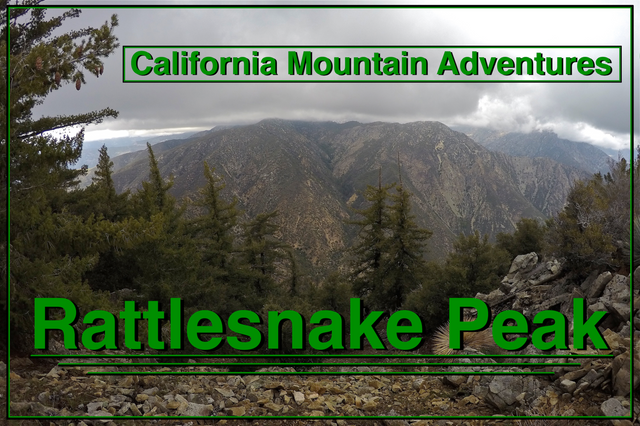
California Mountain Adventures - Rattlesnake Peak
Welcome to this edition of
California Mountain Adventures!!
In this adventure some friends and I climb up and camp on top of
Rattlesnake Peak!
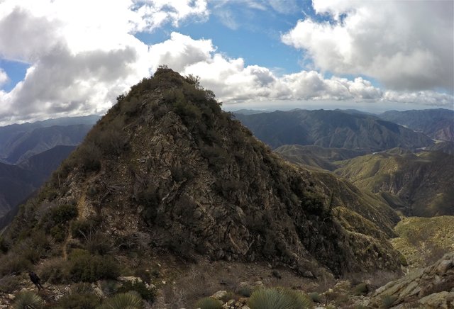
Rattlesnake Peak is a 5826 ft (1776 m) peak in the San Gabriel Mountains in Southern California. This hike was a loop beginning and ending at the Shoemaker road trailhead going up the southeast ridge and down the northeast ridge with an overnight stay on top of the peak!
After he got off work my buddy Alan (aka Pharraoh on Youtube) picked me up and we drove up to the trailhead and met his other buddies Matt and Ryan. We started hiking up Shoemaker road in the dark with the East fork of the San Gabriel river raging down below us. We followed the road to the cutoff for the trail to the peak. We went a short distance up the trail and then made a small detour out to a large flat area on the hill that was flattened many years ago to place some water tanks. The old tanks are still there but have long since been out of use. We setup our camp there and got some rest for the big climb to the summit the next day.
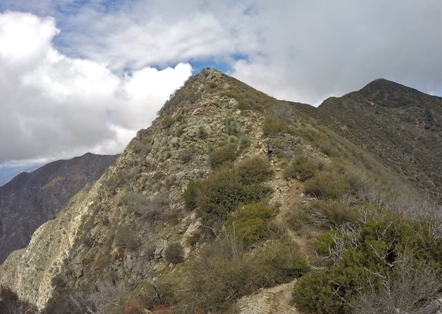
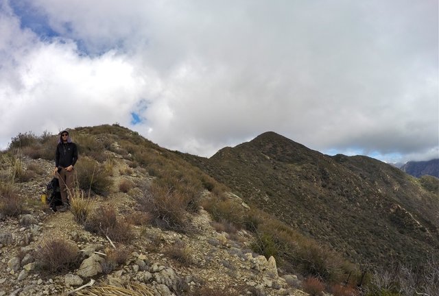
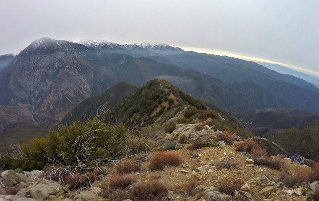
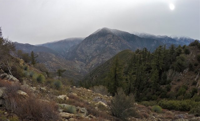
We woke up to a cold frosty morning. We made some breakfast, packed up camp, and started the big climb. The climb wasn't really technical at all, just brutally steep. Going straight up the mountain with overnight packs was a real test of endurance. We stopped to rest multiple times. The southeast ridge had great views over Graveyard canyon and Camp Williams and even out to the San Gabriel reservoir which is quite full right now! But as we climbed the clouds were building and started blocking some of our views. We watched as the clouds blew all around us. Engulfing us at times. We knew there was a chance of these clouds dropping some rain/snow, but we were hoping it wouldn't be much. We continued climbing, pushing our way up the ridge one stretch at a time.
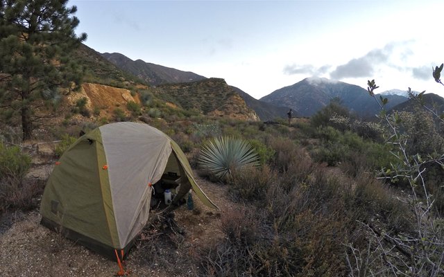
Morning time at camp
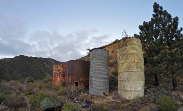
The old water tanks
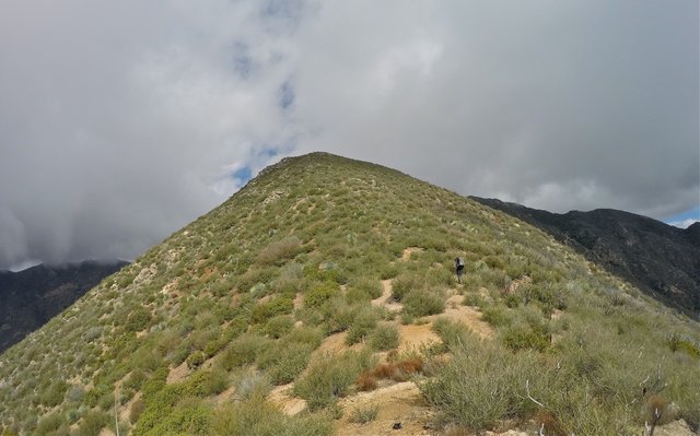
Starting to climb
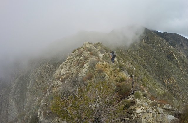
Clouds blowing across the ridge
Climbing straight up the ridge
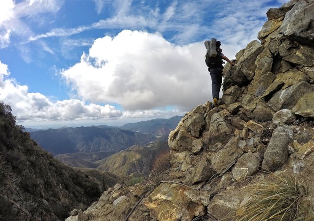
Matt making his way up some rocks
A big point along the ridge that we had to climb over
Ryan stopping for a quick break
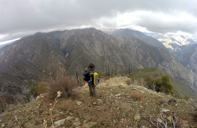
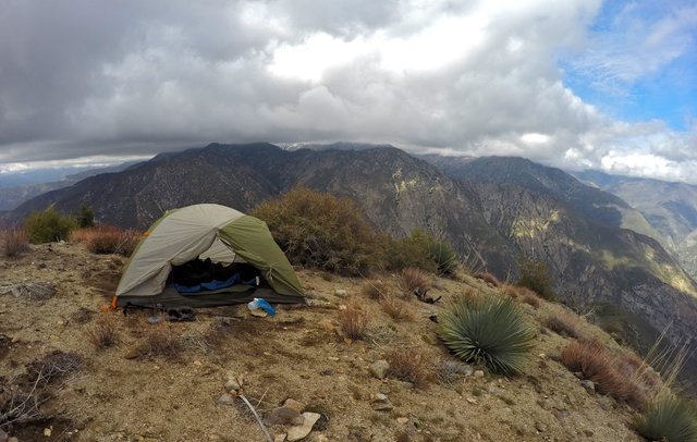
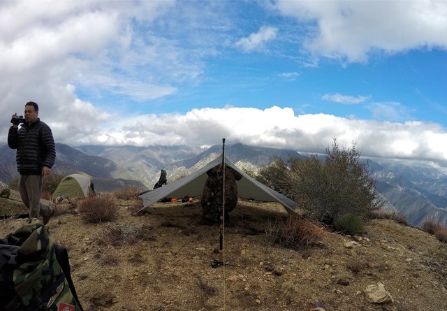
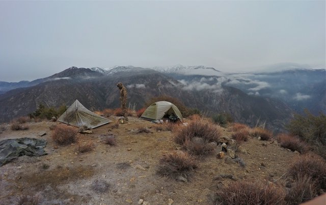
Although it was a tough climb we made good time and arrived at the summit in the early afternoon. We signed the summit register and I saw my signature in there from when I climbed it over 5 years ago. That was pretty cool to see! I had wanted to come back and camp up there ever since that day and now here I was!! We rested for a bit on the summit and then made some lunch. After lunch we took our stuff over to a nice flat area just off the north side of the peak that was perfect for us to setup camp! After getting camp all setup we relaxed and enjoyed the rest of the day watching the clouds blowing all around us. Sometimes completely engulfing us and sometimes breaking and opening up views across the canyon to Iron mountain and the Bridge to Nowhere way down below. Being in the clouds was really neat, but it was also really cold. And as the evening came the temperature dropped down below 30F(-2C)! We made our dinners (with Alan making his gourmet meal as usual) and then we got tucked into our sleeping bags early for a long cold night!

The summit register
Alan looking off the north side of the peak
Getting my tent all setup
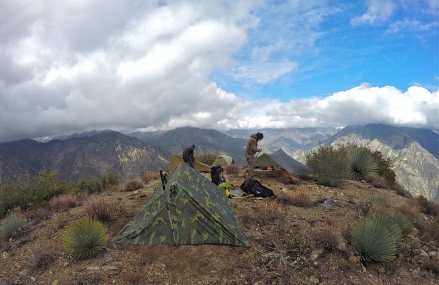
Setting up camp
Alan getting some footage for his Youtube video
and Ryan setting up his tarp shelter
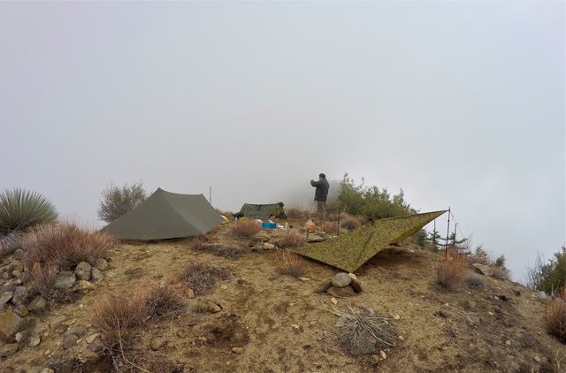
Camping in the clouds
We woke up early the next morning. Cold but happy that the rain/snow that was forecasted never came! The clouds were high in the sky and we got some great views of the snow capped peaks in the San Gabriel high country and we even saw the beginning of a beautiful sunset! But before long the clouds were back to block our view of the sunrise. We packed up camp and started out early on our descent of the northeast ridge. This route was also brutally steep! The trail was less defined than the trail on the southeast ridge but with a little route finding here and there it was pretty easy to follow. The ridge had some really great views of Iron mountain, the Bridge to Nowhere, and the East Fork. At a certain point the trail dropped us off the south side of the ridge (still brutally steep) which then eventually connected with a trail that follows along the remnants of the upper part of Shoemaker road. From here the hike flattened out (finally some relief!) and then connected with the actual road at the "Tunnels to Nowhere"! We followed the road through the two tunnels and back to the Shoemaker road trailhead where we started. Ending yet another epic California Mountain Adventure!!
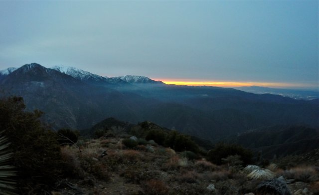
Early morning sunrise
Packing up camp
Looking down the northeast ridge
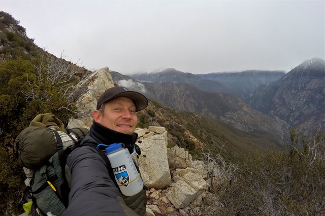
Selfie on the northeast ridge
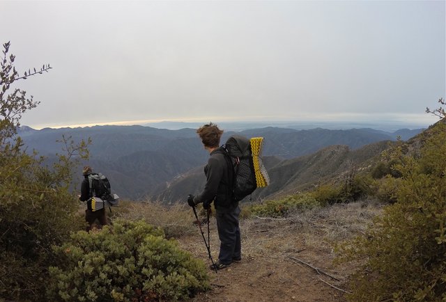
Ryan and Matt looking south from the ridge
Views looking up the East Fork
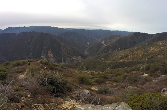
Views looking down the East Fork
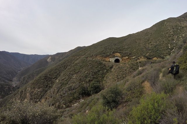
Approaching the "Tunnels to Nowhere"
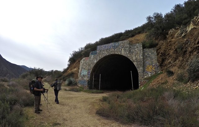
The first tunnel
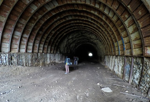
Inside the first tunnel
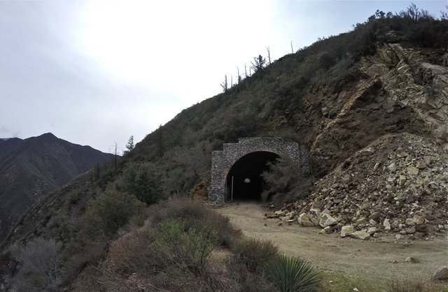
The second tunnel
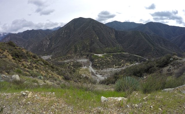
Overlooking the East Fork from Shoemaker road
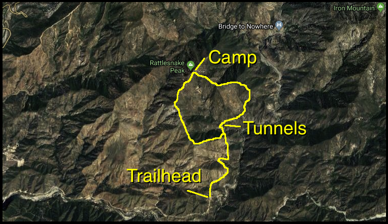
click to view map large
Be sure to check out Alan's video of our trip and subscribe to his Youtube channel to see more of his awesome adventures!!
And that's it for this California Mountain Adventure!
Steemit World Map
Contact me on Discord

#SoCalSteemit is building and supporting the Steemit community of Southern California. If you are from SoCal and are into creating quality content here on Steemit, we'd love for you to follow us @SoCalSteemit and join our group on Discord


Animation By @zord189


Very cool. I was admiring the tarp tents. As you know I use polls for hiking and the idea of using the same polls for part of the tent sounds nice and light. How did you hold up in the cold in your tent?
Ya I don't know about that tarp stuff. Those guys are lucky it didn't snow on us. They had to be FREEZING! I was good in my tent. I also brought more layers of clothing than they did. If I really wanted to go lightweight I have a "Lunar Solo" tent by Six Moon Designs that is super lightweight and uses 1 trekking pole to hold it up! At $200 it's super overpriced but I got mine used from a friend for just $30!
Dude I like that. Something like that would be perfect. Yea your friends looked cold in the video. Are they on STEEM?
The lunar solo is pretty legit if you wanna go lightweight. But you really need a ground sheet with it because the floor is just netting. I know I was cold, so I'm pretty sure they were freezing! lol. They aren't on Steem yet. I've been telling Alan about it for awhile now and he seems pretty interested. Especially now because I guess youtube hasn't been paying as well. He has a big youtube following and he used to make $500/mo on there, but he told me now it's only like $150-$200/mo. I should really try to get him to start uploading his videos to Dtube as well.
This looks like an incredible time. I've done some day hikes in the smokies, but never any overnight trips and after seeing this makes me want to. How heavy were your packs and any tips for keeping it light?
It was a blast! Our packs were pretty heavy but mostly because there is no water on the peak so we had to carry all our water for the whole trip. If you wanna keep your pack lighter camp by water. Other than that just try to only bring the necessities. You might think "this extra item doesn't weigh much I'll bring it" but then you say that for 3 or 4 other things and before you know it you've added an extra pound or two to the weight!
Holy cow what an adventure and a post just as great!!
It is shots like those that make me wish I was closer to the mountains Those tunnels to nowhere would put the perfect touch on a fantastic scenic hike and camp.
Just awesome!
Posted using Partiko iOS
Thanks @zekepickleman! I'd go crazy if I didn't live close to the mountains! lol. Going through those abandoned tunnels was a cool little bonus near the end of the trip. I was really glad we decided to take that route down.
Spectacular photos! I did my first solo wild camp a couple of weeks ago, and I'm definitely hooked. I did my first ever mountain camp last year, and it was pretty chilly too, but a fantastic challenge. The next challenge is to do a multiple day camp - hopefully soon.
I love that summit visitor's book! What a great idea. I think if we had those on our mountains in Scotland they would get sopping wet and/or stolen :/
Thanks @natubat! I saw your video of your first solo camp, that was awesome! If you're anything like me you'll love going for multiple day trips. Even just 2 nights, because you get that second day where you get to spend the whole day out there! That's the best. The summit registers here can get sopping wet or stolen too. Usually they are in a ziplock bag inside of a waterproof jar or can or box like this one. But sometimes they can leak. And there are some people that for some weird reason just don't like the peak registers and like to steal them. Luckily I don't think there's too many of those people, but I know there's a few of 'em out there.
There are some people who will steal anything! I cannot wait for those multiple day trips - when the weather gets just a bit warmer! :)
Hiya, @lizanomadsoul here, just swinging by to let you know you're being featured in today's Travel Digest #459
Your post has been manually curated by the @steemitworldmap team, and if you like what we're doing, please drop by to check out all the rest of today's great posts and consider upvoting and supporting us.
Thank you @lizanomadsoul!!
Congratulations, Your Post Has Been Added To The Steemit Worldmap!
Author link: http://steemitworldmap.com?author=derekrichardson
Post link: http://steemitworldmap.com?post=california-mountain-adventures-rattlesnake-peak
Want to have your post on the map too?
Thanks @steemitworldmap!
Wow what a great expedition!! Looks like a lot of fun, and you got some great shots as well!
Thanks for sharing!
Thanks @squishysquid! It was definitely a lot of fun.
Congratulations! Your high-quality travel content was selected by @travelfeed curator @elsaenroute and earned you a reward, in form of a 100% upvote and a resteem. Your work really stands out! Your article now has a chance to get featured under the appropriate daily topic on our TravelFeed blog.
Thank you for being part of the TravelFeed community!
Learn more about our travel project by clicking on the banner above and join our community on Discord
Thank you @elsaenroute!!
Beautiful pictures. It looks like a good day for a hike like that. I've heard of Rattlesnake Peak, but it isn't some place I had been before. I think the closest was Wrightwood. I had relatives out there.
Thanks @tryskele! Yep, it's not to far from Wrightwood.
What an incredible post, @derekrichardson ! I love all the photos so much ! Amazing * ___ * I love that sunrise shot.... aaaaah~ This is a really outstanding post, it makes me feel full with adventures :) Gorgeous narration, too :)
Made my day <3 !!!
Thanks @veryspider! The sunrise that morning was looking so beautiful. We were all getting really excited for it to rise over the mountains... but then the clouds came in and denied us our glorious sunrise!! Oh well. lol.