A Hike So Beautiful
Do you find mountain climbing interesting or if you never climbed a mountain yet and wanting to challege your self, try this guide for beginner's hike you will surely enjoy.
BASIC INFO
Name: Mt. Maculot or Mt. Macolod
Location: Cuenca, Batangas
Height: Summit (930 Masl). Rockies (706 Masl)
Difficulty: 4/9
Trail Class: 1-3
Guide: Mandatory/Required
Mt. Maculot is one of the several scenic mountains surrounding the province of Batangas and undeniably one where Taal Lake is most beautiful to be seen from. She has been a mystery to many for a very long time as talks about it being enchanted has spread quite frantically among locals instilling both fear and curiosity among visiting mountain enthusiasts. While several deaths in this mountain have been recorded in the past with the most recent dating in 2013, it remained a favorite among climbers and is still packed with lively souls every single day.
MT. MACULOT ROCKIES SUMMIT GROTTO
THE CLIMB
Due to proximity issues being based in Laguna, I decided to skip Mt. Batolusong, headed instead to Batangas for the challenge of Mt. Maculot and I was just glad I did. At first I thought of being arrogant for not considering the arduous task this mountain requires but then again I realized that it will serve me better any other way to prepare myself for the climb to Mt. Pulag which will take place in 2 weeks.
MT. MACULOT ROCKIES SUMMIT GROTTO
Anyways, there was just I and my “Boyfie” this time. We took the trail Rockies-Summit-Grotto as I was eager to experience the challenge early on. I haven’t climbed in a while and I have gained quite a few pounds from the last time I dared conquer a mountain peak so I was very aware this will be thrice as hard as the last time I was in the mountains. Although I’ve climbed Taraw Cliff in El Nido a week back, I still wasn’t very confident this is gonna be easy.
MT. MACULOT ROCKIES SUMMIT GROTTO
The climb kicked off at 7AM with a walk along the concrete Mt Maculot Rocky Road that was gradually ascending until its very end. I was sweating profusely so I was just glad to see a resting camp as we turned left off the main road. Past that is a flat trail which will stretch for 15-20 meters and will descend to what seem like a multi-tiered waterfall which at that time was empty of water. Past that. The real ordeal begins.
MT. MACULOT ROCKIES SUMMIT GROTTO
I gotta hand it over to Mt. Maculot. She’s the most difficult mountain I’ve climbed thus far. She was purely unforgiving. It’s no wonder that before reaching the campsite, mountaineers will pass through 14 resting camps as catching a breather once in a while is of immense importance. If I would have to describe Mt. Maculot, I’d say she is the kind who doesn’t beat around the bush and get straight to the point as what her trail suggest. It is like a natural ladder that goes straight up and gets steeper as the assault gets nearer the campsite with rocks and roots both protruding from the ground which were at some instance helpful but were additional challenge for the most part. Perhaps the one thing that got me going on despite the climb getting even more unbearable as we inch closer to the top is the promise of a more stunning view of Taal Lake.
MT. MACULOT ROCKIES SUMMIT GROTTO
After hours of painstaking assault, we reached the campsite at 8:45AM. We rested for a little then headed towards the infamous Rockies.
THE ROCKIES
From the campsite, we headed west for the Rockies. The trail was a straight path along overgrown grasses with the view of Taal Lake and the surrounding valley being seen all over. A quick descent got us to a spot where we got to marvel at the Rockies for the first time. A steep descent followed but was made easy by ropes installed as support along the trail until the stablest ground going to the base of the Rockies. The hike from the campsite to the base of the Rockies took us 15 minutes.
MT. MACULOT ROCKIES SUMMIT GROTTO
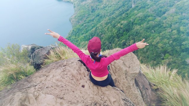
The Rockies speaks true to its name as in order to get to the top, we had to climb through boulders. The first part was the most difficult. We had to be careful not to hit our heads as we struggle to get to a safe spot. After that, everything was just a walk in the park (Kidding ^-^). There were two parts of the Rockies were you can witness Taal Lake in full view and get your death defying photos taken. We headed first to the left side of the Rockies, got some photos taken then headed to the right but didn’t linger too long as the heat of the sun was already becoming to much to take. Besides, there were other hopefuls at the base of the Rockies waiting for their turn to marvel at the beaut our eyes have feasted for a few good minutes then. We didn’t really want to make them miserable. That’s just rude, isn’t it? So down the Rockies we went.
MT. MACULOT ROCKIES SUMMIT GROTTO
We traced the trail we had come from to get to the Rockies to get back to the campsite. It was 9:15 AM and our tummies were already complaining. We bought instant noodles and had it cooked from the small store mountaineers would fondly call as 7/11. I thought it was a bit overpriced at P45 apiece but then again who am I to complain when I’m extremely hungry.
MT. MACULOT ROCKIES SUMMIT GROTTO
After satiating our thirst and hunger and as we felt well rested, off we went to conquer the summit at exactly 10AM.
ASSAULT TO THE SUMMIT
From the campsite, we headed east this time to start the climb to the summit. The first part of the trail was along a flat surface with overgrown grasses in both sides that stretch for at least 100 meters. After that the trail becomes a combination of steep ascents and descents with the former dominating for the most part. Unlike the trail from the foot of the mountain to the campsite, the assault to the summit is less grueling. The only thing probably that got me complaining are huge uprooted trees blocking the way which you can pass through by slipping under or hopping over it. Either way was just bad for me but I chose the latter as I didn’t wanna risk getting myself stuck under a tree trunk smeared in mud. If you are wondering if I hopped on it? Go figure. Haha
MT. MACULOT ROCKIES SUMMIT GROTTO
The assault to the summit took us a little over an hour as we arrived there at 11:10AM. There were only a few happy souls present at the peak then. Some came from the Grotto and intends to go down to the Rockies. We went through the obligatory summit photo ops and got some few good ones taken and spent the rest of our time at the summit having hearty conversations and making friends with the other mountaineers.
MT. MACULOT ROCKIES SUMMIT GROTTO
GOING DOWN TO GROTTO
We began the descent to the Grotto when we realized there was already a swarm of people at the peak and was starting to get overcrowded. We also considered the traffic that might build up later at the part where one has to use a rappel to go down a steep path. At 12:45 PM the descent took place. The trail going down although a lot easier looked more forested with rattan and overgrown bushes obscuring the trail made it hard to identify which way to go, even slowed us down as we tried to avoid getting cut with its thorns and razor sharp edges. It also was rugged similar to that of the Rockies.
MT. MACULOT ROCKIES SUMMIT GROTTO
There were 2 parts where we had to use a rappel (a thick rope tied at the top) to go down with the 2nd rappel being longer. This were the parts I found most difficult as I’m not much of a rope person. Luckily, I survived it unscathed.
MT. MACULOT ROCKIES SUMMIT GROTTO
We arrived at the only spot we could call a resting camp, that part at the base before the assault to the Grotto. We paused to catch ourselves some air which made me realize that the trail from the summit to Grotto has no resting camps. It got me thankful in so many ways. I couldn’t just imagine what those bunch who took the other route went through. That was such a punishment.
MT. MACULOT ROCKIES SUMMIT GROTTO
The ascent to the Grotto then didn’t take too much of our energy as it was just really easy with the scorching heat and overgrown grasses blocking the trail the only two things bothering us. We didn’t stay too long at the Grotto. We spent just a few minutes to say a little prayer, get some photos taken and to gaze the at summit for the last time.
MT. MACULOT ROCKIES SUMMIT GROTTO
From the Grotto, we went down through a concrete ladder which just took us 20 minutes to finish. A little walk from the base of the ladder parked several tricycles which took us back to the town proper of Cuenca. We would have loved to drop by Taal Lake to relax and take in the view but some circumstance arose which made us change minds. Nevertheless, we were more than satisfied for the day’s turn of events. The entire ordeal ended 15 minutes before 3PM with a smile.
MT. MACULOT ROCKIES SUMMIT GROTTO
HOW TO GET THERE
Commute – Take a bus from Buendia or Cubao going to Batangas then alight at Tambo Exit. Fare is P116 for those from Buendia and P140 for those hailing from Cubao. Then take a jeep going to Lemery and get off at Cuenca. Fare is P22. From Cuenca, ride a trike going to the main jump off point quickly stopping at the registration area (Rockies or Grotto). Fare is P20/pax
Private – Pass through SLEX then Star Tollway to Batangas taking Tambo exit. From Tambo exit turn left in Lipa-Tambo H-way all the way to Banay-Banay. Turn right before Phoenix Gas Station and follow straight the National H-way going to Cuenca town proper. Take the first right from the market area. Just ask the locals for a more accurate direction to the  registration site and the mountaineers store.
MT. MACULOT ROCKIES SUMMIT GROTTO
MT. MACULOT ROCKIES SUMMIT GROTTO
MT. MACULOT ROCKIES SUMMIT GROTTO
MT. MACULOT ROCKIES SUMMIT GROTTO
HIKING ESSENTIALS, SAMPLE ITINERARY, EXPENSE AND OTHER INFO
STANDARD GUIDE FEES -------->
Please contact Jhaypee Malate - 09269960145
or Jason Albert Briones 09163722649
if you wish to hire a someone to guide
you to hiking Mt. Maculot.
Source info: Left on this post's comments section
MT. MACULOT ROCKIES SUMMIT GROTTO
Standard rates in Mt. Maculot
SAMPLE ITINERARYDAY HIKE TRAVERSE (Rockies-Summit-Grotto)
0400-0430: Assembly in Buendia or Cubao Bus Stations
0430-0600: Travel from Buendia to Batangas (Tambo Exit)
0600-0630: Tambo Exit To Cuenca Proper
0630-0645: Cuenca Proper - Registration/Barangay Outpost - Rockies Jump Off Point (Mountaineers Store)
0645-0700: Warm Up. Toilet.
0700: Start Trek
0700-0830: Jump Off To Campsite
0830-0845: Rest
0845-0900: Campsite to Rockies
0900-0930: Rockies. Photo Ops
0930-0945: Rockies to Campsite
0945-1015: Rest. Snack Time
1015-1130: Campsite to Summit
1130-1230: Summit. Photo Ops. Lunch
1230-1400: Descent from Summit to Grotto
1400-1430: Descent from Grotto to Tricycle Parking Area
1430-1500: Grotto to Barangay Outpost. Log Out. Wash Up
1500-1530: Barangay Outpost - Cuenca Proper - SM Lipa Bus Terminal
1530: Travel Home
THINGS TO BRING
2L Water
Trail foods (Chocolates, Jelly Ace, Fruits, Mallows)
Pack Lunch (highly recommended. Not time consuming. No need cooking)
Umbrella (just be careful with the wind though)
Scarfs or caps (something you can use for cover that could not be easily blown away)
Raincoat or Rainjacket (in case of rain)
Extra Clothes & Toiletries (washing up after the trek)
Garbage Bag (as they say “Leave nothing but footprints”)
SUMMARY OF EXPENSES (Group of 2 Pax)
Bus Fare Buendia-Tambo Exit - P116
Bus Fare back To Manila (SM Lipa Bus Terminal) - P100
RT Jeep Cuenca-Tambo/SM Lipa - P50
RT Fare Tricycle Registration Point-Cuenca Proper - P55
Registration Fee - P20
Guide Fee for Traverse (P800/2pax) - P400
Others (Food & Drinks) - P50
TOTAL: P791/pax (Can be a lot lesser if you are with a bigger group)
OTHER OPTIONS GETTING IN/OUT OF LIPA
Manila – For those bound for Manila can ride any of the buses in SM Lipa Terminal according to your destination.
Laguna (Sta. Rosa, Binan, Pacita, San Pedro, Olivares) – You can take a van parked in the area beside Big Ben across Robinson’s Place Lipa which locals normally calls Old Bus Stop (Dating Bus Stop). Fare is P100. You can take the same when going to Lipa from Laguna. Terminal is located in SaveMore Olivares.
Calamba – You can take a jeep routing Lipa-Calamba anywhere near Robinson’s Place Lipa.
Cavite (Dasma, Imus, Bacoor, Trese, GenTri) – You can take the same van parked in Big Ben in Lipa. Fare is P100-120. Parking in Cavite is yet to be determined.
DON’T FEEL LIKE GOING HOME YET AFTER TREKKING MACULOT?
You can hike the nearby Mt. Manabu.
Drop by at these resorts by the lake, La Virginia Resort or Shercon Resort
Satisfy your palate with the delicious Batangas Lomi.
There you go lovely people. Another mountain. Another marvelous view seen. Keep climbing. Stay Happy. Comments are appreciated. Shares would mean so much more. See ya 🙂
https://www.tripadvisor.com.ph/Attraction_Review-g1587926-d2196365-Reviews-Mt_Maculot-Cuenca_Batangas_Province_Calabarzon_Region_Luzon.html
This is me when I reached the Mt. Maculot rockies,
Originally, I climbed up without any tourguide and didn't even registered at the barangay hall because I didn't know their rules on that place but what happenned was they did'nt let my climb the rockies without a tourguide in-charge. So someone has to be my tourguide just to experience that beautiful rockies of Mt. Maculot.
The weather was good, and the people there even the hikers are so nice that they will even greet you with a smile on their face.
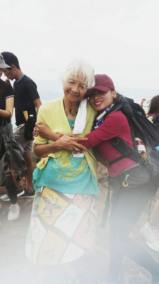
I saw a 6yr old boy with his father climbing and the bonus part is the 70yr old owner of the mountain visited the rockies while I was there so I was able to take a pic with her but I forgot to ask her name. But she's so cool. I suddenly missed my grandmom who passed away last year so I told her always take care. I even told her I love you lola (grandma in english) and she responded I love you too. I didn't feel tired that much because of the breathtaking view of taal and because of lola. <3
Congratulations, Your Post Has Been Added To The Steemit Worldmap!
Author link: http://steemitworldmap.com?author=yes103
Post link: http://steemitworldmap.com?post=a-hike-so-beautiful
Want to have your post on the map too?