Suez Canal
The Suez Canal connects the Mediterranean Sea with the Red Sea.The Suez Canal connects the Mediterranean Sea to the Red Sea, thereby significantly reducing the waterway from the Mediterranean to the Indian Ocean. Thus, the waterway from the Mediterranean to the waters of the Indian Ocean is significantly reduced. There is no need to go around Africa, which is a huge plus for maritime navigation. The channel is considered the geographical boundary between Asia and Africa.
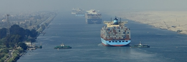
This most important sea route was put into operation on November 17, 1869.The canal was put into operation on November 17, 1869. It connected two seaports - Port Said in the Mediterranean Sea and the port of Suez - the north of the Gulf of Suez Red Sea.It connected two seaports, Port Said in the Mediterranean Sea and the port of Suez, in the north of the Gulf of Suez in the Red Sea. To the east of the canal stretches the lands of the Sinai Peninsula, and the west coast belongs to Africa.To the east of the canal stretch the lands of the Sinai Peninsula, and the west coast belongs to Africa. This waterway is considered the property of Egypt and brings to the state treasury annually not less than 5 billion dollars, passing through itself about 18 thousand vessels.This waterway is considered the property of Egypt and brings the state treasury no less than 5 billion dollars annually, with around 18,000 vessels passing through.
At the beginning of its operation, the length of the waterway was 164 km with a depth of 12 meters. Nowadays, after several extensions, the length has increased to 193 km with a depth of 24 meters. The length of the northern access is 22 km, the canal itself has an extent of 163 km and the length of the southern access is 9 km.The length of the northern access is 22 km, the canal itself has an extent of 163 km, and the length of the southern access is 9 km. The width of the water mirror varies from 120 to 150 meters. To the bottom the width narrows and reaches 45-60 meters.
The waterway connecting the Red and Mediterranean seas has no locks. This is very convenient, since vessels without any obstacles can get from one salt water body to another.This is very convenient, since vessels can get from one salt water body to another without any obstacles.
There are lakes on the canal. This is the Big Bitter Lake and the Little Bitter Lake.There are the Big Bitter Lake and the Little Bitter Lake. The big one is located to the north, and its area of the water mirror is 250 sq.The big one is located to the north, and its area of the water mirror is 250 square kilometers. M. km.The area of the small lake is 30 square kilometers. The area of the Small Gorky Lake is 30 square kilometers. km. As for the currents, in the winter months, water from bitter lakes flows to the north, and in winter it receives water from the Mediterranean Sea. To the south of the lakes the current varies depending on the tides.
History of the Suez Canal
The ancient Egyptians set themselves the task of connecting the Nile River with the Gulf of Suez. They needed it in order to establish a trade route with Punta, an ancient state located on the peninsula of the African Horn. The goods were very valuable - black wood, various paints, ivory, gold, animal skins, myrrh (gum).
It is assumed that in the XIX century BC. e. such a channel was laid, and Neil connected with the Red Sea. This waterway was tirelessly maintained by the pharaohs in working order. But centuries passed, people and states changed. Water jumper gradually lost its relevance and fell into decay, and then again there was a need for its restoration.
The ancient Greek historian Herodotus reports that in the 7th century BC. e. The Egyptians again started digging the canal, but did not finish it. Only in 100 years the Persian king Darius I completed this waterway. In the III century BC. e. he moved into the domain of Ptolemy Philadelph, who became the king of ancient Egypt after the death of Alexander of Macedon. Judging by the mention of ancient historians, the water flow was so wide that 2 ships sailed freely on it. In the 2nd century AD, the Roman emperor Troyan deepened the canal and expanded it. But then another era came, and the waterway from Africa to the Red Sea was abandoned.
Location
Centuries passed, and at the head of France stood Napoleon Bonaparte. In 1798, he ordered to carefully study the construction of the Suez Canal, which could connect the Mediterranean Sea with the Red Sea. A commission was organized, but its conclusion disappointed the emperor. Specialists came to the conclusion that the water level of the Red Sea is 9 meters higher than the similar level of the Mediterranean Sea. That is, it was necessary to erect a whole cascade of locks. The emperor was also named the sum of all the works - 45 million francs.
But it was not a financial issue that prevented Napoleon from building. The circumstances interfered. The Emperor was overthrown and sent into exile to St. Helena, and the talk about the grandiose project itself died out.
40 years have passed and already other experts have proved that the French commission was mistaken. There is no water difference. After that, the idea was born to build a canal. It was actively promoted by Ferdinand de Lesseps - a French diplomat with extensive ties and a great reputation. His idea of interest to the ruler of Egypt, Mohammed Said-pasha. This man once studied in Paris and received an excellent education.
Said Pasha gave Lesseps a concession for construction work, which began in 1859. The cost of the works was estimated at 200 million francs. This amount was issued and sold shares in the future dividends. Guarantors were the governments of Egypt and France, so this financial project was considered quite reliable.
The construction work was extremely difficult. People worked in the desert under the withering rays of the sun. The main problem was the supply of workers with construction materials and water. Fortunately, the channel of the old canal, which was used in antiquity, was discovered. It is for this reason that fresh water from the Nile was released.
However, the technical and household issues that were not initially considered quickly "ate" the sum originally set in the estimate. I had to issue additional shares. In total, the cost of all costs was almost 580 million francs. Lesseps promised to build a waterway for 6 years, but the work was stretched for almost 11 years.
At first they made the northern part of the water area and went out to the long, dried up bitter lakes. They represented the basins with a depth of 8-10 meters below sea level. Then came the turn of the southern part, which was connected with the Gulf of Suez.
The grand opening of a new waterway that cut the way from the Mediterranean Sea to the Indian Ocean for 8 thousand km took place on November 17, 1869. Representatives from almost all European countries attended the event. Celebrations lasted for a week, and their cost was 30 million francs.
In 1888, the maritime powers signed the International Convention. It guaranteed free passage through the channel to the courts of all states. However, during the World Wars, the UK and its allies controlled this strategically important sector. In 1956, President Nasser of Egypt announced the nationalization of the channel.
This caused a big stir in the world, as through the Suez Canal, 20% of all world shipments and 80% of US oil transportation were carried out. Economic interests gave birth to a war in which Egypt was defeated, and a strategically important waterway fell under the jurisdiction of the United Nations.
The next conflict arose in 1973, when the Arab-Israeli war began. In the canal area there were active military operations, and his work was paralyzed. Earned the waterway only in June 1975. Currently, it is under the jurisdiction of Egypt and brings good money to the state treasury.
Channel Exploitation
The capacity of the waterway is 76 vessels per day. Movement one-sided. On one ship is taken from 12 to 16 hours. First come the ships from Suez, then the ships from Port Said. Disperse counter ships in the Bolshoy Gorky Lake. The movement is organized strictly on schedule.
Huge loaded tankers can not cross a shallow waterway because of their deep draft. Therefore, they are unloaded, the channel is bypassed and again loaded at the other end. This creates certain inconveniences. Transportation of such goods is carried out by vessels belonging to Egypt.
In 1981, an underwater automobile tunnel was commissioned near Suez. It passes right under the bottom of the Suez Canal and connects the Sinai Peninsula with Africa. This architectural creation is considered one of the sights of Egypt. In 2001, railway and road bridges were opened in the northern part of the waterway. The highway bridge is 70 meters high. The railway bridge is a drawbridge. Thus, these facilities do not interfere with the passage of vessels with any dimensions.
For the world economy, this man-made creation is of great importance. It saves a lot of time, and, therefore, reduces the cost of transportation. The benefit is obvious, it remains only to rely on a stable political situation in this troubled region.
Reference
http://www.factruz.ru/world_ocean_2/suez-canal.htmhttp://www.factruz.ru/world_ocean_2/suez-canal.htm [Article is plagiarized from this source via machine translation]