Oroville Dam: DWR ups flows over the main spillway to 13,000 CFS...Water levels finally dropping.
But...they are also still posting lies and nonsense too. More on that in a second.
The Oroville Dam main spillway was just completed a couple months ago, and I don't know how well the concrete had even cured, but to be fair, from all accounts (and from youtube) it operated well during the first couple days that it was forced into service at about 8000 cubic feet per second (CFS.) Now, the flow has been upped to 13,000 CFS (more than the discharge of Maine's mighty Androscoggin River at Auburn) because the water levels were still rising.
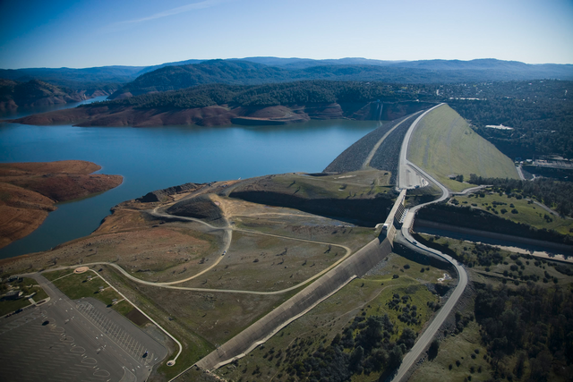
(The Oroville Dam, during more predictable times. Courtesy of megaconstrucciones.net.)
Now, thankfully (and possibly somewhat mysteriously-- depending on your view of the extent of the weather manipulation technology of the elites) the atmospheric river that was supposed to dump four inches over the catchment area of the dam by tomorrow, will probably now only produce half that amount. The water levels ARE finally dropping too. THAT'S GOOD!
But, take a look at the gobbledygook DWR published yesterday:

Obviously, the water levels and storage totals DID NOT remain exactly static all day yesterday.
Now, they are probably fudging figures, but hopefully, the dam is not still rising now as they claim the opposite today:
https://cdec.water.ca.gov/dynamicapp/QueryF?s=oro
But...of course, we HAVE TO BELIEVE THEIR FIGURES BECAUSE THAT'S ALL WE'VE GOT, as we have no live webcam at the Visitor Center to visually confirm things as we did during the crisis of 2017 (or at least during most of it...though they did take it down during the worst of that too. ) Of course, they promised to repair it by THIS PAST FEBRUARY...more proof of DWR duplicity.
I have no reason to doubt the water levels are dropping today, but I would much rather VERIFY than TRUST, given DWR's reputation.
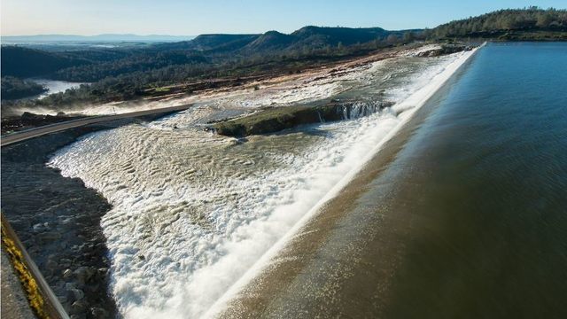
(Water rushes over the cheaply-built emergency spillway in 2017, forcing mass evacuations. Image courtesy of npr.org.)
The catchment area has rain right now, and is now predicted to get just .4" more by tomorrow morning, thankfully, making DWR look like they are geniuses or like they have a crystal ball. BUT...if the temps spike suddenly, and we get massive influxes of melted snow, this story could still get dicey, especially as an additional 1.25 inches of rain is supposedly on tap for Monday and Tuesday.
Let's just hope it is that easy for DWR to call the right people and get the rain diverted, because if not... we have to rely on their intelligence and honesty. (Yikes.)
Hi @mepatriot
As a follower of @haccolong this post has been randomly selected and upvoted by @hoaithu's Curation Trail with 20upvotes
This is random free upvote daily when you follow @haccolong
To get 3000points and receive additional rewards from your activities on Steemit, you can use Partiko app for your phone.
Nice! Thanks.
Howdy sir mepatriot! where is this big thing at, in Maine? Are you guys close to it? hopefully not down river from it.
Oh no...Auburn is on the Androscoggin (Maine's 3rd biggest river) 200 miles away and downstream from us (so to speak.) Nice set of falls there...
oh ok. I realize that I know nothing about Maine's geography. maybe if you guys would do something to make it into the news more often I would. lol.
LOL...