Elon musk y el cohete Argentino-Elon musk and the Argentine rocket- Elon Musk und die argentinische Rakete
Elon musk y el cohete Argentino
Con un cohete de Elon Musk, lanzan un satélite argentino que anticipará desastres naturales
Saocom podrá detectar inundaciones o incendios y crear mapas de glaciares. Cómo opera.
El satélite argentino Saocom será lanzado el sábado 6. Permitirá anticipar desastres
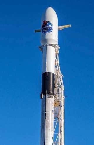
La base espacial Vandenberg es una instalación militar estadounidense, ubicada en el condado de Santa Bárbara, California. Desde una de sus plataformas de lanzamiento partirá este sábado 6, antes de la medianoche, el Satélite Argentino de Observación Con Microondas (Saocom) a bordo de un cohete Falcon 9 de la compañía SpaceX, la empresa del excéntrico millonario Elon Musk.
La particularidad de este cuerpo de paneles y antenas que ronda las 3 toneladas y mide 4,7 metros de alto, es que a través de un radar que emite un pulso de microonda, permitirá anticipar inundaciones, desastres naturales y crear mapas de desplazamiento de glaciares.
La construcción del Saocom 1A -tendrá un hermano mellizo en órbita para 2019- demandó casi 11 años para su desarrollado y fabricado, a cargo de la Comisión Nacional de Actividades Espaciales (CONAE) junto con organismos y empresas como la Comisión Nacional de Energía Atómica (CNEA), VENG, INVAP, contratista principal del proyecto. Es el primer lanzamiento que concretaría la CONAE en la gestión del actual gobierno.
Se trata de un satélite para observación, pero a diferencia de los ópticos o los térmicos, que toman fotografías o miden temperatura, su Radar de Apertura Sintética (SAR) opera en la porción de las microondas del espectro electromagnético. ¿Qué significa esto? Que se ve favorecida la observación nocturna ya que no depende de la luz solar y tampoco interfieren las condiciones de la atmósfera, como nubes o tormenta.
“El elemento central es una antena que emite pulsos de microondas que viajan a la velocidad de la luz e interactúan con la superficie terrestre. Una parte de dicha energía rebota en el suelo y retorna a la antena con información del suelo. El satélite la empaqueta y la remite al Centro de Control de la Misión, en la provincia de Córdoba, para que su procesamiento. Hay otras estaciones con las que tenemos convenio como la base Tolhuin en Tierra del Fuego, Svalbard en Noruega y en Matera, Italia”, detalla la doctora Laura Frulla, investigadora principal de la Misión SAOCOM, de la CONAE.
En cuanto a sus prestaciones, hay una larga nómina que incluye usos en agricultura, hidrología y prevención de desastres naturales. Brindará a los organismos públicos información de incendios, erupciones, terremotos, avalanchas y derrumbes. Además, ofrecerá servicios al agro para el monitoreo de crecimiento de cultivos y para analizar si es necesario fertilizar o no.
“En la lista figuran desde pronóstico de inundaciones, panorama de rutas colapsadas, monitoreo de delta, detección de petróleo en tierra o agua, identificar zonas en riesgo de inundación y dar alertas tempranas, detectar suelos muy secos con riesgo de incendios, hasta producir mapas de riesgo de enfermedades de cultivos. También se puede realizar seguimiento de buques, como el rompehielos ARA Almirante Irízar y detectar el camino con menos formación de hielo”, explica Frulla.
Una vez que alcance su órbita, obtendrá energía mediante sus paneles solares de 13 m2 y desplegará una antena radar de 35 m2 compuesta por siete paneles, formados cada uno por un conjunto de 20 antenas en miniatura.
El mismo desplegará una órbita polar de baja altitud, que se utiliza para supervisar la Tierra y cubrir su superficie por completo. El satélite se mueve casi en círculo y completa cada órbita en unos 90 minutos. Se ubicará en una órbita polar Sol-sincrónica a una altura de 619,6 km sobre la superficie de la Tierra. Esta órbita permite cartografiar globalmente la Tierra en gajos avanzando sobre las latitudes.
Una de las marcas que convierten al Saocom en un objeto diferente es el radar que opera en la banda L. Las bandas son intervalos de frecuencias del espectro electromagnético asignados a diferentes usos dentro de las radiocomunicaciones.
“Las antenas que operan en esta frecuencia son contadas con los dedos. La otra agencia que trabaja en banda L es la Agencia Japonesa de Exploración Aeroespacial (JAXA). Aunque Saocom es mucho más sensible, ya que es capaz de medir la humedad del suelo con una tasa de error del 10% y con un desplazamiento vertical-horizontal en el orden de los milímetros”, precisa Frulla.
Los satélites gemelos SAOCOM no estarán solos, ya que se integrarán con cuatro satélites desarrollados por la Agencia Espacial Italiana (AEI), llamados COSMO-SkyMed que en su conjunto formarán la constelación Sistema de Satélites para Gestión de Emergencias (SIASGE). Esta red integrada por 6 satélites operará en forma complementaria.
“Mientras que los radares de Saocom se mueven en banda L, una longitud de onda con menor resolución, pero de mayor profundidad; los italianos funcionan en banda X, que logra una mayor nitidez pero menor penetración. Es decir, mientras que con la L se puede analizar la base de los troncos y en un suelo desnudo penetrar hasta la raíz; los X se quedan en la copa de los árboles y no logran superar la rugosidad del terreno. Además, entre los Saocom y los COSMO-SkyMed habrá 10 minutos de diferencia, para obtener distintas observaciones de una misma superficie”, repasa Frulla.
Elon musk and the Argentine rocket

With an Elon Musk rocket, they launch an Argentine satellite that will anticipate natural disasters
Saocom will be able to detect floods or fires and create maps of glaciers. How it operates
The Argentine satellite Saocom will be launched on Saturday 6. It will allow to anticipate disasters
The Vandenberg Space Base is a US military installation, located in Santa Barbara County, California. From one of its launching platforms will start on Saturday 6, before midnight, the Argentine Satellite of Observation with Microwaves (Saocom) aboard a Falcon 9 rocket from the company SpaceX, the company of the eccentric millionaire Elon Musk.
The particularity of this body of panels and antennas that is around 3 tons and measures 4.7 meters high, is that through a radar that emits a pulse of microwave, will allow anticipate floods, natural disasters and create maps of displacement of glaciers .
The construction of the Saocom 1A - it will have a twin brother in orbit by 2019 - took almost 11 years to develop and manufacture, in charge of the National Commission for Space Activities (CONAE) together with organizations and companies such as the National Atomic Energy Commission ( CNEA), VENG, INVAP, main contractor of the project. It is the first launch that CONAE would specify in the management of the current government.
It is a satellite for observation, but unlike optics or thermals, which take photographs or measure temperature, its Synthetic Aperture Radar (SAR) operates in the microwave portion of the electromagnetic spectrum. What does this mean? That nocturnal observation is favored since it does not depend on sunlight and neither do the atmospheric conditions interfere, like clouds or storm.
"The central element is an antenna that emits microwave pulses that travel at the speed of light and interact with the Earth's surface. A part of that energy bounces off the ground and returns to the antenna with information from the ground. The satellite packages it and sends it to the Mission Control Center, in the province of Córdoba, for processing. There are other stations with which we have agreements such as the Tolhuin base in Tierra del Fuego, Svalbard in Norway and in Matera, Italy, "explains Dr. Laura Frulla, principal investigator of the SAOCOM Mission of CONAE.
In terms of benefits, there is a long list that includes uses in agriculture, hydrology and prevention of natural disasters. It will provide public agencies with information on fires, eruptions, earthquakes, avalanches and landslides. In addition, it will offer services to the agriculture for the monitoring of crop growth and to analyze if it is necessary to fertilize or not.
"The list includes flood forecast, panorama of collapsed routes, delta monitoring, detection of oil on land or water, identify areas at risk of flooding and give early warnings, detect very dry soils with fire risk, to produce maps of risk of crop diseases. You can also track ships, such as the ARA Almirante Irízar icebreaker and detect the path with less ice formation, "explains Frulla.
Once it reaches its orbit, it will obtain energy through its 13 m2 solar panels and deploy a 35 m2 radar antenna composed of seven panels, each formed by a set of 20 miniature antennas.
It will deploy a low altitude polar orbit, which is used to monitor the Earth and cover its surface completely. The satellite moves almost in a circle and completes each orbit in about 90 minutes. It will be located in a Sun-synchronous polar orbit at a height of 619.6 km above the surface of the Earth. This orbit allows global mapping of the Earth in segments advancing over latitudes.
One of the marks that make the Saocom a different object is the radar that operates in the L band. The bands are frequency ranges of the electromagnetic spectrum assigned to different uses within radio communications.
"The antennas that operate on this frequency are counted with the fingers. The other agency that works in band L is the Japanese Agency of Aerospace Exploration (JAXA). Although Saocom is much more sensitive, since it is capable of measuring soil moisture with an error rate of 10% and with a vertical-horizontal displacement in the order of millimeters, "says Frulla.
The SAOCOM twin satellites will not be alone, since they will be integrated with four satellites developed by the Italian Space Agency (AEI), called COSMO-SkyMed that together will form the constellation Satellite System for Emergency Management (SIASGE). This network composed of 6 satellites will operate in a complementary manner.
"While Saocom radars move in L-band, a wavelength with lower resolution, but of greater depth; Italians work in X band, which achieves greater clarity but less penetration. That is, while with the L you can analyze the base of the trunks and in a bare soil penetrate to the root; the X remain in the treetops and can not overcome the rugosity of the terrain. In addition, between the Saocom and the COSMO-SkyMed there will be 10 minutes of difference, to obtain different observations of the same surface, "says Frulla.
Elon Musk und die argentinische Rakete

Mit einer Elon Musk Rakete starten sie einen argentinischen Satelliten, der Naturkatastrophen vorwegnimmt
Saocom wird in der Lage sein, Überschwemmungen oder Brände zu erkennen und Karten von Gletschern zu erstellen. Wie es funktioniert
Der argentinische Satellit Saocom wird am Samstag, den 6. Januar gestartet. Er wird es ermöglichen, Katastrophen vorherzusehen
Die Vandenberg Space Base ist eine US-Militäranlage in Santa Barbara County, Kalifornien. Von einer seiner Startplattformen startet am Samstag, den 6., vor Mitternacht, der argentinische Beobachtungssatellit mit Mikrowellen (Saocom) an Bord einer Falcon 9-Rakete der Firma SpaceX, der Kompanie des exzentrischen Millionärs Elon Musk.
Die Besonderheit dieses Gremiums aus Antennen und Panelen, das etwa 3 Tonnen misst und 4,7 Meter hoch ist, ist, dass es durch ein Radar, das einen Mikrowellenpuls aussendet, Überschwemmungen, Naturkatastrophen und Karten von Gletschern ermöglichen wird.
Der Bau der Saocom 1A - es wird bis 2019 einen Zwillingsbruder im Orbit haben - dauerte fast 11 Jahre, um die Nationale Kommission für Weltraumaktivitäten (CONAE) gemeinsam mit Organisationen und Unternehmen wie der Nationalen Atomenergie zu entwickeln und herzustellen Kommission (CNEA), VENG, INVAP, Hauptauftragnehmer des Projekts. Es ist der erste Start, den CONAE im Management der aktuellen Regierung spezifizieren würde.
Es ist ein Satellit für die Beobachtung, aber im Gegensatz zu Optiken oder Thermiken, die Fotos aufnehmen oder Temperatur messen, arbeitet sein Radar mit synthetischer Apertur (SAR) im Mikrowellenbereich des elektromagnetischen Spektrums. Was bedeutet das? Diese nächtliche Beobachtung wird bevorzugt, da sie nicht vom Sonnenlicht abhängt und auch nicht die atmosphärischen Bedingungen stören, wie Wolken oder Sturm.
"Das zentrale Element ist eine Antenne, die Mikrowellenimpulse aussendet, die sich mit Lichtgeschwindigkeit bewegen und mit der Erdoberfläche interagieren. Ein Teil dieser Energie prallt vom Boden ab und kehrt mit Informationen aus dem Boden zur Antenne zurück. Der Satellit verpackt sie und Sie sendet sie an das Missionskontrollzentrum in der Provinz Córdoba zur Verarbeitung. Es gibt weitere Stationen, mit denen wir Vereinbarungen haben, wie die Tolhuin-Basis in Feuerland, Svalbard in Norwegen und Matera in Italien ", erklärt Dr. Laura Frulla, Principal Investigator der SAOCOM Mission von CONAE.
In Bezug auf die Vorteile gibt es eine lange Liste, die Anwendungen in der Landwirtschaft, Hydrologie und Prävention von Naturkatastrophen umfasst. Es informiert die Behörden über Brände, Eruptionen, Erdbeben, Lawinen und Erdrutsche. Darüber hinaus bietet es der Landwirtschaft Dienstleistungen zur Überwachung des Pflanzenwachstums und zur Analyse, ob eine Düngung erforderlich ist oder nicht.
"Die Liste umfasst Hochwasservorhersage, Panorama kollabierter Routen, Deltamonitoring, Erkennung von Öl an Land oder Wasser, Hochwassergefährdung und Frühwarnung, Erkennung sehr trockener Böden mit Brandrisiko, Erstellung von Karten zum Risiko von Pflanzenkrankheiten Sie können auch Schiffe wie den Eisbrecher ARA Almirante Irízar verfolgen und den Weg mit weniger Eisbildung erkennen ", erklärt Frulla.
Sobald es seine Umlaufbahn erreicht, wird es Energie durch seine 13 m2 Sonnenkollektoren erhalten und eine 35 m2 Radarantenne einsetzen, die aus sieben Paneelen besteht, die jeweils aus einem Satz von 20 Miniaturantennen bestehen.
Es wird eine polare Umlaufbahn in geringer Höhe bereitstellen, mit der die Erde überwacht und ihre Oberfläche vollständig bedeckt wird. Der Satellit bewegt sich fast in einem Kreis und beendet jede Umlaufbahn in etwa 90 Minuten. Es wird in einer sonnensynchronen polaren Umlaufbahn in einer Höhe von 619,6 km über der Erdoberfläche liegen. Diese Umlaufbahn ermöglicht eine globale Kartierung der Erde in Segmenten, die sich über die Breitengrade erstrecken.
Eine der Markierungen, die den Saocom zu einem anderen Objekt machen, ist das Radar, das im L-Band arbeitet. Die Bänder sind Frequenzbereiche des elektromagnetischen Spektrums, die verschiedenen Nutzungen innerhalb der
Funkkommunikation zugeordnet sind.
"Die Antennen, die auf dieser Frequenz arbeiten, werden mit den Fingern gezählt. Die andere Agentur, die in Band L arbeitet, ist die Japanische Agentur für Aerospace Exploration (JAXA). Obwohl Saocom viel empfindlicher ist, da es in der Lage ist, Bodenfeuchtigkeit zu messen Fehlerquote von 10% und mit einer vertikal-horizontalen Verschiebung in der Größenordnung von Millimetern ", sagt Frulla.
Die SAOCOM Zwillingssatelliten werden nicht allein sein, da sie mit vier von der italienischen Raumfahrtbehörde (AEI) entwickelten Satelliten COSMO-SkyMed integriert werden, die zusammen die Satellitenkonstellation für Notfallmanagement (SIASGE) bilden. Dieses aus 6 Satelliten bestehende Netzwerk wird komplementär arbeiten.
"Während sich die Saocom-Radargeräte im L-Band bewegen, einer Wellenlänge mit geringerer Auflösung, aber von größerer Tiefe, arbeiten die Italiener im X-Band, was zu mehr Klarheit, aber weniger Durchdringung führt. Das heißt, mit dem L können Sie die Basis der Stämme analysieren und in einem nackten Boden bis zur Wurzel eindringen, die X bleiben in den Baumwipfeln und können die Rauheit des Geländes nicht überwinden.Außerdem werden zwischen dem Saocom und dem COSMO-SkyMed 10 Minuten Unterschied sein, um verschiedene Beobachtungen zu erhalten die gleiche Oberfläche ", sagt Frulla