Fossil Rivers - The Dance of the Mississippi (and other rivers)
All imagery and excerpts used is in this article are courtesy of the US Army Corps of Engineers and from from the source: Fossil Rivers
Rivers are living, flowing streams of energy
River are wonderful, diverse and ever changing. The flow with life. Since the dawn of human existence rivers have been a great draw, for water, agriculture and transport. During this time man has lived by them but also tried to tame them, straightening them, building large embankments such as those along the Mississippi in North America. The problem is you can only really tame a river for so long, eventually a great, incomprehensible volume will fall in the watershed and come powering down from source to sea. Nothing can stop water. What I like about this article I found is that there is such a thing as 'fossil rivers', that is the mapping old river beds from looking for the alluvium deposits that rivers laid down during their evolution. The geological history of rivers!
This beautifully written article, Fossil Rivers, shows a number of striking visual geological representations across the course of the Mississppi River, crafted by that branch of the US Military - the US Army Corps of Engineers. How colorful and wonderful they are!
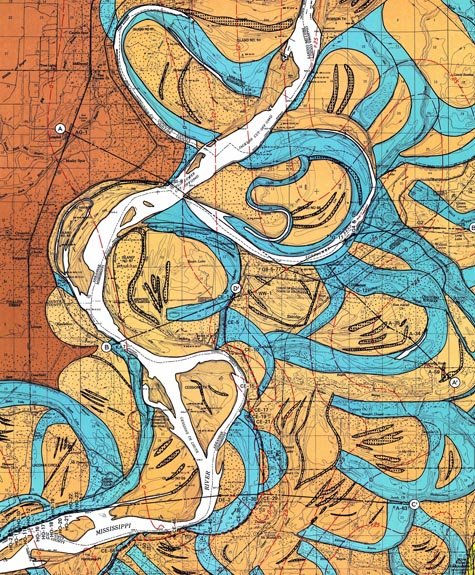
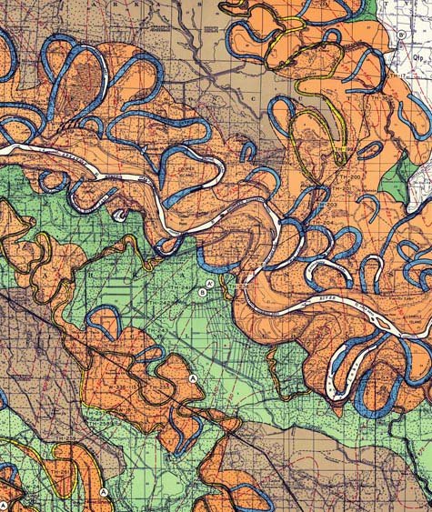
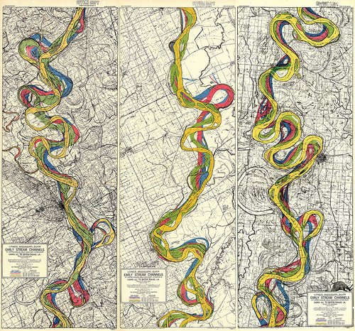
The geological history of the Mississippi River has been extensively documented by the U.S. Army Corps of Engineers for more than a century. The Corps has produced maps, charts, graphs, and illustrated reports. Taken together, these offer a snapshot of the Mississippi, from source to sea, including the river’s “subsurface conditions,” its ancient geological forms, and its present-day urban surroundings. We see the grids of existing cities – New Orleans, Baton Rouge, St. Louis – built upon the shores of the world’s fourth-largest river; and we see remnant landscapes of eroded bedrock from a time before humans ever set foot upon North America. This is the “ancestral” Mississippi, a lost waterscape of “meander belts” and “alluvial aprons,” now visible only to the eyes of trained geologists.
Rivers scour bends in the landscape, known as meanders that, viewed from above, are great to observe and to study by geographers. Isn't everyone's favourite geographical feature the 'Oxbow lake'?
These maps document time, in other words, as much as they document geography.
The way that rivers evolve begs the question as to why so many of the worlds cities and population centers live by them? We are literally living on flood plains that should be washed away. If they change so rapidly, why do we do so? Well they have huge financial benefits. Flood plains (and greater plains that flood in bigger events, like a 1 in 1000 year event) are fertile, they provide a means of transport and trade, they are defensive features. But now, its because we have become so good at engineering them. Stop them from flooding, re route them, tame them. My favourite example of incredible minds coming together to engineer a river is the Thames Barrier of London - the problem is that its worked well for the last 30 or so years, but will climate change its going to need updating, or London may see new catastrophic flooding, which itself will have huge financial impacts.
The sheer fact that cities have been built in the midst of this mobile terrain is either horrifying or vaguely hilarious. The “land” all these cities are constructed on is actually hundreds of thousands of acres of displaced mud, thick sheets of soil washed down from the north and compacted over time into something approximating solid ground.
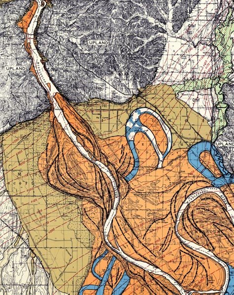
Indeed, what the Army Corps of Engineers discovered while producing these maps is that the Mississippi River has changed channel completely – and it has done this hundreds, even thousands, of times.
Take a pit of sand, pour some water on it and it creates a mini river. Do this everyday and the the river will likely change direction, cutting new channels across the sand. Rivers do this in much the same way, but over a much larger time period.
If you are the Army Corps of Engineers, however – a branch of the U.S. military – then your mandate is to secure the nation’s waterways. The Mississippi’s relentless change in shape and direction is thus not a topic for poetry but a matter of national security. Through their infinite encyclopedia of the river – constantly updated, never complete – the Corps hopes to control these riverine transformations. Their goal is made almost comically obvious when you note that these maps are printed by the “War Department.”
This is a battle strategy: it is geomorphic warfare.
Geomorphic warfare! Declaring a war against the principles of evolving landscapes and geography - how very human to try to over ride these things! Man is amazing and can do wonderful things. Man has been living with nature and bending it to its needs, but ultimately nature has more power and these will always be observed in the end.
What is your local river, or does your country have a huge, powering force of nature similar to the Mississippi? They are the world over and are even observed on other worlds, such as Mars

T.S. Eliot (born in St. Louis) once wrote about the immense power of the Mississipii and this is a description that has forever been emblazened in my mind. He wrote The Strong Brown God.
I do not know much about gods; but I think that the river is a strong brown god - sullen, untamed and intractable,
Patient to some degree, at first recognized as a frontier,
Useful, untrustworthy, as a conveyor of commerce,
Then only a problem confronting the builder of bridges.
The problem once solved, the brown god is almost forgotten By the dwellers of cities - ever, however, implacable, Keeping his seasons and rages, destroyer, reminder Of what men choose to forget.
🌎🏠 Live RENT FREE / FREE HOLIDAYS by house-sitting 🌎🏠
⛏ Mine JSE Coin in your web browser & website ⛏
⛏ Mine Pi Coin on your smart phone (invite only code - cryptojones88) ⛏

Dronegraphica Website
Facebook
Instagram
All images are my own and If you like them please upvote, follow, comment, ask questions or get some discussion going, It’d be great to hear from you!

Congratulations @dronegraphica! You have completed the following achievement on the Steem blockchain and have been rewarded with new badge(s) :
You can view your badges on your Steem Board and compare to others on the Steem Ranking
If you no longer want to receive notifications, reply to this comment with the word
STOPBeautiful maps and great info! I live just an hours drive from the river and The Mississippi River Museum has so many interesting exhibits about the river.
Ah very cool! It's a mighty spectacle of nature :) beast when it bursts
Posted using Partiko Android
There are so many towns and cities built on the banks of that river. The lessons from history are constantly ignored.