R2R Travelogue 17: Lewiston, Idaho and the Famous Lewis & Clark Expedition
Day Twenty Three: Long a student of history, I think one of the remarkable chapters in the story of early America was the famous Lewis and Clark Expedition.
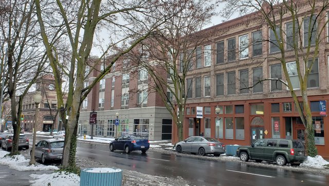
Since the expedition passed through the area, Lewiston, Idaho was named in honor of it and sits at the confluence of the Snake and Clearwater Rivers. Across the Snake River from Lewiston is Clarkston, Washington.
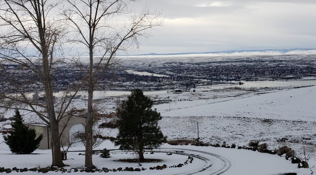
Photo: Confluence of the Clearwater (Left) and Snake (Top) Rivers
This can be seen in my photo above, where Lewiston, Idaho is to the left and Clarkston, Washington is across the Snake River to the right.
Spending a day in the area, I am pleased to bring it to life a bit for you.
Background - The Lewis and Clark Expedition of 1804 to 1806
To truly appreciate this area, it is very helpful to first have an idea of its history. It is closely linked to that of the famous Lewis and Clark Expedition. So ... What is that you may ask?
The third President of the United States, Thomas Jefferson, commissioned Meriwether Lewis to lead an American "Expedition to the Pacific." The objective was to find a route across uncharted parts of the West to the Pacific, after the Louisiana Purchase.
Source: Wikipedia - Map of Louisiana Purchase
The Louisiana Purchase was land purchased from Napoleon Bonaparte of France, who needed funding for his military campaigns in Europe, particularly against the British. In the original negotiations, the objective of America was simply to acquire New Orleans and have the resulting free access to the Gulf of Mexico down the vital inland waterways linked to the Mississippi River. It was critical to commerce in that early part of American history.
Instead, America ended up with the remarkable bargain of purchasing 828,000 sq. mi. (2,140,000 km2; 530,000,000 acres) of land for about $15 million USD (in 2017's depreciated USD about $600 billion). With the Louisiana Purchase completed on 10 March 1804, it formally removed all remaining obstacles to commencing the famous Lewis and Clark Expedition.

Source: National Park Service - Map of Lewis and Clark Expedition
Here is a very abbreviated timeline of what followed:
- 18 July 1803: William Clark accepts Lewis’ offer of a trip to the Pacific. (Note: Many other pre-expedition details are covered by the timeline link provided above)
- 21 May 1804: The entire "Corps of Discovery" (their official name for themselves ...) departs St. Charles, Missouri at 3:30 p.m.
- 2 November 1804: The Expedition determines the location of their winter camp, Fort Mandan (14 miles west of present-day Washburn, North Dakota)
- 4 November 1804: Frenchman Touissaint Charbonneau hired as an interpreter. One of his Shoshone wives, Sacagawea, will join the Expedition.
- 11 February 1805: A baby, Jean Baptiste, is born to Sacagawea and Touissaint Charbonneau.
- 7 April 1805: Expedition of thirty-one men (one a black slave), one woman, one baby and a dog starts up the Missouri River into uncharted territory.
- 13-16 June 1805: Lewis finds the Great Falls of the Missouri River. To his dismay, Lewis finds four additional falls. Lewis is charged by a grizzly bear and chased into the Missouri River. Lewis administers water to an ailing Sacagawea from the Sulphur Springs (near present-day Great Falls, Montana).
Note: In a visit to the Great Falls area in July 2018, I toured the Lewis and Clark Interpretive Center. Among the many things I learned in this very impressive place was that Sacagawea nearly died here. The curative powers of the sulfur water are what was credited for her miraculous recovery. She was a critical part of the Expedition's success. - 12 August 1805: Lewis and his party are the first American citizens to cross the Continental Divide at Lemhi Pass. His small party enters present-day Idaho.
- 10 October 1805: Expedition reaches the Snake River and camps near present-day Lewiston, Idaho. They cross into present-day Washington.
- 30 December 1805: Fort Clatsop (near present-day Astoria, Oregon) was completed on the evening of this day. This would be the Expedition’s home for the next 3 1/2 months. Most of time was spent hunting for “poor” elk, trading for roots and other food, and making clothing for their return trip home.
- 23 March 1806: The Expedition departs Fort Clatsop by canoe to begin its return journey.
- 5 May 1806: Expedition leaves Washington and crosses into present-day Idaho (near Lewiston).
- 7 July 1806: Lewis’ party crosses the Continental Divide at present-day Lewis and Clark Pass in Montana.
- 14 August 1806: Expedition reaches the Mandan Villages, where they had spent the winter in 1804.
- 23 September 1806: Corps of Discovery arrives in St. Louis about noon after two years, four months and 10 days. They are home.
- 28-30 December 1806: Lewis arrives in Washington D.C. President Jefferson receives Lewis and Sheheke, a chief of the Mandans.
- 5 August 1807: Final financial record of the Expedition, cost was $38,722.25. Note: Clearly money went much further in those days!
- 11 October 1809: At 3:00 a.m., Meriwether Lewis dies at Grinder’s Stand on the Natchez Trace (near present-day Hohenwald, Tennessee). He was 35 year old!
If you are a history enthusiast like me, you may want to follow the links provided above to learn more about this remarkable time in American history.
With this brief introduction to the Lewis and Clark Expedition, dear reader, we'll now move into the rest of this post. About the area around the confluence of the Snake and Clearwater Rivers and the cities of Lewiston, Idaho and Clarkston, Washington found there, as they are today.
We'll be coming back to this famous expedition later on in my "journey," when I leave this area and travel the Lochsa River Scenic Byway in Idaho & Montana, which was also a part of the Lewis and Clark Expedition (although far wiser than I, they didn't go through this rugged mountain country in "the dead of winter" ... 😉)
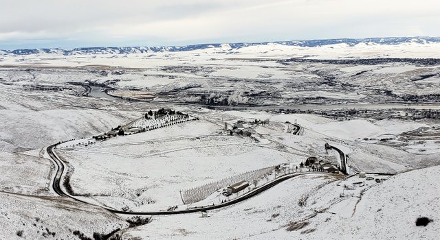
Confluence of the Snake and Clearwater Rivers
With its headwaters starting near Yellowstone National Park in Wyoming, the Snake River drains a vast area before dropping down through Hells Canyon - the deepest river-carved gorge in North America. Which is a short distance upstream from Lewiston, Idaho.
The Clearwater River drains a much smaller geographical area, but has nearly same volume of water, at the convergence of these two great rivers. This is due to the abundant rain and snow in the mountains of the central panhandle of the State of Idaho, through which it flows.
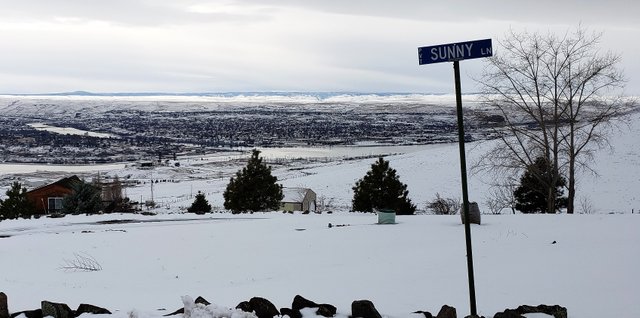
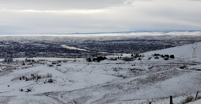
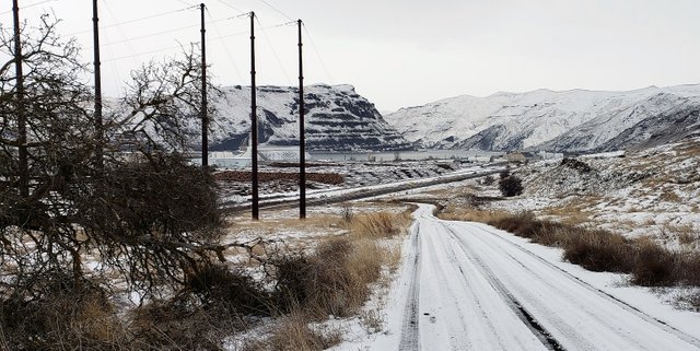
To get a better view of the confluence, I needed to gain some elevation. Climbing the nearby Lewiston Hill, on the old "Spiral Highway" was just the ticket.
How did this highway come to be? Glad you asked ... 😉
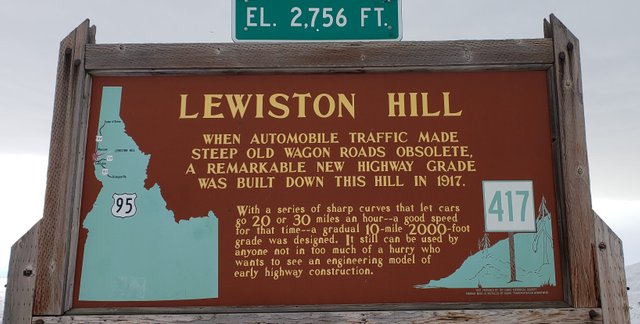
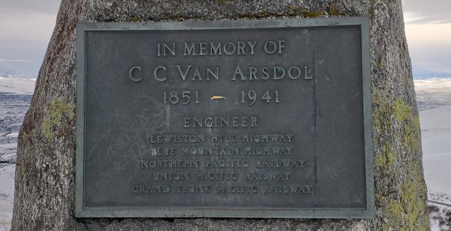
Photo: Memorial to the Designer of the "Spiral Highway" up Lewiston Hill
Starting up the highway, after turning off from U.S. Highway 12 outside of Lewiston, you know you are in for an adventure. It has slow, winding curves, so you definitely don't want to head up this road unless you have plenty of time to enjoy it. Safely ...
)
)
Photos: Driving Up the "Spiral Highway"
For many years, the trip up this steep incline was the primary route to places further north, like the nearby university towns of Pullman, Washington (Washington State University) and Moscow, Idaho (University of Idaho).
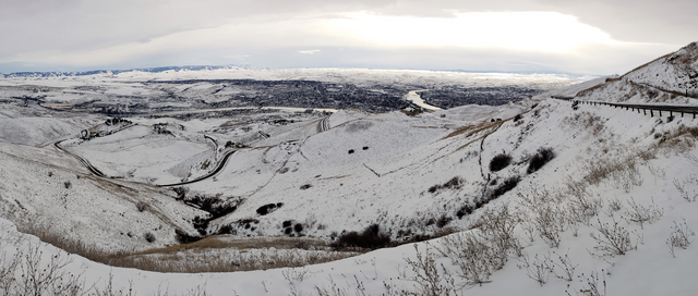
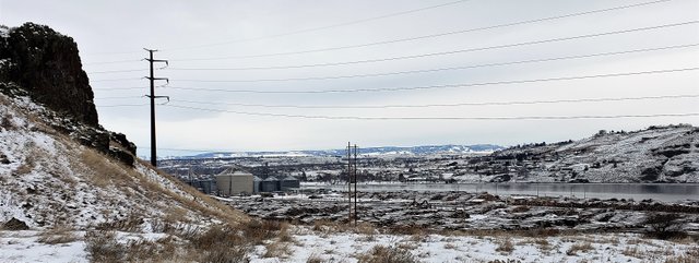
Photo: Panoramic View of the "Spiral Highway"
Today, the route of U.S. Highway 12 bypasses it.
Finally reaching the top, this is what you are rewarded with in having the best view of the whole countryside available.
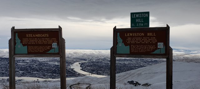
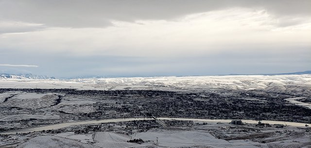
Photos: Confluence of the Snake and Clearwater Rivers from Top of Lewiston Hill
Atop this hill, we see we have gained an impressive 2,000 feet (610 m) in elevation. Very low for the part of the country in which I live, but ... "High" for around these parts! 😊
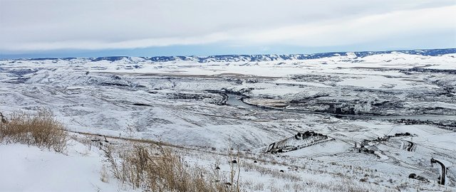
Photos: Up the Clearwater into Idaho. Up the Snake into Hells Canyon
Soon after leaving this area and heading up either river, you are soon in spectacular mountain country, in either direction. These are beautiful rivers and, if your time permits, you may want to further read about them, with the links provided to you here.
A very brief listing of some of the many attractions in the nearby area:
- Hells Canyon National Recreation Area - Many enjoy "power boating" up into this canyon, from the Lewiston / Clarkston area.
- Wallowa Lake and the Eagle Cap Wilderness - A spectacular part of the remote Wallowa Mountains of northeastern Oregon (Trivia Note: The setting for the #1 international, best-selling book, "The Shack").
- The famed "River of No Return" - the Salmon River and McCall, Idaho - A favorite vacation spot for family.
- Selway-Bitteroot Wilderness Wilderness - The thrid largest protected area in mainland U.S., some of the most spectacular mountain country in the western United States. The journal of the Lewis and Clark Expedition indicate they barely survived getting through this part of their journey.
- Dworshak Dam on the Clearwater River - With a height of 717 feet (219 m), Dworshak is the third tallest dam in the United States and the tallest straight-axis concrete dam in the Western Hemisphere. It supplies a great deal of hydroelectrically-generated energy for this region. Note: The kokanee fish there, a type of freshwater Salmon, are a family favorite!
The Port of Wilma and Lewiston, Idaho
The confluence of the Snake and Clearwater Rivers creates a major inland waterway, in this part of the western United States. The result is the inland-most port in this part of the country - 465 miles (748 km) from the Pacific Ocean. Elevation this far from the ocean? A mere 745 feet (227 m)!
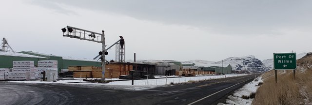
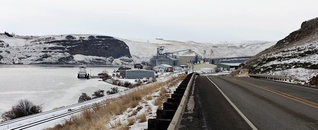
Photos: Port of Wilma, Upriver, Grain Silos, and Downriver
Given the proximity of the nearby Palouse Region and its vast wheat fields, one would expect the majority of this port's traffic to be agriculturally based. As we can see, that is clearly not all that passes through this port. There are thousands of logs stacked here from the nearby forests in the panhandle of Idaho!
Going back in time, the area in which we find Lewiston today has played an important role in the history of this part of the country.
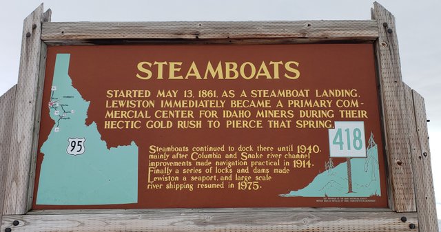
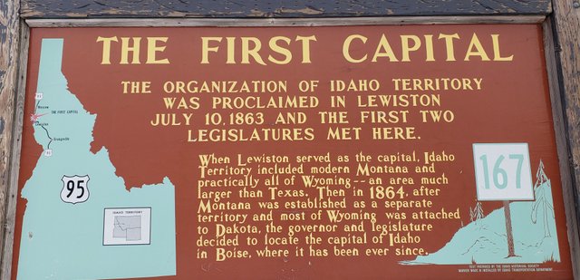
Photos: Early History of Lewiston
From the time the Lewis and Clark Expedition passed through here, we can see there has been quite a history in this location.
You'll note, dear reader, how mining played a role in the early history of this area. Reading about the settling of many places in the western United States, it is not uncommon that the first people into many regions were miners, seeking their fortunes.
Behind them came those who provided supplies and means for their survival. Like farmers ...
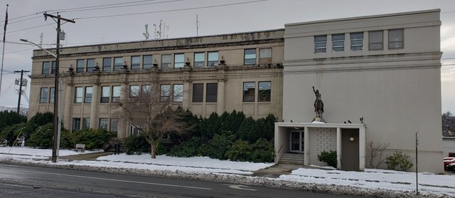
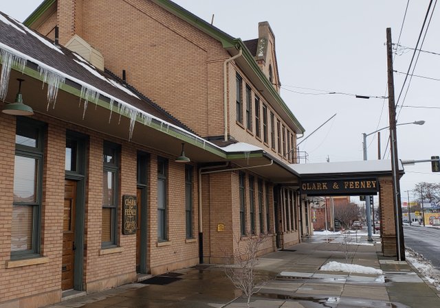
Photos: Nez Perce County Courthouse and Old Train Station in Lewiston
The Nez Perce are the native people of this part of the United States. There is quite a history associated with them and their famous leader, Chief Joseph. In their honor, this county in Idaho was named.
- History Note: The history of Chief Joseph's leadership of his people, in the face of the overwhelming numerical superiority of the American army, is extraordinary.
After a band of warriors under the leadership of another Nez Perce chief massacred some white settlers, he knew what was coming and led his people on a remarkable journey to try escaping into Canada ...
If you enjoy this type of history at all, I highly recommend you follow the link provided above and read the story.
Trains were a prominent part of early American history, but much less so today. The old train station now appears to be housing a law firm.
Looking at Lewiston today, there is a lot to like, if as I do, you enjoy small-town America.
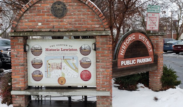
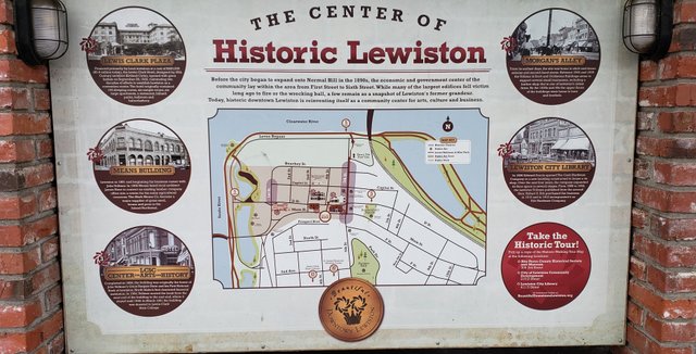
Photos: Historic Downtown Lewiston
A lot of work has gone into restoring a lot of the historic section of downtown Lewiston, near the confluence of the Snake and Clearwater Rivers.
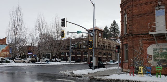
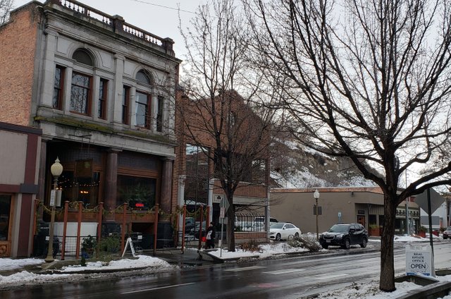
Photos: Downtown Lewiston
I really enjoyed walking around some of the downtown streets, which are only a few blocks from the confluence of the Snake and Clearwater Rivers. The local people have done an admirable job of rehabilitating many of this town's old buildings.
One of the fascinating aspects of the Steem blockchain, to me, is the opportunity to "see" other parts of the world through the eyes of our fellow Steemians. While quite time consuming, I enjoyed putting this post together for you, dear reader, about one of the better parts of the country, from my experience.
Postscript for Day Twenty Three
Traveling this region in the winter can be somewhat hazardous. Thankfully, as stated before, I am well prepared to deal with it.
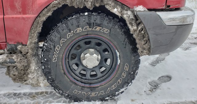
Photo: @roleerob's Truck Hard at Work
Thought you might enjoy seeing how my little truck is doing. Consider this a free plug for these excellent tires from Goodyear - recommended to me by a representative of a local dealer, Discount Tires. Unquestionably one of the best recommendations I have ever received.
Earlier on this trip, down in Tucson, Arizona, I stopped in to a local branch of this western tire store chain, to have the air pressure checked. The representative there said my tires were in "nearly new" condition and they have almost 30,000 miles on them! 👍
Glad to have had a break (at least somewhat ...) in the weather to have been able to capture these images. Today, as I am finishing the writing of this post, it is another dreary northwest winter day with more snow falling. In fact, we've had to cancel plans to visit a local historic mill, due to there already being over a foot of snow and it is still coming down ... 😧
Closing
Another fine day of "seeing" this part of our country in "@roleerob's excellent adventure!" Thanks for going along with me, dear reader. I hope you have enjoyed it. I’d love to hear any feedback you may be inspired to provide.
Until "next time," all the best to you for a better tomorrow, as we all work together to build our Steem Community! 👍 😊
Respectfully,
Steemian @roleerob
Posted using SteemPeak and “immutably enshrined in the blockchain” on Wednesday, 13 February 2019!
"R2R" Note: My "shorthand" way of referring to what I first wrote about in my Reflections: My "Road to Recovery" Trip post. "Road to Recovery" <=> "R2R" ... 😉
Image sources, unless otherwise noted: My trusty smartphone!

If you liked this post, you might enjoy others in my "Road to Recovery" Travelogue series:
- Travelogue, Day 1: Ribeye, Colorado
- Travelogue, Day 2: Navajo Nation and Canyon de Chelly - Awarded by c-cubed, c-squared, steemitworldmap, traveldigest, and trufflepig! 😊
- Travelogue, Day 3: Mogollon Rim, Copper Belt, and Sonora Desert - Awarded by trufflepig again!
- Travelogue, Day 4: Catalina State Park in Tuscon, Arizona - Awarded by c-squared, steemitworldmap, and traveldigest! 😊
- Travelogue, Day 5: Baboquivari, Sacred Peak in Arizona - Awarded by steemitworldmap and trufflepig! 😊
- Travelogue, Day 5: Organ Pipe National Monument in Arizona - Awarded by c-squared, steemitworldmap, traveldigest, and trufflepig! 😊
- Travelogue, Day 6: Reaching the Ocean - Awarded by travelfeed and trufflepig! 😊
- Travelogue, Day 7: Sabbath Rest and Morro Bay, California - Awarded by steemitworldmap, traveldigest, and trufflepig! 😊
- Travelogue, Day 8: Hearst Castle in San Simeon, California - Awarded by steemitworldmap and traveldigest! 😊
- Travelogue, Day 9: Monterey Peninsula of California - Awarded by steemitworldmap and travelfeed! 😊
- Travelogue, Day 10: Redwood Hill Farms and Sonoma County, California - Awarded by steemitworldmap and traveldigest! 😊
- Travelogue, Day 10: Sonoma Coast State Park of California - Awarded by steemitworldmap and traveldigest! 😊
- Travelogue, Day 11: Mendocino, California - Awarded by steemitworldmap and traveldigest! 😊
- Travelogue, Day 12: Redwood Forests of Northern California - Awarded by steemitworldmap, traveldigest, and trufflepig! 😊
- Travelogue, Day 13: Crater Lake National Park in Oregon in Winter ... - Awarded by steemitworldmap, traveldigest, and trufflepig! 😊
- Travelogue, Day 13: Rogue River Gorge in Oregon - Awarded by steemitworldmap and traveldigest! 😊
- Travelogue, Day 20: Oregon Scenic Byway to Pendleton - Awarded by c-cubed, c-squared, and trufflepig! 😊
- Travelogue, Day 21: The Blue Mountains and the Palouse - Awarded by c-squared! 😊
This post was shared in the Curation Collective Discord community for curators, and upvoted and resteemed by the @c-squared community account after manual review.
@c-squared runs a community witness. Please consider using one of your witness votes on us here
Hiya, @itchyfeetdonica here. I just curated your post to our daily Travel Digest #434 and upvoted it through @steemitworldmap. If you enjoy what we do, consider supporting us by:
Vote for the Daily Traveldigest
Follow our curation trail
Delegate Steempower
The more support we get, the more we can give back! :)
Thank you @steemitworldmap / @itchyfeetdonica for the Honorable Mention. The encouragement and support is always much appreciated! 😊
I am so surprised that a new movie hasn’t been made about this amazing journey and its impact to the country. I can also relate to all of us here as pioneers are also seeking for better opportunities for the collective and not the individual which is inspirational!
Posted using Partiko iOS
Agreed @newageinv ...
... as I would definitely watch it. The lives of these people have always been fascinating to me, as a testament to what people are capable of, if they are resolute and courageous.
Today, we have so little idea (at least I don't think so ...) of "what it takes," but I would imagine, if our lives were literally "on the line," we would find out quickly!
Howdy sir roleerob! what another great addition to the trip posts and travelogue! So many interesting places and facts that presented here, it would take me days to put together one like this!
I really love the small towns of America and all the old style buildlings like the court houses!
Another great post sir, well done!
Thanks for the words of encouragement @janton ...
... it definitely takes me a lot of time. But ... It pays well! I think I am making about ohhh ... I dunno ... Maybe $0.10 an hour ... 😉
hahaha! howdy sir roleerob! Are we totally insane to be spending so much time here? As great as it is and as brilliant as so many people are who are trying to tie it into real world applications and uses I still don't know if it's a total crap shoot or not!
Well @janton ...
... I'm okay, but I have wondered about you from time to time ... Hahaha! 😉
Seriously, I obviously don't know the future. I try to "console myself" with writing being "therapeutic" or something like that ... 😊 And let the future take care of itself.
I do still believe in the long-term potential or I would have stopped ...
Well sir, it makes me feel better to have reasonable, intelligent, analytical people out there who still believes in it!
This is a very cool historical article. Thanks for your great photos and all of this amazing information. So, the Government of the US made an excellent deal with that land! Such a bargain, wow!!! Napoleon was not that smart after all, was he?
Those icicles on the roof of the houses look extremely dangerous... 😮
It's always interesting @trincowski ...
... to look "in the rearview mirror" of life and wonder why people do what they do.
The challenge is looking "out the windshield" of life, see clearly what's coming, and respond appropriately.
Presumably, Napoleon knew he faced a very real and much more immediate challenge in overcoming his adversaries in Europe. The potential of what "might be" in America was way off in the future.
At the time, it was just a vast wilderness, populated by native people often at war with each other. From his perspective, he may have thought the Americans "suckers" and that he really got away with something ... 😉
Posted using Partiko Android
Congratulations, Your Post Has Been Added To The Steemit Worldmap!
Author link: http://steemitworldmap.com?author=roleerob
Post link: http://steemitworldmap.com?post=r2r-travelogue-17-lewiston-idaho-and-the-famous-lewis-and-clark-expedition
Want to have your post on the map too?
Thank you so much for participating in the Partiko Delegation Plan Round 1! We really appreciate your support! As part of the delegation benefits, we just gave you a 3.00% upvote! Together, let’s change the world!
Hi @roleerob!
Your post was upvoted by @steem-ua, new Steem dApp, using UserAuthority for algorithmic post curation!
Your UA account score is currently 4.012 which ranks you at #3715 across all Steem accounts.
Your rank has not changed in the last three days.
In our last Algorithmic Curation Round, consisting of 368 contributions, your post is ranked at #62.
Evaluation of your UA score:
Feel free to join our @steem-ua Discord server