NYC SHOWERS STORMS WELCOME WEEKEND ACTIVE PATTERN BEGINS
NYC SHOWERS STORMS WELCOME WEEKEND ACTIVE PATTERN BEGINS
Good morning everyone. Now that we're past Halloween and Nor'easter talk (for now) here in the NYC area, we'll be dealing with some front-related warmth, thundershowers, cool weather, and a few more shots of mild air as things start moving fast.
EASTERN SATELLITE

We'll start sunrise with more sun than clouds and a mild early morning. Clouds will increase, lower, and thicken as the day wears on, but not before we find ourselves in the mid to upper 60's range. We stay dry into the evening and well into nighttime, then showers begin to move in before sunrise tomorrow.

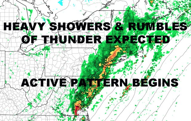
For tomorrow, expect the risk of showers and storms possible at any point during the day, but I think the heaviest action holds off until tomorrow night with a secondary wave forming along the front; something I spoke about yesterday in terms of possibility. This wave will enhance the steady rain, heavy at times, and more rumbles of thunder through the night. It'll also help keep the clouds around for Saturday as things will be stubborn to fully move out in a timely manner.

Your weekend is looking like a split, with a few lingering showers Saturday morning, then lingering clouds into the afternoon; partial clearing late with highs in the low to mid 50's. Sunday is looking like a perfect day aside from the temps. The sun won't do much as we'll head back into a seasonably cool low to mid 50's.

As another system behind to approach the area, it'll give us a sunny start Monday, then increasing clouds; highs in the mow to mid 50's. Then we play the game again with front-related "warmth". I use the quotes to denote relative warmth, not actual warmth. Our approaching system with help get us back to normal and then slightly above normal mid-week, but nothing mind-blowing by any means.
So rain moves back in for early to mid next week, and I'm keeping an eye on something much more substantial possible for the follow weekend and to start off mid-November. Areas upstate in mid-November could see their first taste of teens.
FiOS1 News Weather Forecast For New Jersey
FiOS1 News Weather Forecast For Hudson Valley
NATIONAL WEATHER SERVICE SNOW FORECASTS
JOIN JOESTRADAMUS ON YOUTUBE!
LATEST JOESTRADAMUS ON THE LONG RANGE
Posted from my blog with SteemPress : https://www.nycweathernow.com/nyc-showers-storms-welcome-weekend-active-pattern-begins/