Quick Period Of Departing Light Snow Possible As You Go East
Quick Period Of Departing Light Snow Possible As You Go East
Good morning everyone. We have a sunny start this morning as we have a tiny window of clear skies over us. Clouds are to our east, west, south, and north, so don't expect this nice moment to last long. Those clouds are from our gathering system, that'll mostly miss us aside from some fringe rain and maybe even some departing snow the further east you go.
SATELLITE

Moisture passing to our south and low pressure sinking down from the Great Lakes, will combine well offshore of our area today and tonight. That'll make for a vigorous, but compact, system pulling away. Clouds will increase, northeast winds will pick up, and temps will drop as sunshine fades away and the ocean influence takes over.
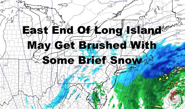
We'll have some afternoon rain, but nothing crazy. I've also talked about the possibility of wet snow mixing with rain briefly as everything departs, even when other outlets took that equation out. I still believe this is a possibility, but there's also the possibility of a full changeover briefly in Suffolk County; especially eastern Suffolk by the forks and south-facing shores.
Unless there are any surprises, I don't believe this will amount to much if anything at all. Dropping temps, low enough temps, would have to coincide with heavy-enough snow to cover wet surfaces. This is why I'm thinking a coating at best, to nothing at all. We'll be keeping an eye on the radar overnight to see if this scenario even plays out.

Tomorrow remains looking breezy and chilly, with decreasing clouds and steady northerlies. Highs will be in the low to mid 40's.
Mild air comes back Sunday, and westerlies will help push 55-60 degree temps all the way to the shores expect the shorelines of eastern Long Island.

Monday continues to be the best day, with sunshine and 60-65 degree temps. Depending on the final sunshine and wind profile, a few spots, especially just west of NYC, could notch past 65 and towards/near 70.
Tuesday isn't that bad, and rain looks to hold off till late. Expect morning sun, afternoon clouds, and highs in the upper 50's to near 60.

Please note that with regards to any tropical storms or hurricanes, should a storm be threatening, please consult your local National Weather Service office or your local government officials about what action you should be taking to protect life and property.
Posted from my blog with SteemPress : https://www.nycweathernow.com/quick-period-of-departing-light-snow-possible-as-you-go-east/