Using Strava Heatmaps to find cycling routes
Hello all, in continuing my posts on cycling routes, this time will be mostly focused on the road bike. The Strava Heatmap site can be used to find shortcuts and alternatives to heavily traveled routes which usually have a lot of car traffic.
I generally ride routes that go through neighborhoods rather than streets that have high traffic volume because not only do the cars drive slower, there are fewer cars so the risk an accident with one is lower.
Cycling on the streets in the Bay Area CA is a percentage game, cycling with more cars increases your chances or percentage of getting into an accident with one. There are bike/car deaths practically every month in the Bay Area and from what I have seen, most of the accidents are on heavily traveled streets.
Here is the criteria for the Strava Heatmap site. The data is from the GPS 'tracks' from the users of Strava, more GPS tracks typically shows a brighter color.
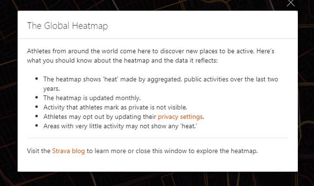
You can change the intensity of the heatmap as well as the color of the map. You can choose to see a specific sport like running, cycling or swimming.
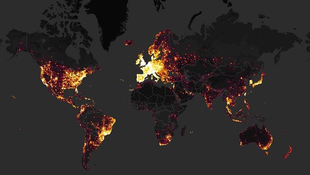
Below is a heatmap of the world for cycling, you can easily see the popularity by country. (That use a GPS device and Strava)
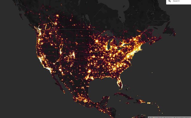
A shot of the USA
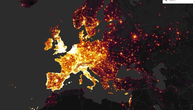
Europe
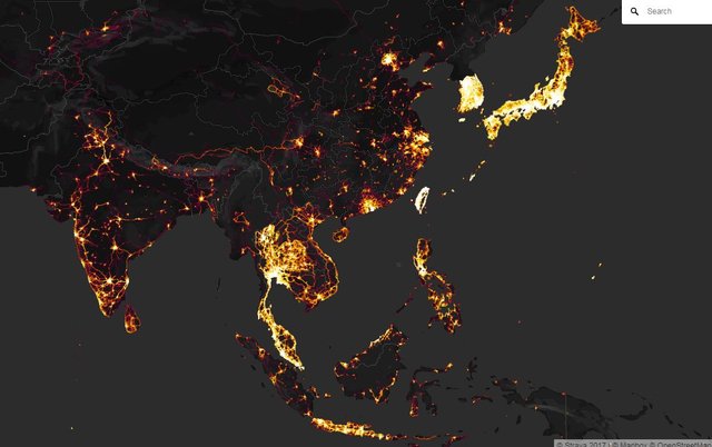
The far East
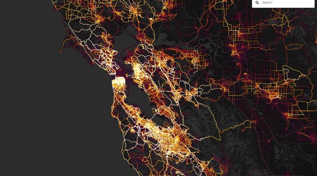
And where I'm at, the Bay Area, California
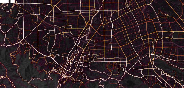
Here is a zoom in on the South Bay area, specifically Los Gatos, Saratoga, Campbell, South San Jose. You can search for new routes to ride and some streets that you may want to avoid due to car traffic.
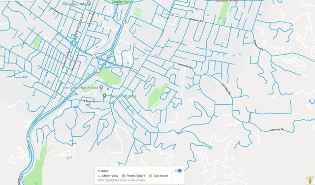
Another way to find potential routes is with Google Maps. There is a small 'man' icon at the bottom right side of the screen which you can click on which highlights the streets. This is another way to find short cuts and routes that are less traveled through neighborhoods.
Have fun searching for new cycling routes!
Nice information provided.Thanks for sharing the valuable information.
Wow... not only is this really useful, but the maps look super cool too!
A few years ago, I developed a cycling smartphone App to incentivize urban riding. Unfortunately, we were not able to get the project going for too long, but during those years we captured lots of rides and were able to create these animations through a collaboration with a data visualization expert. The video compresses in one minute a one month of rides participating in a city challenge to see which city area riders were cycling the most.
Pretty cool indeed! Nice work. Strava uses the GPS data from it's users and sells the information to cities that are interested in planning things like bike lanes and modifications to streets so it is safer. Your vid pretty much captures that.
Nice post! I'm using the heatmaps regularly because it's such a cool feature! You can also create a heatmap for your own activities, e.g. at the end of every year, print it and hang it on the wall as a sort self-made art....!
My cycling heatmap is in fact my desktop wallpaper!
This is cool, didn't know about it. Will check it out right now.
From the global heat maps, clearly Europe is winning the cycling war
Europe has a lot more history than the USA and it appears that do not rely on cars as much. (Lazy Americans...lol) Maybe their commute to work is short and can take a bike rather than a car? There is a huge distinction between south and north Korea. Japan apparently cycles a lot as well.
Hi @glennolua - I'm originally from the Netherlands and I can say that is correct. In my village, there's no point taking the car to go shopping, as this would take much longer and you struggle to find parking. We are not wearing helmets, and this helps to quickly hop on your bike to go somewhere (but of course it is already a safe cycling environment). And also, the shops are normally spread around in the main street, we don't have many shopping malls like for example in the US or here in SA. So it all makes sense to hop on a bike - oh yes: and there is no hill in sight, which also helps!
Speaking of Europe, I think that the populations within each country is also a bit more densely packed compared to the US. (Except for the major cities like San Francisco or NYC)
It appears that there is more of a cycling heritage in Europe as well. Teenagers are able to drive in the US at age 16 and being 'lazy', they would rather take a car with their friends to places rather than cycle. The distances are longer for sure and time is also a factor.
If you do look at San Francisco, there is a huge cycling community and it is similar to what you have mentioned above. The stores are down the street so you just have to go a mile or two.
Correct. It's all a combination of factors, and if you would want things to change, there are no silver bullets; (this is the same for most things in life, though). You have to create a culture of cycling, infrastructure, laws, etc etc. The Dutch Government at some point decided to put a lot of money in cycling infrastructure, making sure that it would be difficult to reach the city centers by car, and made sure that in case of an accident, a cyclist has a very strong position compared to a car driver. The very fast E-bikes currently on the road are a new phenomenon, and the Government struggles to come up with new regulations for these bikes.
But but but. Hills are what makes cycling interesting!
A interesting tip to remember when looking at these maps:
When you zoom in on a known popular climb, you can see that it is 'hot' which indicates a lot of riders, BUT it also has a lot more GPS data because the rider is riding much slower uphill. The Garmin's typically take one data point every second.
Ah, so the slower we go, the "hotter" we are? Interesting observation!
Japan is indeed the Asian leader. Thailand and Malaysia look good as well.
There is a lot of cycling in India as well, not on Strava though. Considering there are 12,500,000 units of cycles sold in the Indian market every year. Out of that huge number, only 30000 units of cycles are in the 350+ USD category. The majority of cycles sold here are in the sub-75 USD category.
Yeah, this is just what users have uploaded to Strava. There are some GPS users that are using another platform like mapmyride, etc... And probably many more users cannot afford a GPS unit or do not have a smartphone.