Adsactly Education - Missouri River
Adsactly Education: Missouri River
The Missouri River is the longest in North America running 2,341 miles (3,767 km) from it’s headwaters in Yellowstone park to it’s confluence with the Mississippi. The drainage basin for the Missouri is a significant fraction of the center of the US and Canada.
The Missouri is known as ‘the Big Muddy’ and it’s very character carries risks of catastrophic flooding and a lack of flow depending on he season. Of all the great rivers of the west it is probably most at peril due to global warming.
The River and It’s Course
Due to the way the Missouri was originally mapped, there is no definite headwaters. It officially begins at the confluence of three rivers, the Jefferson, the Gallitin and the Madison. The Madison begins just a few miles from the headwaters of the Snake in Madison Lake in Yellowstone National Park as the Firehole which flows east to the confluence.
The Gallatin runs out of Gallatin Lake in Yellowstone while the Jefferson rises up in the Rocky Mountains of Montana and joins the Beavrhead before the confluence of the three. By the time it is actually called the Missouri (at Missouri Headwaters State Park in Montana) it is already a pretty good sized river.
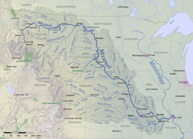
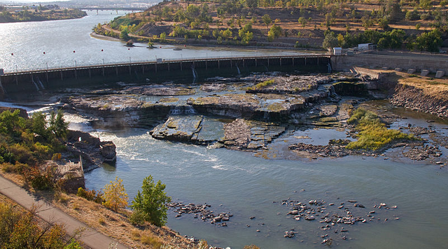
From the confluence the river flows northeast to Great Falls, Montana. It then flows generally east across the plains of Montana to North Dakota where the Yellowstone joins it from the southwest. The Missouri flows generally east through much of North Dakota before it turns southeast to run through South Dakota and into Nebraska. It forms the boundary between Nebraska and Iowa then between Kansas and Missouri. The river then flows east through Kansas City and on to St. Louis where it joins the Mississippi at the Missouri and Illinois border.
The Missouri drains an enormous watershed that totals over 500,000 sq. miles (1,300,000 sq. km) which is over five percent of the continent of North America. Though the population of the drainage area is only about 12,000,000 it provides a significant fraction of the grain, meat and fowl that feeds North America.
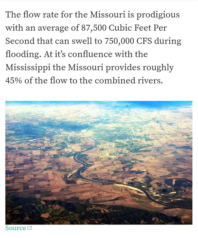
The flow rate for the Missouri is prodigious with an average of 87,500 Cubic Feet Per Second that can swell to 750,000 CFS during flooding. At it’s confluence with the Mississippi the Missouri provides roughly 45% of the flow to the combined rivers.
Geology
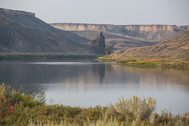
Around 50 million years ago the Rocky Mountains rose to form the western edge of a vast sea that covered the entire area between the Arctic Ocean and the Gulf of Mexico. The sediment from that sea forms much of the basis for the land that the Missouri drains. An uplift caused the sea to retreat and the area between the Rocky Mountains and the Appalachian Mountains became the home to many rivers and watercourses.
As the Rocky Mountains wore down a gentle tilt from west to east cast the character of the Great Plains. The Missouri drainage was probably split into three segments. The northern drained into Hudson’s Bay, the center and southern flowed toward what is now the Mississippi.
The ice ages changed the character of the river and the basin that we see today. As the ice ground down from the north the area was filled with huge inland lakes which spilled over making many of the dry watercourses that we see today. The end of the last ice age (roughly 15,000 years ago) marked the course of the current rivers.
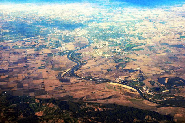
As the river and it’s tributaries flowed through the sediment that created the surface of the Great Plains it carried vast amounts of silt as it cut new channels through the plains and eventually carried all the way to the Gulf of Mexico and the Delta of the Mississippi.
History
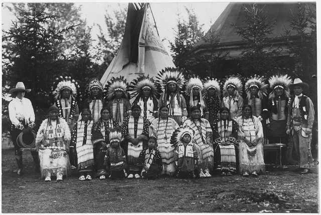
Almost as soon as the ice left (15,000 years ago) the people appeared. The silt that was carried downstream made huge flats of very rich soil that included a wide diversity of (edible) plants and American Bison by the millions. It is here, in the drainage of the Missouri and the Mississippi that North American agriculture began. Indigenous people soon learned to cultivate squash and corn and communities arose on a scale unseen in the rest of North America. A vast growing and trading network existed on the banks of the rivers.
Buffalo were numerous and provided the natives not only food but the hides provided clothing and even temporary shelter. Prior to the introduction of the horse, Buffalo hunting was a very cooperative process which generally involved herding a group of the foul tempered beasts into an enclosure or off a cliff. It was hard and dangerous but the rewards were mountains of good meat and leather. It required the work of many to get and store this resource which gave rise to the system of families, clans and tribes. Working together allowed all to eat and prosper.
.jpg)
.jpg)
Herbs and vegetables were numerous in the area so the diet was varied and rich. A rich diet and cooperative living led to a large population rise. More people and more time that was not needed just to be able to eat led to advanced tool making and art both practical and esthetic. Items of beauty were highly regarded and heavily traded. Tools and implements were prized possessions and the techniques for making them spread rapidly.
The natives had little written record so most of the information that we have today is from archeological findings and the records of the earliest European contacts. In the second part of this project we will explore the European expansion through the drainage of the Missouri River as well as the shape and form of the river today and how it got that way.
While the words and ideas in this post are strictly those of the author this source was referred to by me to insure numerical and historical accuracy.
Wikipedia: Missouri River
Unsourced Photos are used courtesy of the author.
Authored by: @bigtom13
Adsactly is a society for freethinking people. Interested? Click Here to join our Discord channel.

In the bottom of the page type in: adsactly-witness and select vote.

All small letters and without the @ sign
Or give us a direct vote here
Thank you!
Love that photo of the Indians in ceremonial dress. Any idea what year that was taken?
1928 in Dresden, Germany. I think one of my favorite authors is in that photo, but I can't prove it.
Thanks for the question. Always a pleasure.
Excellent photography
It's an amazing river and about the risks of catastrophic flooding the solution: Recognize the levies interfered with nature and even more so now with man made climate change and let the natural flow of river regain the natural growing of trees for food and other crops along the sides of the river. This saves lives, increases the great natural way of nourishing the land, and keeps the ocean clean. Of course curtailing the burning of so much fossil fuels and leaving most in the ground is the added safeguard to respect nature.
Oh, man. I hope nobody else reads your comment. That is a huge part of the second half of this piece.
Actually, very astute observation. We seem to continue to learn that the road to hell is indeed paved with good intentions. Thanks for reading and contributing.
😞! Comparing Missouri River with Mississippi River I can tell it’s a huge difference. As you mentioned “it’s a pretty good sized river.” Before reading your article, I didn’t know it was the longes river in North America, but now I do. I wonder how long it stays that way. It’s really interesting to read about the history and how the Missouri River has formed. At the end, this enormous river has been providing life to many for millions years. We should thought about and really appreciate what we still have until we don’t.
If the US were settled by whites from the west instead of the east it would be 4th longest in the world. What we know as the Yellowstone would actually be the headwaters and the Mississippi would flow into the Missouri rather than the other way round.
The Missouri is the absolute life of the great plains. I crossed it 8 or 10 times this summer, and it is really obvious being on the ground.
Thanks for the great comment.
The world the beauty of the world belong to Mighty god no one have certificat for the land no one take the land for their grave. we're all travelers. white people build the tall building & tenology, the beauty of the world made by Mighty god. Eygept onece in incient time phrown people lived there, now all is control by Arab people the king the president is Arabs. Missouri Riveris in Eygept land every generation come & dies but the world will be for ever & it was before our father Adam & our mother Eve no one brought license from Mighty god we dont live here for fantasy life we live for very short time wake up smell the beautiful rosses.
These stories were really unknown to me! I heard it first time. Thanks for shared this blog!
It really is a big river that drains a huge basin. The size of it all is just staggering.
This river name is The Missouri River is the longest waterway in North america. ascending inside the Rocky Mountains of western Montana, the Missouri streams east and south for two,341 miles three,767 kmb getting into the Mississippi River north of St. Louis, Missouri. The stream takes seepage from a with some restraint populated, semi-parched watershed of more than 1/2 a million rectangular miles (1,300,000 km2), which incorporates parts of ten U.S. states and Canadian areas. while blended with the lower Mississippi River, it administration the field's fourth longest waterway gadget. For more than 12,000 years, individuals have relied upon the Missouri River and its tributaries as a supply of sustenance and transportation. more prominent than ten most imperative organizations of nearby people populated the watershed, greatest principle a traveling way of life and relying upon noteworthy buffalo crowds that after wandered by means of the mind boggling Plains. the essential Europeans experienced the waterway in the late seventeenth century, and the area surpassed by means of Spanish and French arms sooner than at some point or another winding up some portion of the usa by means of the Louisiana buy. The Missouri turn out to be for quite some time accepted to be a piece of the Northwest Passage – a water course from the Atlantic to the Pacific – however when Lewis and Clark have turned into the first to venture to every part of the waterway's whole length, they affirmed the legendary pathway to be no more prominent than a legend...@adsactly
We here in the US tend to forget what a big deal 'the Northwest Passage' was in the late 18th and early 19th centuries. It seems so ludicrous now knowing that the Rocky Mountains stand in the way, but at the time the Rockies were completely unknown to the Europeans.
River is clearly the superior waterway. It's wider, deeper and did you notice how the Ohio's scour channel extends through the confluence point downstream? Don't think the Misorio will change names below Cairo any time soon, however. Anyway state of Misorio would have to become Ohio and that one is already taken...
Ahahaha. Yeah, Ohio got first pick. The rivers that run in from the east run over a lot more rock (rather than sediment) and tend to have deeper channels. Even without the man made impediments the Missouri can be awful wide and fairly shallow in places.
What a massive river is it has very interesting history pretty impressive information thanks for sharing @adsactly
Glad you liked it, it was a pleasure to write.
Wow! That looked absolutely amazing. I can’t even imagine how awesome that had to be. Absolutely breathtaking.
I rode my motorcycle across the entire drainage and back this summer. It is even more impressive when you are on the ground with it.