Touring Italy (#2): Exploring The Regional Natural Park of Portofino.
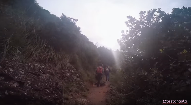
The heart of the promontory of Monte di Portofino can only be reached by following the dense network of paths that cross it.
About 80 km of paths wind over an area of just over 1,000 hectares, allowing you to visit the different locations of the park.
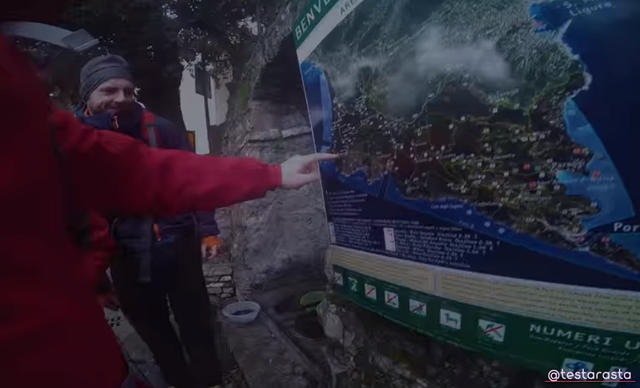
Starting from the main entrance doors (S.Rocco, Portofino Vetta, Nozarego, Portofino), reachable by public transport or by own means, you can take different itineraries, of varying length and difficulty, which cross the different areas of the park to reach the localities of Punta Chiappa, San Fruttuoso, Portofino, the main excursion destinations in the park.
On going.
They consist, for the most part, of ancient paths in paving or clay that were used to reach the places of religious worship (S.Fruttuoso, S.Nicolò, La Cervara), to connect the various inhabited nuclei and to reach the places of the rural work (olive groves, woods and charcoal burners, scrub and pastures).
The main axis of the park's path system is represented by the Portofino Vetta - Portofino mare route, which crosses the entire promontory from North-West to South-East.
From it, the different paths that lap and reach the coastal strip and the different nuclei depart.
Advancing along the paths, as you move away from the noise of city traffic, you gradually immerse yourself in the silence, smells and colors of the nature of the park, an uncontaminated island just a few tens of km from the metropolitan area of Genoa.
The path that starts from the churchyard of the parish church of San Rocco, is easy and panoramic, allows you to undertake other routes and takes place along the western side of Monte di Portofino.
A variety of landscapes between vegetation and limestone.
The flat mule track crosses the towns of Poggio and la Mortola, suggestive with its "trompe l'oeil" decorations and along the way the spontaneous vegetation alternates with the crops and the conglomerates of Portofino replace the limestones of Monte Antola offering a variety of panoramas and particularly appreciable landscapes.
The first stretch of road allows you to admire a large part of the western Ligurian coast and the Golfo Paradiso, up to Genoa, bordered to the south by the thin rocky tongue of Punta Chiappa.
Here the life of man is still linked to that of the sea, as shown by the tonnara, the mufa and the fishing boats moored near the coast.
Olive groves, forest and Mediterranean vegetation.
Always towards the south you can observe the aspect of the vegetation that you will meet later along the route: the olive groves near the inhabited nuclei, the Mediterranean vegetation (with prevalence of the holm oak mixed with respect to the pine forest of Aleppo pine on the ridges that descend to the sea), the mesophilic forest of black hornbeam and ash in the humid valleys that line the slope.
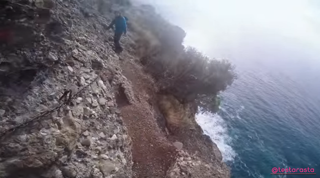
Below the path, the cliff coast plunges into the sea, the transparency of which often reveals the alternation on the bottom of areas occupied by the rocks precipitated along the slope and sandy areas spotted by the dark posidonia meadows.
Beyond the nucleuses of Poggio and Mortola, you advance through the cultivations, mainly olive groves, today largely abandoned, where it is possible to appreciate the flowering of showy plants such as the spadacciola, the anemone of the gardens and the narcissus in the cup.
After a bridge, some washrooms collect the water from the Vegia source, which flows into the area where the two types of rock on the Promontory come into contact.
Steep slopes, spontaneous vegetation, brambles and lianas.
The slopes are steep and steep divided into thin ridges and ridges notched by square rocky towers and due to the abandonment of the crops there is a recovery of spontaneous vegetation that replaces the olive trees now suffocated by brambles and lianas.
In short you reach the crossroads of Fornelli, at an altitude of 230 m, from where you can continue for Toca or Batterie.
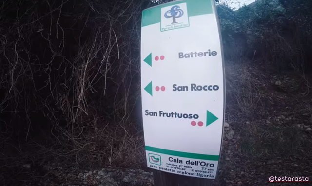
From the crossroads of Fornelli, at an altitude of 230 m, which going down leads to the Batterie, go up to the left, entering a sparse pine forest with pine trees, under which the main elements of the Mediterranean maquis grow.
In the narrow, fresh and humid valleys, the ash-trees, the black hornbeams and other submontane and mountain species go near the sea, helped by the favorable environment.
On the route, among remarkable panoramic hints on Punta Chiappa and Camogli, the rare spatulate saxifrage, the smilax or stracciabraghe, the wild madder from whose roots extracted alizarin, a red coloring substance, today produced synthetically, make a fine display. On the trunks and on the pavement the seals of the presence of the wild boar.
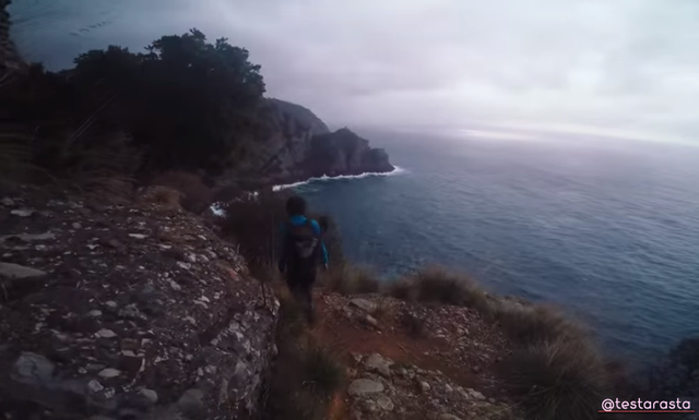
Splendid panoramic view of the sea.
The path ends in Toca, passing through a shady forest, among numerous hazel trees.
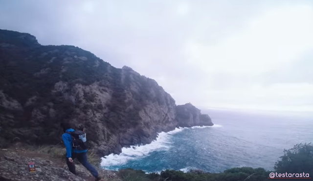
The scenic and suggestive route crosses the entire Cala d'Oro and the western part of the San Fruttuoso cove at the top, maintaining the average altitude of 450 m.
From the locality Toca which is located on the watershed that descending from the summit of the Promontory, through Monte Tocco (543 m), delimits the Cala dell'Oro to the west, the path that offers a splendid panoramic view of the sea that sweeps from the Tino Island at Capo Mele.
The route develops in the Portofino conglomerate: the fractures that cross it are clearly visible, originating saddles and towers.
Just before climbing some rock steps, you can glimpse, a few meters above the path, a small source which, like the others, is the reference point for reptiles (lizards, geki, lizard, snakes) and small birds in the area.
Then, continuing on the way, you reach the valley of the Cala dell’Oro mainly covered by the Mediterranean scrub and you cross the hidden kingdom of the herring gull, the peregrine falcon and during the period of passage, the egrets and the other migratory birds. You get to a gully and go up to another point where you can see San Fruttuoso di Capodimonte from a particularly panoramic point of view.
The shape of the inlet is identical to that of Cala dell'Oro having the same geological history. Around it, the rocky slopes descend steeply into the sea where they already maintain a few meters from the coast, seabeds that present interesting variations of flora and fauna.
Go up along the sunny side of the ridge which, descending from the summit, delimits the two inlets of San Fruttuoso and Cala dell’Oro. Following numerous fires, the bracken and bramble now replace, with intrusive arrogance, the shrubs that previously made up the Mediterranean maquis where the pine forest was more open.
The area to be traveled is characterized by long periods of insolation and therefore by high average temperatures even in winter and the rocky ridge that descends steeply into the sea is beaten by the winds that come from the southern quadrants.
In the last stretch, you leave the arid area of the Mediterranean scrub and cross the cool and shady environment of the forest, until you reach the Pietre Strette locality, one of the main crossroads of the park.
The easy and winding pedestrian road that goes down to San Fruttuoso represents the shortest connection between the Borgo and Camogli or Santa Margherita if the sea conditions prevent the landing of the boats. The environment is fresh and humid, consisting of a mixed wood of holm oak, black hornbeam and downy oak, poorly lit, very different from the remaining side, burned by the sun and beaten by the southern winds.
The valley that you are crossing owes its origin to a deep incision of the rock, aligned in a north-south direction, formed during the lifting and settling movements of the conglomerate.
The environment under the foliage of the trees remains fresh and shady in every season thanks to the evergreens that make up the tree layer and prevent a strong insolation of the soil that would make the water evaporate.
The undergrowth, therefore, is rather sparse and characterized only by some species such as the butcher's broom and the ivy. The path turns and leaves the valley to lead along the sunny slopes facing south and impoverished in the past by repeated fires, arriving at a water tank. In this area, called the Caselle, the water from five springs is collected and subsequently conveyed, through a small aqueduct, to San Fruttuoso.

The presence of water even on the driest slopes and in periods of summer drought is not unusual on the Promontory where the conglomerate. Through the fractures, the rock captures almost all of the rainwater inside, favoring the underground flow rather than the superficial one, always rather ephemeral.
As you go further down, you will notice the first bands and, all around, you can guess that the morphology of the area has been changed by the intervention of the man who has terraced the slopes to moderate their slopes, otherwise unsuitable for cultivation.
In the memory of the old remains the memory of collections that the olive groves of this area, magnificently exposed, allowed; of the cut of the fishbone (ampelodesma), for hunger nets and baskets and of the gigantic red junipers.
Of the latter species, whose compact wood was highly sought after for cabinet-making works, it remains a splendid specimen in the woods just before entering San Fruttuoso.
In the approach to the lower valley meet the abandoned houses, old bands whose dry walls are composed only of conglomerate blocks of various sizes, olive trees that bear the traces of the fire and from whose stumps throw numerous suckers, old crops and traces of ancient paths that get lost in the bush.
Where the water reaches, plants such as reed and numerous types of fern flourish, and many animals like the green lizard, the rat snake and numerous birds find a point of reference. After crossing a small holm oak, you will pass some splendid specimens of domestic pine reaching the sixteenth-century tower of the Doria, built to defend the Moorish incursions, home to the primary school since 1880 and hour of FAI initiatives
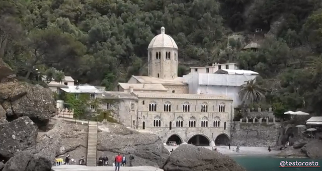
Going down to the beach you will discover a spring behind the last arches of the Abbey.
The old Abbey of San Fruttuoso.
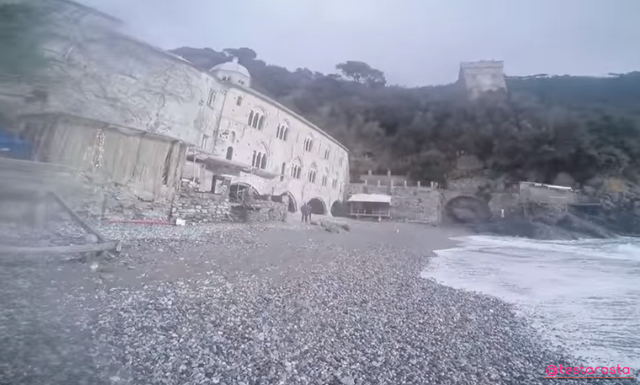
It is no coincidence that it is located along the gully where the Caselle springs flow and in whose depth water flows and collects.
A visit to the Monumental Complex is a must.
Sources.
Regional Natural Park of Portofino.
![]()

View this post on TravelFeed for the best experience.
@tipu curate 2
Upvoted 👌 (Mana: 6/18 - need recharge?)
@magicmonk @tipu Thanks for the support received!
Regards.
Congratulations @testarasta! You received the biggest smile and some love from TravelFeed! Keep up the amazing blog. 😍 Your post was also chosen as top pick of the day and is now featured on the TravelFeed.io front page.
Thanks for using TravelFeed!
@wanderein (TravelFeed team)
PS: Have you joined our Discord yet? This is where over 1000 members of the TravelFeed come together to chat. Join us!
amaaazing place