🚨 TROPICAL DEPRESSION SIXTEEN (CARIBBEAN SEA)
BULLETIN
Tropical Depression Sixteen Advisory Number 1
NWS National Hurricane Center Miami FL AL162017
1100 AM EDT Wed Oct 04 2017
...NEW DEPRESSION FORMS IN THE SOUTHWESTERN CARIBBEAN SEA...
...TROPICAL STORM WARNING ISSUED FOR PARTS OF CENTRAL AMERICA...
SUMMARY OF 1100 AM EDT...1500 UTC...INFORMATION
LOCATION...12.2N 81.9W
ABOUT 25 MI...40 KM SSW OF SAN ANDRES ISLAND
ABOUT 210 MI...340 KM SSE OF CABO GRACIAS A DIOS ON NIC/HON BORDER
MAXIMUM SUSTAINED WINDS...35 MPH...55 KM/H
PRESENT MOVEMENT...NW OR 305 DEGREES AT 7 MPH...11 KM/H
MINIMUM CENTRAL PRESSURE...1005 MB...29.68 INCHES
WATCHES AND WARNINGS
CHANGES WITH THIS ADVISORY:
The government of Nicaragua has issued a Tropical Storm Warning for
the coast of Nicaragua from Sandy Bay Sirpi northward to the
Honduras border.
The government of Honduras has issued a Tropical Storm Warning for
the coast of Honduras from Punta Castilla eastward to the
border with Nicaragua.
SUMMARY OF WATCHES AND WARNINGS IN EFFECT:
A Tropical Storm Warning is in effect for...
- Sandy Bay Sirpi Nicaragua to Punta Castilla Honduras
A Tropical Storm Warning means that tropical storm conditions are
expected somewhere within the warning area, in this case within 24
hours.
Interests elsewhere in Honduras, the Bay Islands, western Cuba and
the Yucatan Peninsula should monitor the progress of the depression.
For storm information specific to your area, please monitor
products issued by your national meteorological service.
DISCUSSION AND 48-HOUR OUTLOOK
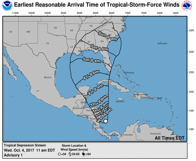
At 1100 AM EDT (1500 UTC), the center of Tropical Depression Sixteen
was located near latitude 12.2 North, longitude 81.9 West. The
depression is moving toward the northwest near 7 mph (11 km/h) and
this motion is expected to continue today. On the forecast track,
the depression should be nearing the coast of Nicaragua early
Thursday, move across northeastern Nicaragua and eastern Honduras
late Thursday, and emerge into the northwestern Caribbean Sea on
Friday.
Maximum sustained winds are near 35 mph (55 km/h) with higher gusts.
The depression is expected to become a tropical storm later today
or tonight.
The estimated minimum central pressure is 1005 mb (29.68 inches).
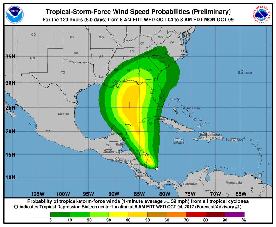
HAZARDS AFFECTING LAND
RAINFALL: Rainfall amounts of 15 to 20 inches are expected across
portions of Nicaragua, with isolated maximum amounts of 30 inches
possible. Across Costa Rica and Panama, 5 to 10 inches of rain are
expected, with isolated maximum totals of around 20 inches possible.
Across Honduras, rainfall amounts of 2 to 5 inches, with isolated
maximum amounts of 8 inches are expected. This rainfall could cause
life-threatening flash floods and mudslides.
WIND: Tropical storm conditions are expected to start in the
warning area in Nicaragua early on Thursday, and spread into
Honduras late Thursday.
NEXT ADVISORY
Next intermediate advisory at 200 PM EDT.
Next complete advisory at 500 PM EDT.

@reported has voted on behalf of @minnowpond. If you would like to recieve upvotes from minnowpond on all your posts, simply FOLLOW @minnowpond. To be Resteemed to 4k+ followers and upvoted heavier send 0.25SBD to @minnowpond with your posts url as the memo