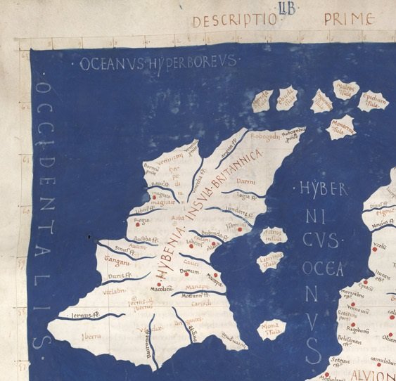
Ptolemy’s Map of Ireland – Part 8
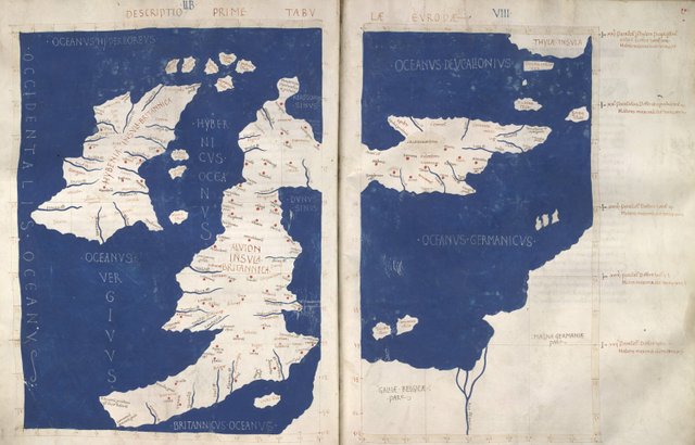
Claudius Ptolemy’s map of Ireland comprises a list of forty geographical features, together with their latitudes and longitudes, and the names and approximate locations of twenty tribes. These sixty items fall into the following categories:
- 5 Promontories or headlands
- 15 River mouths or estuaries
- 11 Towns or settlements
- 9 Offshore islands
- 20 Tribes
Many people before me have hazarded guesses as to the identities of these places and peoples. Some of these guesses are more educated than others. The sources I consulted include the following:
- Karl Wilhelm Ludwig Müller: Klaudiou Ptolemaiou Geographike Hyphegesis (1883)
- Friedrich Wilhelm Wilberg: Claudii Ptolemaei Geographiae, Libri Octo: Graece et Latine ad Codicum Manu Scriptorum Fidem Edidit Frid. Guil. Wilberg (1838)
- Karl Friedrich August Nobbe: Claudii Ptolemaei Geographia (1845)
- Goddard H Orpen: Ptolemy’s Map of Ireland (1894)
- T F O’Rahilly: Early Irish History and Mythology (1946)
- J J Tierney: The Greek Geographic Tradition and Ptolemy’s Evidence for Irish Geography (1976)
- J F Killeen: Ireland in the Greek and Roman Writers (1976)
- John Waddell: The Prehistoric Archaeology of Ireland (2000)
- Robert Darcy & William Flynn: Ptolemy’s Map of Ireland: A Modern Decoding (2008)
I have relied mostly on Müller, whose edition is generally considered the best (for Ireland, at least). But it is not perfect:
Another edition was begun in 1883 by C. Müller, with a second (and final) volume published in 1901, after Müller’s death, under the supervision of C.T. Fischer. This edition presents the text, with apparatus and notes, only as far as the end of Book 5. Müller used numerous manuscripts, including most of those discussed above (excepting U and K). An inadequate classification of the manuscripts resulted in a cumbersome apparatus, citing readings from unimportant copies while omitting many important variants in the principal ones. Nevertheless, Müller’s remains the best available critical text for Books 1 through 2.6, and 3.2 through 5 (Berggren & Jones 52)
Of the extant manuscripts, X is believed to preserve the oldest version of the text: this is probably the closest we will ever get to Ptolemy’s autograph. This manuscript is housed in the Vatican Library, but it has been digitized and is available for viewing online: Vaticanus graecus 191 fol. 127-172. The description of Ireland is on folia 138v–139r.
Some Assumptions
In an earlier article I mentioned some of the assumptions I made regarding Ptolemy’s method of working and regarding the nature of his sources (which he rarely identifies). These are merely speculations, and they can be boiled down to the following four:
At best, Ptolemy’s sources located a particular landfall by giving its general direction from another location (N, S, E, W, NE, SE, SW, NW) and the number of days or half-days of sailing required to reach it.
Ptolemy worked with a Cartesian grid comprised of meridians of longitude and parallels of latitude spaced at intervals of 5' of arc. Each one of his Irish locations is situated at an intersection point on this grid.
Ptolemy believed that in the vicinity of Ireland, the distance between parallels of latitude 5' apart was 41⅔stadia or about 7.7 km, while the distance between meridians of longitude 5' apart was only half this distance: 20⅚ stadia or about 3.85 km (Ptolemy 1:7:1).
Ptolemy’s geography of Ireland describes the island as it was around 325 BCE, as T F O’Rahilly argued more than seventy years ago (O’Rahilly 1-42). This is almost half a millennium before Ptolemy’s time.
In the previous article I also made the rough estimate that for Ptolemy a ship sailing along the coast of Ireland could cover between 100 and 400 stadia in half-a-day, or an average of about 250 stadia. In round metric values, this is approximately 20 to 80 km, or an average of 50 km. This corresponds roughly to speeds of 2-6 knots (averaging 4 knots) with 6-7 hours of sailing in half-a-day.
I also pointed out in the previous article that Ptolemy made some simple errors in his original data when describing countries within the Roman Empire. For example, he plotted some locations in Iberia in the wrong order (Defaux 349). Errors of this sort probably also crept into his description of Ireland, a remote and little-known place, which was never part of the Empire and which lay at the end of the known world. Any interpretation that does not reflect this is surely flawed.
Expectations
Before we even begin to try and identify Ptolemy’s locations with actual geographical markers on the ground, we should ask ourselves what it is that we expect to find in his description. For example, Ptolemy’s map includes fifteen rivers (or, more precisely, river mouths). It is only to be expected that these include all the major rivers of Ireland. It would be strange, for example, if Ptolemy had omitted Ireland’s longest river, the Shannon, but had included a comparatively insignificant stream, such as the Poddle.
Similarly, his five promontories are more likely to include the extreme points of the island—the most northerly point, the most southerly point, etc—than intermediate headlands.
Ptolemy’s Rivers
In primary school, when I first studied the geography of my native land, we were encouraged to draw maps of Ireland by hand and fill in the principal geographic features. Here is a map of Ireland with the rivers I remember learning about as a child:
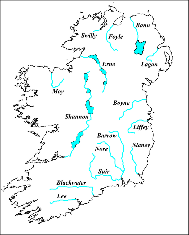
- Swilly
- Foyle
- Bann
- Lagan
- Boyne
- Liffey
- Slaney
- Barrow-Nore-Suir
- Blackwater
- Lee
- Shannon
- Moy
- Erne
Ptolemy has fifteen rivers entering the sea, whereas my map has only thirteen. I would have been surprised to learn that Ptolemy had omitted any of these thirteen, but his map has only two rivers on the north coast, while mine has three! The mouths of the Swilly and the Foyle are separated from the coastal waters proper by extensive loughs, so perhaps Ptolemy has omitted one or both of these.
His map has five rivers on the east coast, whereas mine has only four. I have three rivers on the south coast, while Ptolemy has only two. And he has six on the west coast, while I have only three.
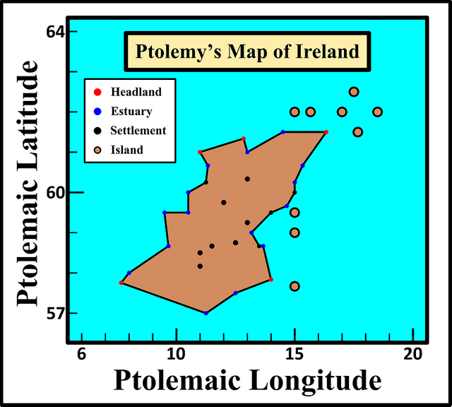
Ptolemy’s Headlands
What about Ptolemy’s headlands? We can almost immediately identify four of these. Only the south-western promontory is of doubtful identity. There is also the question of the island's southernmost point, which is not listed among Ptolemy’s promontories.
Ptolemy’s Towns
Ptolemy’s towns or settlements present us with a unique challenge. Today, it is even questioned whether there were any towns as such in ancient Ireland. I accept T F O’Rahilly’s argument that Ptolemy’s Geography preserves a description of Ireland as it was around 325 BCE, long before Ptolemy’s time. It is highly unlikely that there were any towns in Ireland in that era, when the island was still only sparsely populated. So what is Ptolemy describing? Strongholds or fortresses of local rulers? Meeting places where trade took place? This is a conundrum to which we will return in a later article.
Ptolemy’s Islands
Ptolemy’s nine Irish islands represent a special class of geographical objects that should be distinguished from his thirty-one locations on the mainland of Ireland. As O’Rahilly noted:
Ptolemy names nine islands in all, but only two or three of these can be regarded as properly belonging to Ireland. (O’Rahilly 2, fn)
Like his towns, Ptolemy’s islands also represent a special case to be dealt with separately.
To be continued ...
References
- Olivier Defaux, The Iberian Peninsula in Ptolemy’s Geography: Origins of the Coordinates and Textual History, Edition Topoi / Exzellenzcluster Topoi der Freien Universität Berlin und der Humboldt-Universität zu Berlin, Berlin (2017)
- J Lennart Berggren, Alexander Jones, Ptolemy’s Geography: An Annotated Translation of the Theoretical Chapters, Princeton University Press, Princeton NJ (2000)
- Lionel Casson, Ships Under Sail in the Ancient World, Transactions of the American Philological Association, Volume 82, pp136‑148, The Johns Hopkins University Press, Baltimore, Maryland (1951)
- Otto Cuntz, Die Geographie des Ptolemaeus: Galliae, Germania, Raetia, Noricum, Pannoniae, Illyricum, Italia, Weidmann, Berlin (1923)
- Robert Darcy & William Flynn, Ptolemy’s Map of Ireland: A Modern Decoding, Irish Geography, Volume 41, Number 1, pp 49-69, Geographical Society of Ireland, Taylor and Francis, Routledge, Abingdon (2008)
- J F Killeen, Ireland in the Greek and Roman Writers, Proceedings of the Royal Irish Academy: Archaeology, Culture, History, Literature, Volume 76, pp 207-215, Dublin (1976)
- Karl Wilhelm Ludwig Müller (editor & translator), Klaudiou Ptolemaiou Geographike Hyphegesis (Claudii Ptolemæi Geographia), Volume 1, Alfredo Firmin Didot, Paris (1883)
- Karl Friedrich August Nobbe, Claudii Ptolemaei Geographia, Volume 2, Karl Tauchnitz, Leipzig (1845)
- Thomas F O’Rahilly, Early Irish History and Mythology, Dublin Institute for Advanced Studies, Dublin (1946)
- Goddard H Orpen, Ptolemy’s Map of Ireland, The Journal of the Royal Society of Antiquaries of Ireland, Volume 4 (Fifth Series), Volume 24 (Consecutive Series), pp 115-128, Dublin (1894)
- Claudius Ptolemaeus, Geography, Biblioteca Apostolica Vaticana, Vat Gr 177
- J J Tierney, The Greek Geographic Tradition and Ptolemy’s Evidence for Irish Geography, Proceedings of the Royal Irish Academy: Archaeology, Culture, History, Literature, Volume 76, pp 257-265, Royal Irish Academy, Dublin (1976)
- John Waddell, The Prehistoric Archaeology of Ireland, Wordwell Ltd, Bray (2000)
- Friedrich Wilhelm Wilberg, Claudii Ptolemaei Geographiae, Libri Octo: Graece et Latine ad Codicum Manu Scriptorum Fidem Edidit Frid. Guil. Wilberg, Essendiae Sumptibus et Typis G.D. Baedeker, Essen (1838)
Image Credits
- Ptolemy’s Map of Ireland and Britain: Wikimedia Commons, Francesco di Antonio del Chierico (artist), Public Domain
- Ptolemy’s Rivers of Ireland: Wikimedia Commons, Francesco di Antonio del Chierico (artist), Public Domain
- The Principal Rivers of Ireland: Self-Made, Kopimi
- Ptolemy’s Map of Ireland: Self-Made, Kopimi

Hello, good friend, thank you for sharing those good works of JAMES JOYCE, they are excellent, I love them, I wish you greetings.
Great publication. Thanks for sharing us.
educational post for history students, Those who cannot learn from history are doomed to repeat it. Excellent post @harlotscurse Thank you and wish you all the best, thumbs up
great post on ireland history thanks for sharing
informative post @harlotscurse
you are so much informative...you learn me a lot..thank u.. @harlotscurse
@upvote done
Great publication my friend, where he points out the geographical location of Ireland
thats great &thanks for sharing
@upvote done
Hello dear friend @harlotscurse .. How are you? .. dear you very well post
Wow, a very good informative post. Keep posing like this such, an educational one