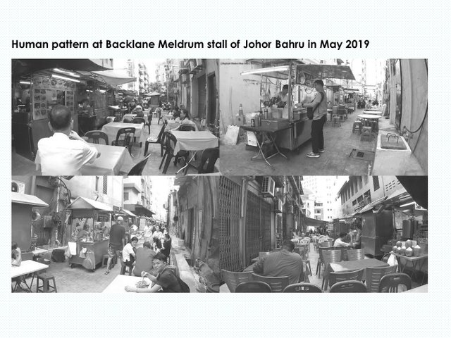
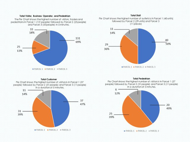
Human pattern at Backlane Meldrum stall of Johor Bahru in 2019
I would like to share on the necessity of creating human stationary snapshot or mapping before the spark of any future design idea. Human stationary snapshot or static snapshot could resemble the real connection of human with the environment and also human to human with the environment. Movement of human only display the economic connectivity but not really the human life or its place making. This is my real interpretation of creating placemaking or my kind of understanding placemaking. Placemaking could happen anywhere but it should be defined by the exact time, culture and location with relation with economy. Not by the economy but with the economy. Hence, understanding static activities of people is the real vital. Researcher or observer is needed to perform data collection on site for at least more than a week and not be based on any influences, politics, self-interest or and future economic plan biases. So please, watch humans slowly, carefully and intimately. This has been embodied in my personality for more than 5 years, for now. So what is Placemaking? is it Static Activities?
Static snapshot method records the use of public’s stationery pattern of spaces within buildings and public squares at one snapshot moment (Mahdzar 2008, Gehl & Svarre 2013). In this method the precise location and if of interest activity is recorded on the plan. The observer walks from space to space and takes a mental snapshot of the activity precise now at which the space was observed (T Grajewski, L Vaughan 2001). The snapshot is then recorded on the plan, with coding according to activity. Using the rules of convex break-up to segment space into smaller parts in applying the data on during spatial analysis. Regarding the snapshot’s perimeter, Ghel mentioned that we usually recognize a person at somewhere between 50 and 70 meters. Body language can also be read from this distance. And at the distance of about 22 – 25 meters, which is the distance between the longer sides of the plaza, we can accurately read facial expression and dominant emotions (2010:34).
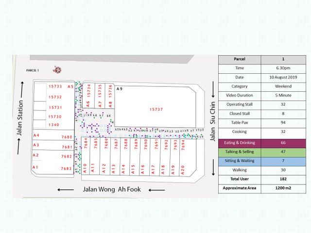


I have improvised the previous method by adopting the usage of action camera attached to my body, the observer. The duration of 5 minute video walkthrough was translated into a single piece of static snapshot.
This is a collaborative research work with Arr Studio and K.Halim Architect for MBJB, Majlis Bandaraya Johor Bahru (Johor Bahru City Hall), Malaysia
by Amirul Hakim Jamil.
References:
- Mahdzar, Sharifah Salwa Binti Syed. Sociability vs accessibility Urban street life. University of London, University College London (United Kingdom), PhD Thesis 2008.
- Gehl, J., & Svarre, B. (2013). How to study public life. Island press.
- Grajewski, T., & Vaughan, L. (2001). Space syntax observation manual. UCL Bartlett and Space Syntax Limited, London.
- Gehl J (2010) Life between Buildings, Using Public Space, The Danish Architectural Press, Copenhagen.
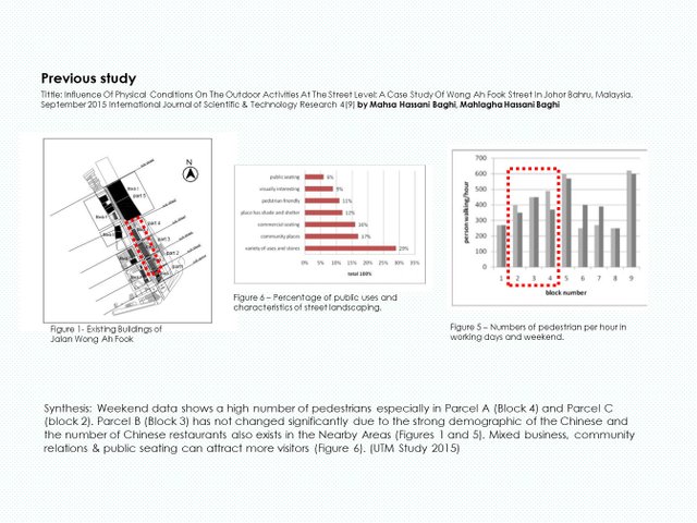
- Mahsa Hassani Baghi, Mahlagha Hassani Baghi (2015), Influence Of Physical Conditions On The Outdoor Activities At The Street Level: A Case Study Of Wong Ah Fook Street In Johor Bahru, Malaysia. September International Journal of Scientific & Technology Research 4(9).
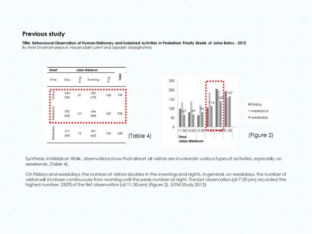
- Amir Ghahramanpouri, Hasanuddin Lamit and Sepideh Sedaghatnia (2012) ,Behavioural Observation of Human Stationary and Sustained Activities in Pedestrian Priority Streets of Johor Bahru.
related post:
https://steemit.com/food/@pocketsociety/meldrum-walk-street-food