Hurricane Hector Passing South of Hawaii Tropical Storm Debby North Atlantic
Hurricane Hector Passing South of Hawaii Tropical Storm Debby North Atlantic
Hurricane Hector Passing South of Hawaii

Hurricane Hector is no making its closest pass to the southern tip of the big island of Hawaii where Tropical Storm Warnings are in effect. The land impacts to Hawaii are minimal if any and the hurricane will pass well south of the other islands by well over 200-300 miles. The main impact is to the coastal waters with winds and rough seas until the hurricane moves far enough to the west. Over the next few days Hurricane Hector is likely to cross the International Dateline and become Typhoon Hector when it does so. Weather models actually carry it pretty far to the west recurving east of Japan. We don't see this happen very often that a hurricane starts in the Eastern Pacific and manages to make it all the way across.
HURRICANE HECTOR SATELLITE LOOP

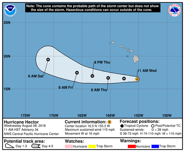
...MAJOR HURRICANE HECTOR PASSING SOUTH OF THE BIG ISLAND...
SUMMARY OF 1100 AM HST...2100 UTC...INFORMATION
LOCATION...16.5N 155.3W
ABOUT 220 MI...355 KM S OF HILO HAWAII
ABOUT 370 MI...600 KM SSE OF HONOLULU HAWAII
MAXIMUM SUSTAINED WINDS...115 MPH...185 KM/H
PRESENT MOVEMENT...W OR 270 DEGREES AT 16 MPH...26 KM/H
MINIMUM CENTRAL PRESSURE...959 MB...28.32 INCHES
WATCHES AND WARNINGS
CHANGES WITH THIS ADVISORY:
The Tropical Storm Warning for Hawaii County has been
discontinued.
SUMMARY OF WATCHES AND WARNINGS IN EFFECT:
None.
Interests on Johnston Island should monitor the progress of Hector.
DISCUSSION AND OUTLOOK
At 1100 AM HST (2100 UTC), the center of Hurricane Hector was
located near latitude 16.5 North, longitude 155.3 West. Hector is
moving toward the west near 16 mph (26 km/h) and this general motion
is expected to continue through Thursday, with a gradual turn
toward the northwest expected Friday and Saturday.
Maximum sustained winds are near 115 mph (185 km/h) with higher
gusts. Hector is a category 3 hurricane on the Saffir-Simpson
Hurricane Wind Scale. Slight weakening is forecast during the
next couple of days.
Hurricane-force winds extend outward up to 35 miles (55 km) from the
center and tropical-storm-force winds extend outward up to 90 miles
(150 km).
The estimated minimum central pressure is 959 mb (28.32 inches).
HAZARDS AFFECTING LAND
SURF: Swells generated by Hector will bring large and dangerous
surf to portions of the main Hawaiian islands through tonight.
NEXT ADVISORY
Next complete advisory at 500 PM HST.

Meanwhile in the Atlantic Tropical Storm Debby has gained full tropical characteristics and is moving northward in the North Atlantic graveyard. Debby should be absorbed by a deepening trough to the north on Thursday.
...DEBBY MOVING OVER THE COLD WATERS OF THE NORTH ATLANTIC...
SUMMARY OF 500 PM AST...2100 UTC...INFORMATION
LOCATION...42.0N 47.2W
ABOUT 1100 MI...1770 KM WNW OF THE AZORES
MAXIMUM SUSTAINED WINDS...40 MPH...65 KM/H
PRESENT MOVEMENT...NE OR 40 DEGREES AT 15 MPH...24 KM/H
MINIMUM CENTRAL PRESSURE...1004 MB...29.65 INCHES
WATCHES AND WARNINGS
There are no coastal watches or warnings in effect.
DISCUSSION AND OUTLOOK
At 500 PM AST (2100 UTC), the center of Tropical Storm Debby was
located near latitude 42.0 North, longitude 47.2 West. Debby is
moving toward the northeast near 15 mph (24 km/h), and this motion
is expected to continue today and tomorrow.
Maximum sustained winds have decreased to near 40 mph (65 km/h)
with higher gusts. Debby is forecast to dissipate on Thursday.
Tropical-storm-force winds extend outward up to 60 miles (95 km) to
the southeast of the center.
The estimated minimum central pressure is 1004 mb (29.65 inches).
HAZARDS AFFECTING LAND
None.
Please consult your local National Weather Service office at weather.gov for the latest information on any tropical or storms or hurricanes that could be a threat to your area. Consult your local government officials regarding action you may need to take to secure life and property
FiOS1 News Weather Forecast For Long Island
FiOS1 News Weather Forecast For New Jersey
FiOS1 News Weather Forecast For Hudson Valley
NATIONAL WEATHER SERVICE SNOW FORECASTS
JOIN JOESTRADAMUS ON YOUTUBE!
LATEST JOESTRADAMUS ON THE LONG RANGE
Posted from my blog with SteemPress : http://www.meteorologistjoecioffi.com/index.php/2018/08/08/hurricane-hector-passing-south-of-hawaii-tropical-storm-debby-north-atlantic/