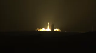
Last Delta II Rocket Launches NASA Satellite to Map Earth's Ice with Space Laser
"It's been a very, very prominent part of space history," said Scott Messer, program manager for NASA programs at ULA, during a pre-launch press conference Wednesday (Sep. 13). [In Photos: NASA's ICESat-2 Soars on Last Delta II Rocket]
"Wow," NASA launch director Tim Dunn said after the successful liftoff. "It was a thrilling day."
For its 155th and final mission, the Delta II flew in its 7420-10 configuration, outfitted with four Graphite Epoxy Motor (GEM) side-mounted boosters, which were jettisoned 1 minute and 22 seconds into the flight, and a 10-foot-diameter (3-meter) payload fairing, which was similarly disposed of about 4 minutes later as the rocket climbed into space. The Delta II's second stage engine completed the first of its four planned burns 11 minutes after liftoff, placing it into an initial elliptical transfer orbit.
The Delta II's second stage AJ10-118K engine reignited for 6 seconds about 47 minutes into the mission before deploying ICESat-2 into orbit. Twenty-three minutes later, the stage fired again to set up the release of four small satellites.
The tiny CubeSats were designed and built by UCLA, University of Central Florida, and Cal Poly to conduct research in space weather, changing electric potential and resulting discharge events on spacecraft and damping behavior of tungsten powder in a zero-gravity environment.
The final telemetry in Delta II history is expected about 2 hours after launch, sometime prior to the second stage impacting and sinking into the South Pacific Ocean.
Meanwhile, the ICESat-2 mission is getting underway.
"About an hour after we launch, the spacecraft separates from the launch vehicle and then about within the next 30 minutes the solar arrays deploy," said Doug McLennan, ICESat-2 project manager at NASA’s Goddard Space Flight Center in Maryland, on Wednesday.
The ICESat-2 spacecraft serves as a power and pointing platform for the mission's single instrument, the Advanced Topographic Laser Altimeter System, or ATLAS.
"We're not going to turn ATLAS on for about a week and then we're just checking it out. We don’t open up the [telescope] door for about another week. And then we start collecting early data from ATLAS, turn on the lasers and start our commissioning process," said McLennan, adding that the commissioning period will last about 60 days.
Once the science mission begins in earnest, ATLAS will begin directing 10,000 pulses of green light per second at Earth to record how long it takes some of those photons to bounce back. The transit time can be used to calculate ultra-precise elevation measurements from space, providing researchers with a map of changing ice levels and tree growth.
"We're going to have measurements all over and we're going to have them at much higher resolution, so we can do a much better job tying the change [in ice levels and forest growth] to climate overall," said Tom Wagner, ICESat-2 program scientist at NASA Headquarters in Washington, DC.
Editor's note: This story was updated at 11 a.m. EDT to note the successful post-launch engine burns to deploy ICESat-2 and the mission's Cubesats.
https://www.space.com/41850-nasa-icesat2-laser-launches-on-last-delta-ii-rocket.html?utm_source=notification
ALCHEMY MINING GROUP, INC
DIGITAL COIN PURPOSE
In support of our #greengoldmining initiatives and for the purpose of funding our Ecuador joint venture gold mining operations, we have created a Waves digital currency "AlchemyLGCoin"© utility token listed for trading operating on Waves – (DEX) decentralized exchange proof of stake, open market blockchain platform.
AlchemyLGCoin utility token digital currency is a negotiable title of ownership in a digital crypto form asset backed with Limited Edition gold coins crafted from responsibly processed gold ore mined and extracted from our Ecuador joint venture underground gold mine MINA SAN JUAN is live for Crowdfunding. 100% token bonus. Gold coins asset backed.

The processed ore is then crafted into 2,000 unique one-ounce (95%+ purity) Limited Edition collectible gold coins.
We own a 50% equity and board control of Alquimia y Explotación Minera San Juan Alquiexmi S.A., our joint venture Ecuador gold mining company with granted mineral rights on two gold mine concessions with operations on Bella Rica Codigo: 15 in the Bella Rica mining area, western Azuay province, municipality of Camilo Ponce Enríquez Ecuador.
Our Bella Rica Codigo: 15 concession has a running water stream and has been developed with buildings, equipment, operational facilities and being artisanally mined and exploited by our joint venture partner blasting a 1.3 Km main underground tunnel “MINA SAN JUAN” with 2 extensions extracting ore from 3 identified veins of 5 known veins producing gold balls and dores since 2012.
SYSTEMIC ENVIRONMENTAL PROBLEM
Environmental Impact of Artisanal Small-scale Gold Mining (ASGM) in Southern Ecuador is causing considerable environmental impacts, the most important of which are related to the discharge of metals, metalloids and cyanide into adjacent rivers.
The majority of Hg emitted by gold smelters being deposited within 1 km of the emission source contaminating the urban areas with a mix of lead, mercury, manganese, and various cyanides eventually flushed into the river system poisoning the water and killing all aquatic life in the area.
Responsible gold ore processing begins with our own gold ore mined from MINA SAN JUAN the Bella Rica mining district Camillo Ponce western Azuay province Rio de Oro Ecuador.
Instructions to participate: http://bit.ly/2Q47YHC
Donations
ETH: 0x0a7C095B430742D96C723aFd5daE1Ef0F6ee3408
BTC: 3BXNxbMX63P9CM36L4Fi9UTa9Uw35gNsKz
[WHITE PAPER] http://bit.ly/2LXdYyL
[REDDIT] https://redd.it/87v7tn
[TWITTER] http://bit.ly/2PzfmK3
[OFFICIAL ICO SITE] http://bit.ly/2CkHA9K
[MEDIUM] http://bit.ly/2Q47YHC
[FACEBOOK] http://bit.ly/2CrmVkj
[LINKEDIN] http://bit.ly/2LYWNfX
[MINA SAN JUAN]
[D.TUBE]
Thank You.