Beautiful Satellite Images of our planet #7: Satellite Paintings Edition!
In my series Beautiful satellite images of our Planet, I share some of my favourite images that have been taken by different satellites. I also try to provide a short explanation of what you see in the image and why it differs from what you would expect. Many of the comments I receive tend to mention how these images look a lot like paintings and I totally agree! However, some more closely resemble paintings than others. So, I thought I would put together of 3 images that I thought are really indistinguishable from art! I hope you’ll enjoy them :)
Dasht-e Kavir Desert, Iran
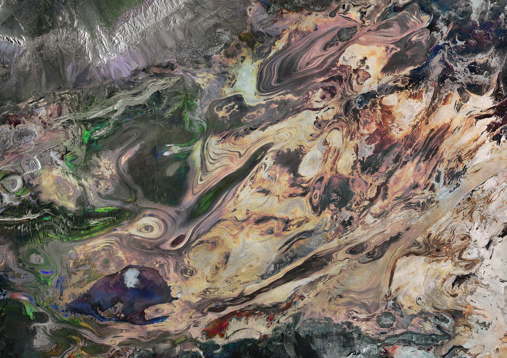
Radar Satellite image of the Dasht-e Kavir salt desert in southeast Iran taken by the European Sentinel-1 satellite image credit: ESA
You would be good to distinguish this one out from a selection of oil paintings! The many swirls and stark differences in colours make this picture one of my favourites. Unlike most images in my series, this is not an optical image but instead made out of compiling three different radar images taken over the same region. It combines three scans from Sentinel-1A’s radar on 21 January, 14 February and 9 March 2016, so about three weeks in between each image.
The image is a salt desert in southeastern Iran called Dasht-e Kavir. Those of you have read my previous posts might remember that salt deserts like these tend to accumulate different minerals over the years. The different colours, such as the vibrant blue, red and green seen primarily on the left half of the image, displays the changes that have occurred between the different data acquisitions during the three months. The strength of the colour reflects the size of the change, while each colour represents a different mineral.
To see what the area really looks like, you can compare it to this optical image taken 4 years earlier:
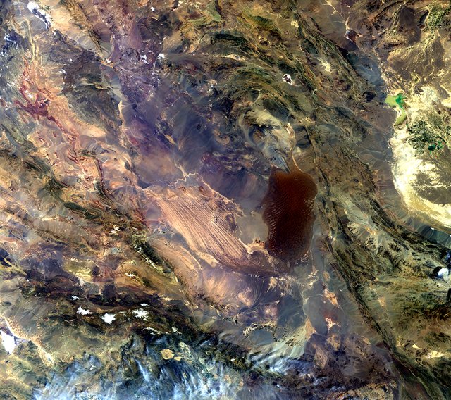
True colour optical image of the Dasht-e Lut salt desert in Iran taken by Envisat’s MERIS instrument on 2 April 2012
image credit ESA
Although the image does not cover the exact same region, you can still see the same salt dunes and mineral-rich ridges and furrows studied in the image above.
Earth-observing satellites are useful for finding and monitoring natural resources and minerals worldwide. This is especially the case for areas that are more remote and inaccessible than others. During the summer, temperatures in the desert can often reach 50 degrees Celsius, making it such an example.
A Plankton Bloom, Baltic Ocean
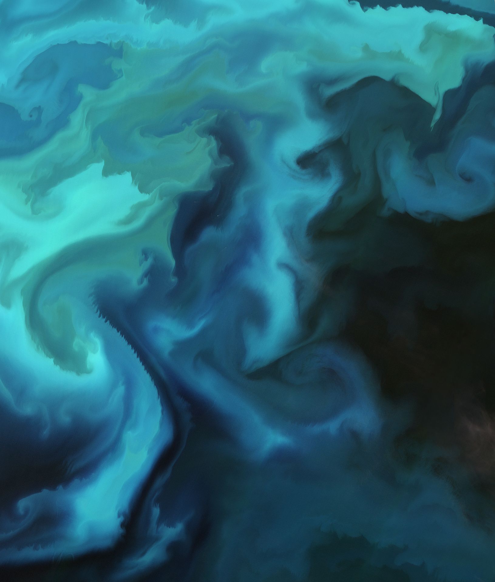
Natural colour image by the European Sentinel 2 Satellite of a plankton bloom in the Baltic Ocean
image credit: ESA
No one could fault you for mistakenly taking this satellite image of the Baltic Ocean to be a watercolour painting. Instead, this image taken by the European Sentinel 2A satellite is a completely natural-coloured optical image of a plankton bloom in the Baltic Ocean.
Since plankton is just as large a consumer of carbon as land-based plants, as well as the most basic component of the oceanic food chain, it is monitored routinely by satellites in order to observe changes over time. Indeed, the quantities and status of plankton at sea is also one form of data-input in climate-prediction models. Lastly, satellites are used to closely monitor and alert outbreaks of algae blooms due to their potential devastation of biodiversity and fishery resources. As the bloom exhausts the water of oxygen, fish may suffocate. Therefore, satellites are used to alert local fish farmers of harmful blooms as early as possible.
Although the phytoplankton floating on top of the waters which causes the bloom is too small to be individually seen, they occasionally get concentrated in one area. When these then produce chlorophyll for photosynthesis in sufficient numbers, it can colour the waters as seen in the satellite image above.
So, despite their potential negative impact on fisheries and biodiversity, no one can deny that they look beautiful from above! I’m sure that if you spend enough time looking at the image, you can make out shapes that resemble familiar shapes and beings.
Namib Naukluft Park, Nambia
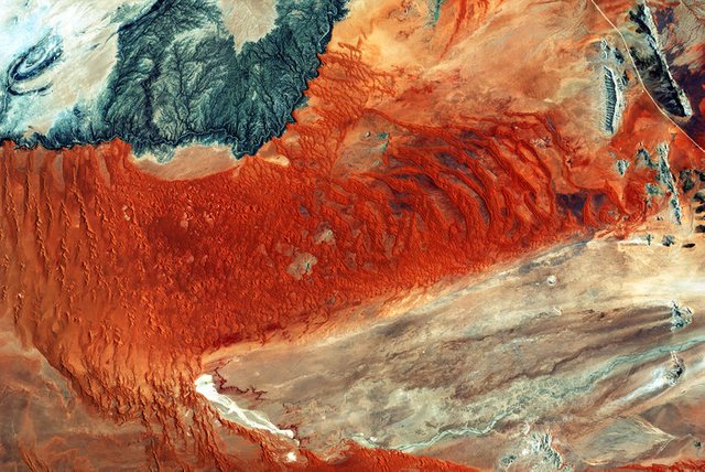
Optical image taken by the European Sentinel 2 satellite image of the Namib Naukluft Park in western central Nambia
image credit: ESA
What you see in this natural colour satellite image is the world’s oldest desert, the Namib, together with parts of the Naukluft Mountain range. The place sees no direct rainfall but instead receives water coming in as fog from the Atlantic Ocean. These winds also create the sand dunes visible throughout the image. Due to the fog carried by the wind, the iron left in the sand dunes have long rusted. This has left the strong orange colour that dominates the image. Older dunes have accumulated more iron and experienced more rust, thus gaining a brighter orange colour as you can see in what I would think of as a “rust belt” across the centre of the image. Again, it looks almost like the stroke of a giant pencil has unevenly painted the landscape red.
Another interesting phenomenon can be seen at the bottom of the image. Here you can see the giant Tsondab River which starts at the very right-hand side. The river starts from the mountains which do see rain occasionally before flowing down to the lower and hotter desert plane. On the way, the water gathers salts and other minerals, but due to the high temperatures of the desert, the water eventually evaporates. This can clearly be seen in the form of the white area at the end of the river, where all the salts and minerals are left once the water is gone.
A highway runs through the top right part of the image as can be seen as the white line. On the top left is the Kuiseb River which you can see running between the orange coloured part and greyer and dark blue regions seen at the top left corner. The river blocks the movement of the southern dunes that would otherwise blow towards the north. This is why you see the stark difference in colour as the Irons and minerals brought down to the lower deserts stays on this side of the river. Another example of nature creating its own art!
Want to try processing new satellite images yourself?
All images in this post were taken by the European Sentinel 2 satellites and have also been processed by ESA, the European Space Agency. You can download the raw data from their satellite constellation yourself for free here, which can be processed professionally by the free and open source tool snap. You can also browse new satellite images online for free using the EO Browser.

Want to discover more science and technology related content on Steemit? Follow @steemSTEM to see weekly selection of quality science posts, as well as STEM-related contests. Are you interested in writing posts on related topics yourself? Make sure to join the steemSTEM channel on steemit.chat to engage with other scientists on steemit!
As always, take care and steem on!
Those are some beautiful images. Our planet from a distance (and here on the ground in many places) is truly a work of art with every color in the visible spectrum.
I agree! I've always thought that nature has a much richer imagination than ourselves, it always seems to come up with shapes and structures at a scale which our minds can simply not grasp.
I'm hoping for the day the satellite will bring the beautiful images of Nigeria :)
Maybe the satellite's resolution will be increased a little further to be able to locate my state. :) I'm just kidding.
Nice piece buddy
I could include a satellite image of Nigeria in my next post in the series for you if you want :)
Sure, I would be honoured
Please do!!!. I cant wait. I hail from Osun state. In case you can locate a beautiful image of somewhere in that state.
Really like those specially as a fan of satellite imagery. Do you know how much the colors are boosted I wonder in the original pics? or is that really how things appear ? I know you said "natural color" but just wanted to double check.
Nice artistic touch on the blended ones too.
That second one is gorgeous. I'd probably put that on a wall. With the self-processing of the images, you can also get them in large resolutions?
The initial file for an optical image is usually 4.5GB ;) since it contains data from 13 different instruments in the case of the Sentinel 2 satellite.
Once fully processed (I.e you combine the data from the different sensors to make the image you want). You can still easily be left with an image file larger than 30MB.
Edit: And yes I agree it is beautiful :) you mean the rue colour optical image of the Dasht-e Lut salt desert or the Baltic Sea?
The Baltic Sea is also beautiful, but I especially like the second picture of the Dasth-e Lut salt desert in Iran.
Wow they really look as a work of art. Sometimes when I have issues working at teledetection I search in http://www.intelligence-airbusds.com/. As far as I know by myself it contains pictures with the best resolution. The las optical image looks like mars (despite the water).
Thanks for sharing these very nice photos. They look like abstract paintings at first glance but I'd print them on large photo papers and frame them like real paintings.
all of them look beautiful. my favorite is the second one tho! Simple look but its a product of a billion things. just like most things in life
I agree!
These are gorgeous! They remind me of abstract paintings. Upvoting and following.
Those are truly like pieces of art! I'm also happy that the rocket signature has found a nice suitable home ;)
Oh My. The plankton bloom in the Baltic Ocean is so beautiful. You are correct though. At first glance it does appear to be a watercolor image. Thank you for sharing.