Summer Thunderstorms on the Great Plains
While I spend most of my days $STORM chasing (if you catch my drift), during the summer I occasionally take a day off if the models are calling for a high chance of spectacular storms or tornados, and I'll spend the afternoon and evening storm chasing across the Great Plains of Kansas.

Tuesday, May 1 was one such day about a week ago. I headed off with some cousins and a friend and we went blitzing across the state chasing the tail end storm in a long line of storms.
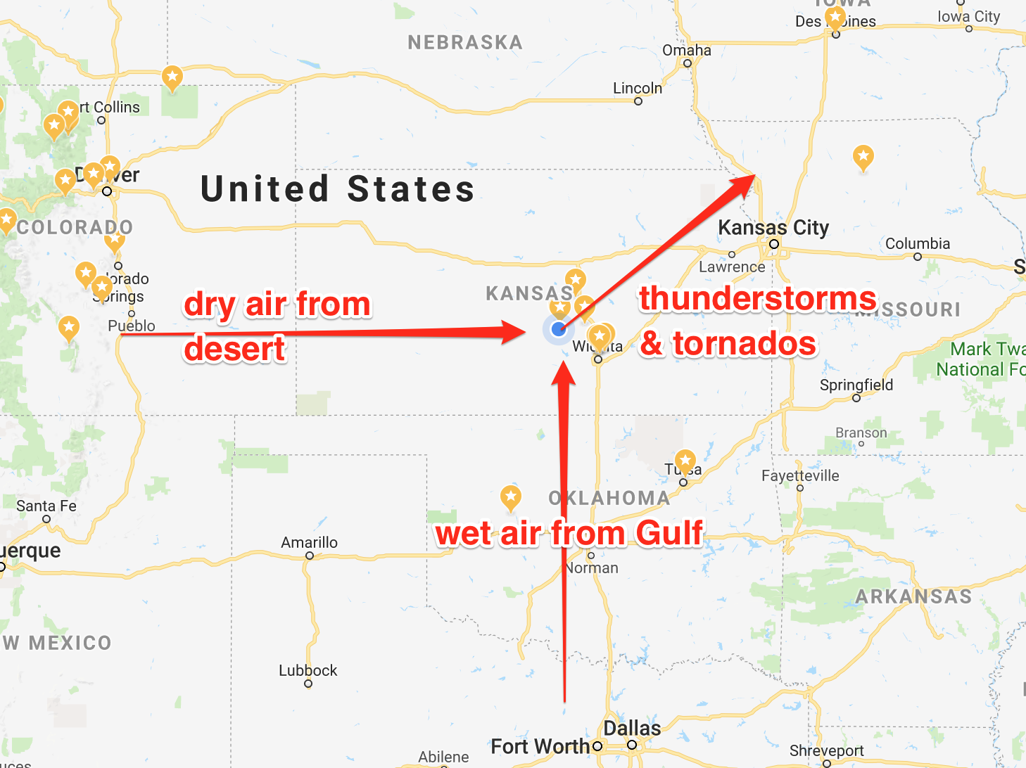
The tail end storm is usually the SW-most storm in the line of storms that stretches from SW to NE. The line of storms usually moves from SW to NE because when the north-moving wet air from the Gulf of Mexico hits east-moving dry air from the desert, it causes the shear that produces rotation for thunderstorms and tornados and the resulting storms move in the average of the two directions: NE. My cousin who is an amateur meteorologist would likely cringe at my simplistic description, but it does mostly describe reality. And let's be honest, all I care about are pretty pictures and not dying in the process. My needs are rather basic.

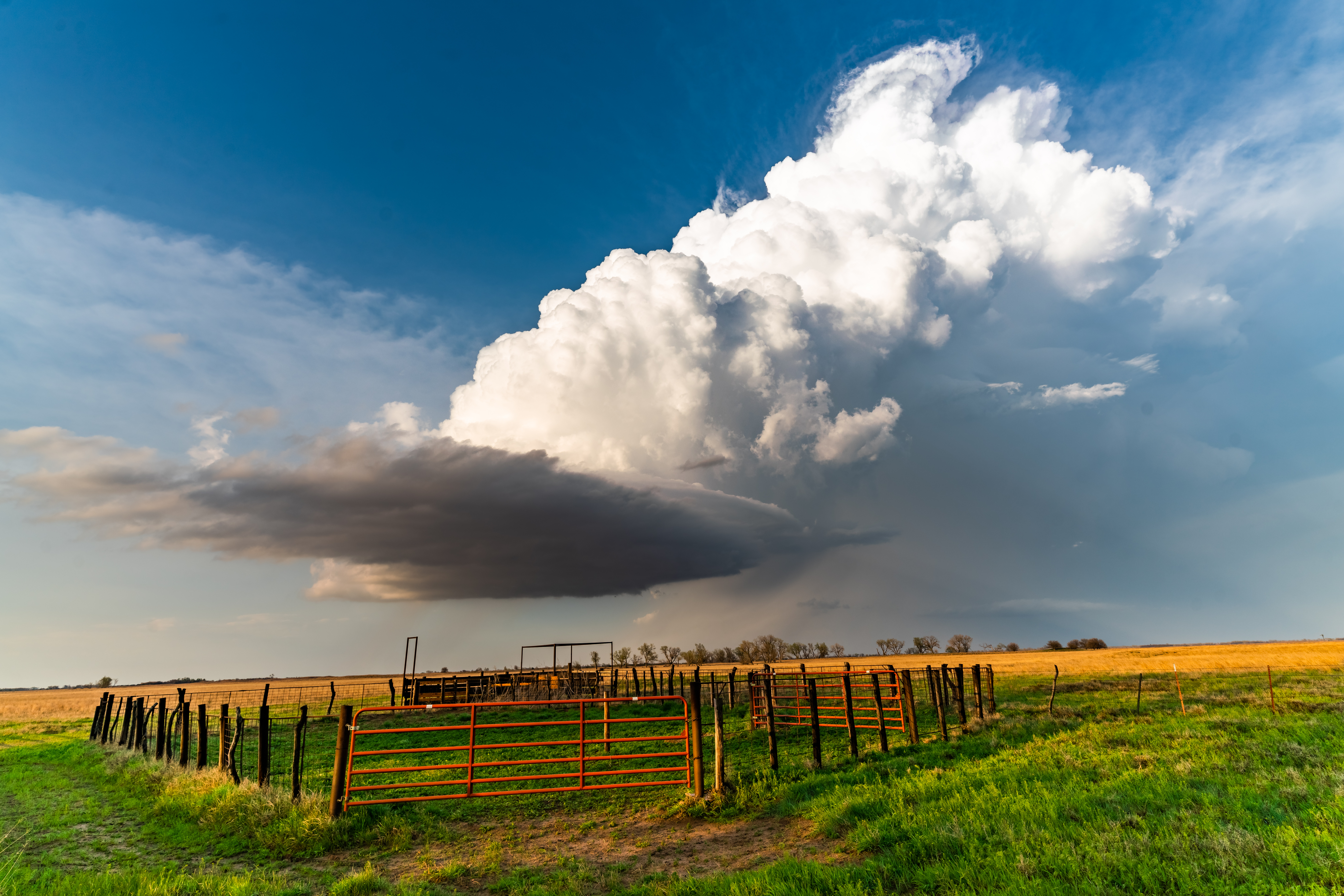
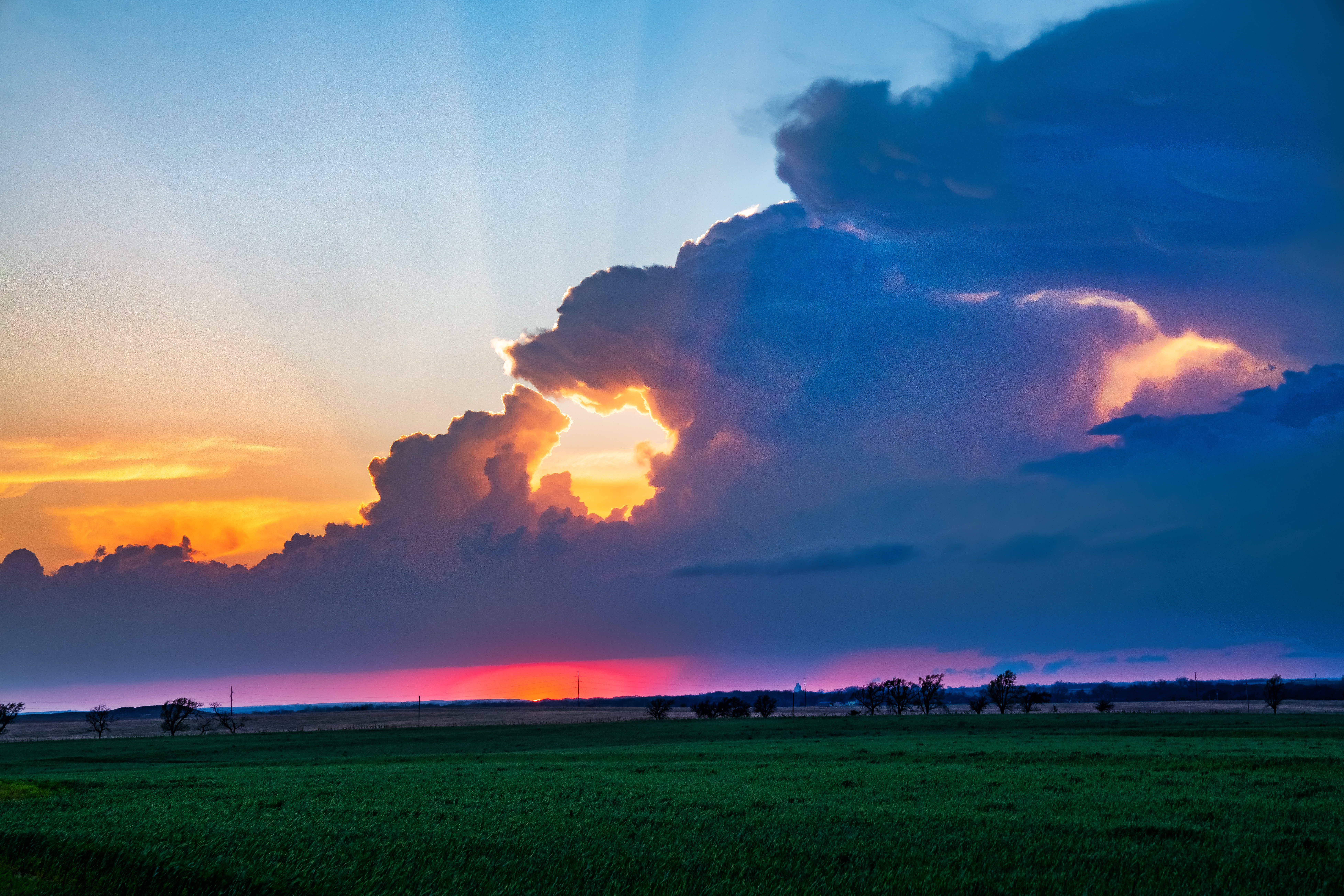
As the storm we were on eventually petered out, we raced north to catch a second line of storms that was mostly moving east along I-70. That second line of storms produced this tornado which we knew there was no way we could catch up to, but we raced north anyway to catch the tail end storm for sunset. It didn't disappoint:
The reason we like the tail-end storms (all else being equal) is two-fold:
- There are fewer other storms to mess up strong, orderly inflow that feeds the storm.
- There is often a clean break to clear air to the west (and sometimes south) of the storm, which gives it really nice definition. This also allows the storm structure to be lit from the west by the afternoon or setting sun.
We ended the evening beside a quiet pasture watching the line of storms to the north, filled with lots of lightning, pass slowly before us from west to east. I set up a quick time-lapse, though I wish I would have had more time as it was a great setup:
(I'd love to use d.tube instead, but it keeps giving me error messages! First it tells me I haven't uploaded a Snap, then when I upload the Snap, it says I've not uploaded the video.)
If you want a more mesmerizing version of the time-lapse on loop, check out this (albeit lower-res) GIF. If you want some storm time lapses that are 100x better than this, check out Mike Olbinski's Emmy-winning work.
Do you love or hate storms? What's your favorite storm photo or time-lapse of all time?
They look amaaaazing! Wow! Great work!
Thanks!
Congratulations and a very warm welcome to Steemit! Your image was just posted as a winning one for the daily 7 World's Continent Photo Challenge. See if you can attend the post and answer some of the congratulation comments for your increased engagement. Thank you and have a great day. Tomas
7 World’s Continents Photo Challenge – African Wednesday week #33 – winner announcement!
You got a couple of great photos there. You ever had any close calls out there chasing storms?
Thanks!
May 2nd, the day after the above story, was another high probability day in my home area. I went out by myself this time. I was a little late, sadly, and missed a GORGEOUS wall cloud which my cousin snapped. Here's his low-quality cell phone snap: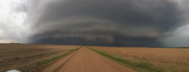
So I was out wandering around, out of sorts and out of position. I decided to try to sneak to the east of the line of storms to get free of the mist and sprinkles that were obscuring my views. The most direct route just clipped the edge of the core. In storm chasing terms, going through the core is called "core punching" and is frowned upon unless there's good reason. Often the storm core contains high winds and hail and that's also the highest probability area for a tornado to set down. This storm was not tornado warned, so there was little danger of that. However, it was a huge hail storm; see this photo taken by my neighbor of the hail from that storm: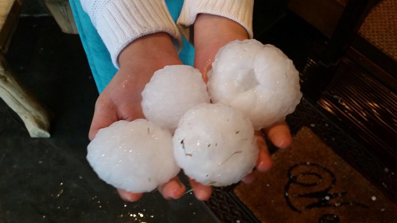
I saw on radar that I was going to pass through the very edge of the storm's core going the most direct route east (to go east I had to first go north to Hwy. 50), but going east any other way would have had me going a long way around and would have put me further south than I wanted. So I went north into the edge of the storm core. In the ten minutes it took to go north, the storm had moved considerably east, so I was in the middle of the storm core rather than the edge. I could not see more than a few feet it was raining so hard. I got a little hail, but not much. The primary hazards were the sheets of rain and the strong winds. Then I got stuck behind a semi going east (and it was not even close to safe to pass) which kept me moving with the storm (and only slowly gaining on it) right in its core with the additional spray of the truck in front of me.
I finally got ahead of the storm and had some enjoyable experiences out of the storm core, though it wasn't very photogenic. However, now the storm core was between myself and home. I was happy that I would be moving against the storm this time and my core punch would take far less time. I drove back west through the storm core and as I drove along, an absolutely enormous gust of wind came along and I may have been hydroplaning to boot (I'm not 100% sure), but I had to turn my wheel at a 75 degree angle to the right to keep from getting pushed over yellow line into oncoming traffic. Even with my wheel turned at that angle, I was slowly and inexorably sliding toward the center of the road. Suddenly I was through the gust of wind and I jerked the wheel back to 10 degrees to the right in order to not swerve into the ditch.
I know that's quite mild compared to what most storm chasers have experienced, but it scared me enough I pulled off and waited for the storm to finish passing me with me stationary.
Sounds pretty intense to me.
We don't get weather like that very often here. Too many mountains. But we do occasionally get micro-bursts which can be kinda scary. Last year half the city had no power for a week due to one. Those are fairly rare though. Or at least our state (Montana) is big enough that most the places they probably happen are more or less uninhabited.
That is some monster hail there. Hate to get smacked in the noggin' by one of those.
Great post @hansmast! Love the map and descriptions.
Thanks, man! I always love figuring out how stuff works.
Congratulations @hansmast! You have completed some achievement on Steemit and have been rewarded with new badge(s) :
Click on any badge to view your own Board of Honor on SteemitBoard.
To support your work, I also upvoted your post!
For more information about SteemitBoard, click here
If you no longer want to receive notifications, reply to this comment with the word
STOP