Hiking in Liguria: Cima delle Saline and Cima Pian Ballaur.
From Carnino Inferiore (1387), take the mule track that climbs through hairpin bends in the woods.
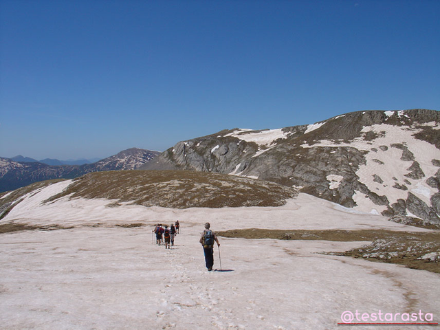
After emerging on a dirt road you reach the locality of Tetti delle Donzelle (1537) at the foot of the bastion of the Rocce del Manco .
From here the path goes up the left orographic side of the valley and enters the narrow Gola delle Saline. After crossing the stream, on the opposite side, a grassy slope is remounted until it comes out on the pasture of the Gias delle Saline (2000).
Continuing in the center of the Da Carnino Inferiore (1387), take the mule track which climbs through hairpin bends in the woods.
From here the path goes up the left orographic side of the valley and enters the narrow Gola delle Saline. After crossing the stream, on the opposite side, a grassy slope is remounted until it comes out on the pasture of the Gias delle Saline (2000).
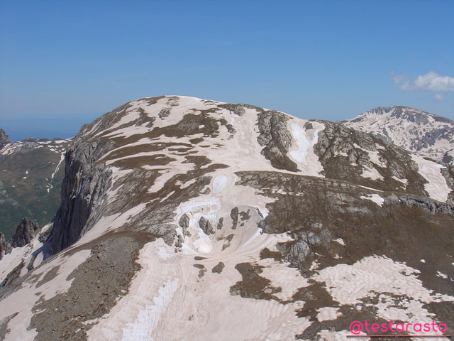
Continuing in the center of the valley, you reach Passo delle Saline (2174). From the pass, a track climbs the entire eastern ridge of the mountain until it reaches the summit of the Cima delle Saline (2612).
From the Cima delle Saline you descend on grassland in a south-west direction until you reach the wide depression that stretches between the Saline and the Ballaur. From here, through vague traces and some red notches, you go up to Cima Pian Ballaur (2604).
Warning: in this section, in case of fog, there may be major orientation difficulties.
From the summit you can travel along the wide western ridge, quickly reaching Colle del Pas (2342). At the hill, turn left and descend into the Conca di Piaggia Bella, under which one of the largest karst systems in Italy develops. After having touched the Saracco-Volante Hut (2220) the path continues gently on the bottom of the basin to the Passo delle Mastrelle (2023) beyond which it plunges into the Vallone di Carnino .
From the pass, the path descends with a steep serpentine until, at an altitude of 1700 meters, it meets the itinerary coming from the Don Barbera Refuge which soon leads to Carnino Superiore (1397). Finally, following the asphalt or the mule track that branches off to the left after the parking, you return to Carnino Inferiore.

CARNINO INFERIORE (1387) - CIMA DELLE SALINE (2612) - CIMA PIAN BALLAUR (2604)
Ascent time: 3 hours to the Cima delle Saline + 1 hour to the Cima Pian Ballaur
Total time: 6.30 am
After emerging on a dirt road you reach the locality of Tetti delle Donzelle (1537) at the foot of the bastion of the Rocce del Manco . From here the path goes up the left orographic side of the valley and enters the narrow Gola delle Saline. After crossing the stream, on the opposite side, a grassy slope is remounted until it comes out on the pasture of the Gias delle Saline (2000).
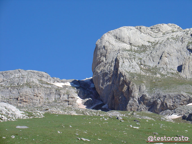
Here you will find a signpost: turn left and go up the steep grassy slopes to the foot of the imposing rock wall (some faded red triangles lead a little further to the left; instead, take the very obvious entrance as a reference) canal that runs under the large wall). You go up the canal very carefully: you can walk it on the rocks (degree of difficulty F, with ice you need an ice ax and crampons) or, slightly more to the left, on mixed terrain of rocks and grass (EE, some red marks).
Then you come out on the south-eastern edge of the Saline-Ballaur plateau and continue on the right, along the ridge, towards the summit of the Saline (2612), now near.
Warning: in the last stretch, in case of fog, there may be major orientation difficulties.
On the way back, follow the track that descends along the eastern ridge of the mountain to Passo delle Saline (2174).
Then turn right and follow the excellent path that leads shortly to the Gias delle Saline beyond which you reconnect with the ascent route.
CARNINO INFERIORE (1387) - CIMA DELLE SALINE (2612) for the southeast canal
Ascent time: 3 hours
Total time: 5.15 hours
This chain is well delimited to the south by the deep furrow of the Tanaro Valley which in Garessio bends towards the west to the Brigas of Carnino and Upega hamlets.
To the north, however, five parallel and perpendicular ridges slope down towards the plain, branching off into as many ridges separated from each other by the Monregalese valleys: Mongia Valley, Casotto Valley, Roburentello Valley, Val Corsaglia, Val Maudagna , Ellero Valley, Lurisia Valley and Valle Pesio.
The southern sides of this chain of the Alps face Liguria and the Val Tanaro is close to our region in terms of culture and history, so much so that the dialects that are still spoken in Liguria are Ligurian.
Cima Bertrand and Cima Missun are located south of Marguareis on the branch of the Alpine chain that runs towards Ventimiglia and which enters Ligurian territory on the summit of Saccarello.
The Rocca dell'Abisso , the first peak of the Maritime Alps, guards the Valle Roia . This beautiful valley, long disputed by the Savoy and the Republic of Genoa, was assigned to the Kingdom of Sardinia in 1815 and incorporated into the County of Nice.
Typically Ligurian are the towns of Brig and Tenda and Italian the surnames of the people who live there. The ridge route from Colle di Tenda to Rocca dell'Abisso follows the true ethnic and geographical boundary of our region.
The mountains of the Tuscan-Emilian Apennines between the Cirone Pass and the orographic knot of Cima Belfiore (on which the Magra, Secchia and Serchio basins converge) are easily accessible from La Spezia and for history and culture they are also close to our region.
The southeast channel of the Saline, still in the shade, dominated by the imposing and "dolomitic" rock face.
Sources.
.png)