Prepper Navigation & My Traffic Light System!


Travelling from one location to another quickly and efficiently can be easy if you are on a well selected/planned route and under good conditions. However! In times of stress and under austere conditions, you may be operating under constraints, the weather or visibility may be limited and time can be of the essence, putting yourself under pressure. These factors may lead to mistakes and before you know it.....You are either LOST or time has passed for far to long.
Getting lost may not just be a huge navigational error, but may also involve a series of small errors over a long distance/time.
Errors may be caused by a multitude of factors, from Compass, map interpretation to pacing errors or just plain rushing.
There are many aids to navigation, including:
Map | Compass | Route Card | Pacing Beads | GPS

In order to move quickly, accurately and efficiently, I adopt a system of movement that enables a common thinking pattern that allows me to get into a routine.
My routine involves:
Looking at the terrain as a whole, both map and visual, then I build a mental picture of the 'lie of the land' and the route towards my Objective, Target or Goal.
I would break the route down into manageable Legs/segments based on terrain, rest stops and resources. These legs would be based around a bearing and KEY points that are visually identifyable from as far as possible.
This counters stopping too often for confirmatory navigational checks, which adds transit time.
Examples of Key Points are distinctive manmade or natural landmarks and can include:
The list can be extensive, but so long as they are distinctive, that is the key, I will also use:
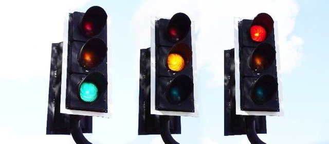
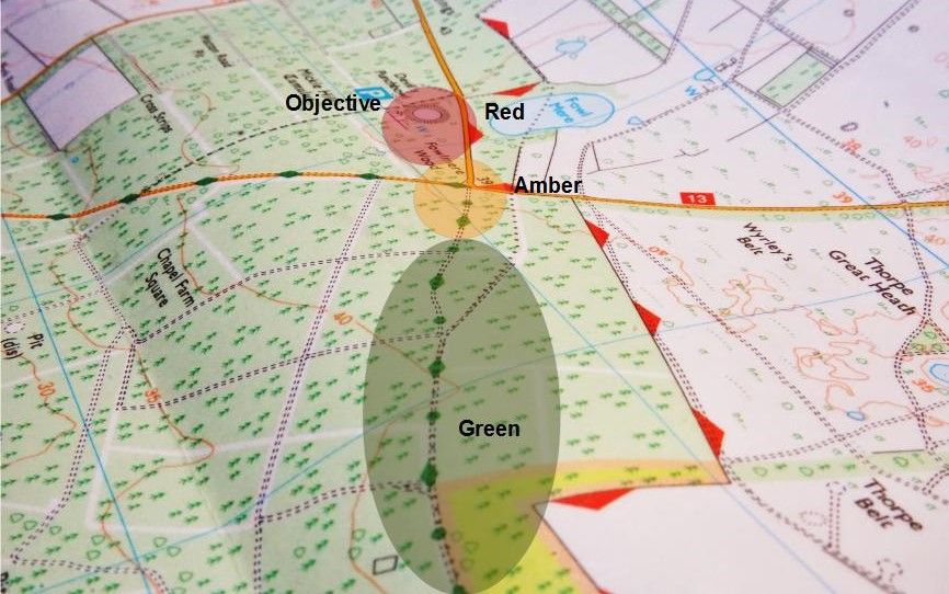
After these have been established, I orientate then move... This is prime time to implement the GREEN-AMBER-RED traffic-light system.

GREEN – I have identified my distinct KEY POINT & BEARING and know which direction to set off – I move as fast as possible with minimal to no navigational checks involved, just quick glances at my compass or map.
AMBER – I have covered over 2/3rds of my navigational LEG and am approaching my destination – At this point I slow my pace, taking in all navigaitonal indicators in my surroundings. Compass checks become more frequent, my pulse-rate slows and thought clarity increases. At this stage OVERSHOOTING my target is in the forefront of my mind.
RED – I am within the last few hundred metres of my objective. I slow my pace down to a walk – Map checks are very frequent, ensuring maximum accuracy. As my pace has slowed, i am sufficiently relaxed, my breathing and brain are coherent and I know exactly where the end of this navigaitonal leg is. I then start to orientate myself again for the next leg and prepare to GO GREEN at the end of this leg!.....
Mental confusion may result when you are panting and your pulse is racing whilst navigating / visually translating map details into movement.

At ANY stage, I may change from one colour alert stage to another -eg- Green to RED and back to GREEN or AMBER in order to overcome difficult, unexpected terrain or unfamiliar areas that have not been identified previously...

I am sure that many people may already subconsciously adopt this method of navigation, this is one system I have used with confidence and will continue to use.
I have found through countless navigational exercises that the biggest errors are most likely to occur within the first stages of my route. Once moving, I adjust and orientation becomes easier.
Beep! Beep! @shadow3scalpel at your service. I am here to assist all military members on Steemit. This HumVee will be scouting posts from a list of Veterans that is maintained by @chairborne. If you are a Veteran and new to Steemit, and you have questions or want to join the Veterans community, reply to this comment. We got your six, unless you are in the rear with the gear. Ooh-Rah!
Comment by @inthenow. This is a opt-in bot.
Thanks man, appreciate it.
Some of the techniques you describe remind me of my Duke Of Edinburgh Award days walking across Dartmoor, looking for key points on the map and splitting the walk into sections and then trying to work out how long it should take to walk each section.
That was about 25 years ago and I have all but forgotten now how to navigate with a map and compass.
One question I have is, do compasses lose accuracy over time? I found an old Silva compass the other day and I think it might even have been the one I used all those years ago, the same question goes for old OS maps.
Your DofE techniques probably revolve around the initial planning of a Route Card (depicted above).
As for Compasses:
Modern Maps will never lose their accuracy. Depending on where in the world you are will depend on the maps accuracy, as some countries base their mapping on ariel photographs. Personally i think the Ordnance Survey Maps of Great Britain are the best in the world... They are regularly updated and continually assessed for accuracy. Newer editions are produced according to new roads, tracks and buildings etc
Hope i answered your question.
Steemit is not letting me upvote your post, I've tried like 10 times! 😒
You have a great strategy there, thanks for sharing! :)
Just about didn't want me to comment either.. lol it's a tad slow this morning.
No problem, hope you enjoyed it and it got you thinkin...
I have a terrible "compass sense" of direction--I navigate solely by landmarks, which drives my more compass-savvy Husband crazy. But I guess your system could be adapted for landmark navigation :))) Very interesting and informative post! I like how you have all the distances and times mapped out to each key point. It makes perfect sense as a way to quickly catch yourself if you start overshooting the mark.
Yeah, that's pretty much a standard ROUTE-CARD which is a good solid go-to piece of info. There's nothing wrong with Landmark navigation at all, so long as you don't take your eye off the ball or loose sight of the landmark... Compasses are just aids, the same as all other navigational devices and can still go wrong or be mis-used...
So long as you've got a good selection of skills and tools to get you where you wanna be - Then its good.
Congratulations! This post has been upvoted from the communal account, @minnowsupport, by Prepper Veteran UK from the Minnow Support Project. It's a witness project run by aggroed, ausbitbank, teamsteem, theprophet0, someguy123, neoxian, followbtcnews, and netuoso. The goal is to help Steemit grow by supporting Minnows. Please find us at the Peace, Abundance, and Liberty Network (PALnet) Discord Channel. It's a completely public and open space to all members of the Steemit community who voluntarily choose to be there.
If you would like to delegate to the Minnow Support Project you can do so by clicking on the following links: 50SP, 100SP, 250SP, 500SP, 1000SP, 5000SP.
Be sure to leave at least 50SP undelegated on your account.
We loved your great content so much we wanted to showcase it in our weekly curation report where you will be paid from the post payout. Thank you!
You can find the post here
https://steemit.com/helpie/@helpie/helpie-s-homesteading-curation-report-10-by-helpie-curator-llfarms
Yeah no worries - Thanks man.
This is some crazy skill to have... we recently bought a sextant ourselves and I will attempt to learn how to use it properly. This however is a little above my level of confidence currently!
ha!
This technique can be quite easily honed with some Orienteering practice - Even making a course by yourself can be easily done... The confidence that comes out of this can develop very quickly.