MapLite for the future of autonomous cars?
The recent fatal accident with the Ubera autonomous car shows that the autonomous vehicle technology is not yet ready for mass deployment. One reason for this is that there are not many roads on which to drive such cars. They are tested primarily in cities, and before their owners set off on the road, such as Google, they devote huge resources to creating 3D maps with precisely marked positions of lines separating traffic lanes, traffic lights and kerbstones. Autonomous cars cannot cope without such detailed maps. However, most roads around the world are not so well described, horizontal signs are poorly visible, roads are not well lit. In the near future, it is unlikely that maps will be developed to allow autonomous cars to use these roads.
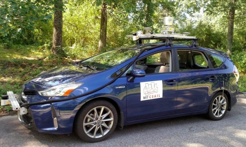
One way of dealing with this problem is to build a system advanced enough that an autonomous car using it does not need a previously prepared map. Researchers from the MIT Computer Science and Artificial Intelligence Laboratory (CSAIL) have just taken an important first step towards the development of such a system. They created MapLite, a technology that combines GPS data with Google Maps data and, using a full set of sensors, is able to travel on roads without a specially prepared 3D map. Toyota Prius was equipped with an LIDAR system, additional sensors and a MapLite as part of the tests carried out in cooperation with Toyota. It turned out that the vehicle was performing well on unpaved rural roads in Devens, Massachusetts, and was able to detect the road more than 30 metres in front of it.
Nobody has tried such an approach before, because it is much more difficult in this case to achieve accuracy and reliability as with the previously described maps. Our system works on board the car and is able to drive it beyond the few roads currently being tested by the developers of autonomous vehicles, says Teddy Ort of CSAIL.
The systems currently used in stand-alone cars are based almost entirely on maps. The vehicle must be equipped with a detailed 3D map of the road on which it is driving. All sensors, such as LIDAR or image recognition algorithms, are not used to navigate but only to avoid other moving objects, such as pedestrians or cars.
MapLite works differently. It uses sensors to navigate, and GPS data is used to determine the position of the vehicle. The system first determines its destination. While driving, it uses a "local navigation destination" which must be within the reach of the vehicle's sensors. Then, algorithms determine the route to take to reach the "local navigation destination", and sensors like LIDAR use it to find the road edge. When assessing what a road is and what it is not, MapLite assumes that it will be flatter than its surroundings. MapLite has developed a system of models that describe a number of similar situations. These types of models tell the vehicle how to behave at a crossroads or how to drive on specific types of roads. MapLite is a learner in specific road types, and when he learns one road type, he moves on to the next.
"MapLite still has many limitations. For example, it is not suitable for use on mountain roads, as the current version does not take into account major changes in height. In the near future, scientists want to expand the range of ways MapLite manages. I imagine that in the future, autonomous cars will use some kind of 3D map in cities. But if their owner wants to drive on a dirt road, such a vehicle should do as well as a man. We hope that our work is a step in this direction," says Ort.
Congrats!
We saw something we like here so, we decided to Upvote and resteem.
How do we select posts for resteem? Click Manual to find out.
We are here cos' you follow us, if you don't, follow now @alphawhale