Design of a Horizontal Well
Good afternoon, Steemians, today I want to share a little engineering with you, the oil world is a beautiful activity that requires a lot of discipline and studies, in Venezuela we have the largest reserve of heavy and extra heavy oil that exists in the world. However, we have many methods of drilling and draining the crude, comments on the horizontal wells we drill in the Orinoco Oil Belt, a directional well with a continuous section of the hole and another one on the left at 86 °, is the most design of common use, since they have a greater drainage capacity, then I mention the necessary data to plan one of these:
• Surface coordinates (North and East) of the Location to be drilled.
• Coordinates of the Entry Point (North and East) and its vertical depth with reference to sea level (TVDss) of the target arena.
• Coordinates of the Horizontal Point (North and East) with its (TVDss) where the best properties of the sand for navigation are found.
• Final coordinates (North and East) with your (TVDss) to where the drilling will be reached.
• Ground Elevation.
• Kelly Rotary Bushing.
This information is provided by a multidisciplinary team of (geologists, specialists in seismic, dynamic and static models, among others) according to the analysis carried out on the rock to be drained.
The design can be done manually (where you have to put enough numbers and calculations) or in some application (This tutorial is a basic as designing a well in a tool called Compass which belongs to a service company).
The horizontal well in the Orinoco Oil Belt consists of three phases of drilling.
Surface Hole: This phase depends on the depth of the aquifers in the area, is drilled with a packed string, water-based mud to prevent contamination and is coated to protect the area.
Intermediate Hole: It is drilled with a directional tool until the top of the target sand, with polymeric mud to prevent the clays from swelling, as well as the area is coated.
Producer Hole: It is drilled with a directional tool from the sand inlet to the final depth of the well according to the planning, the slotted liner is lowered for drainage.
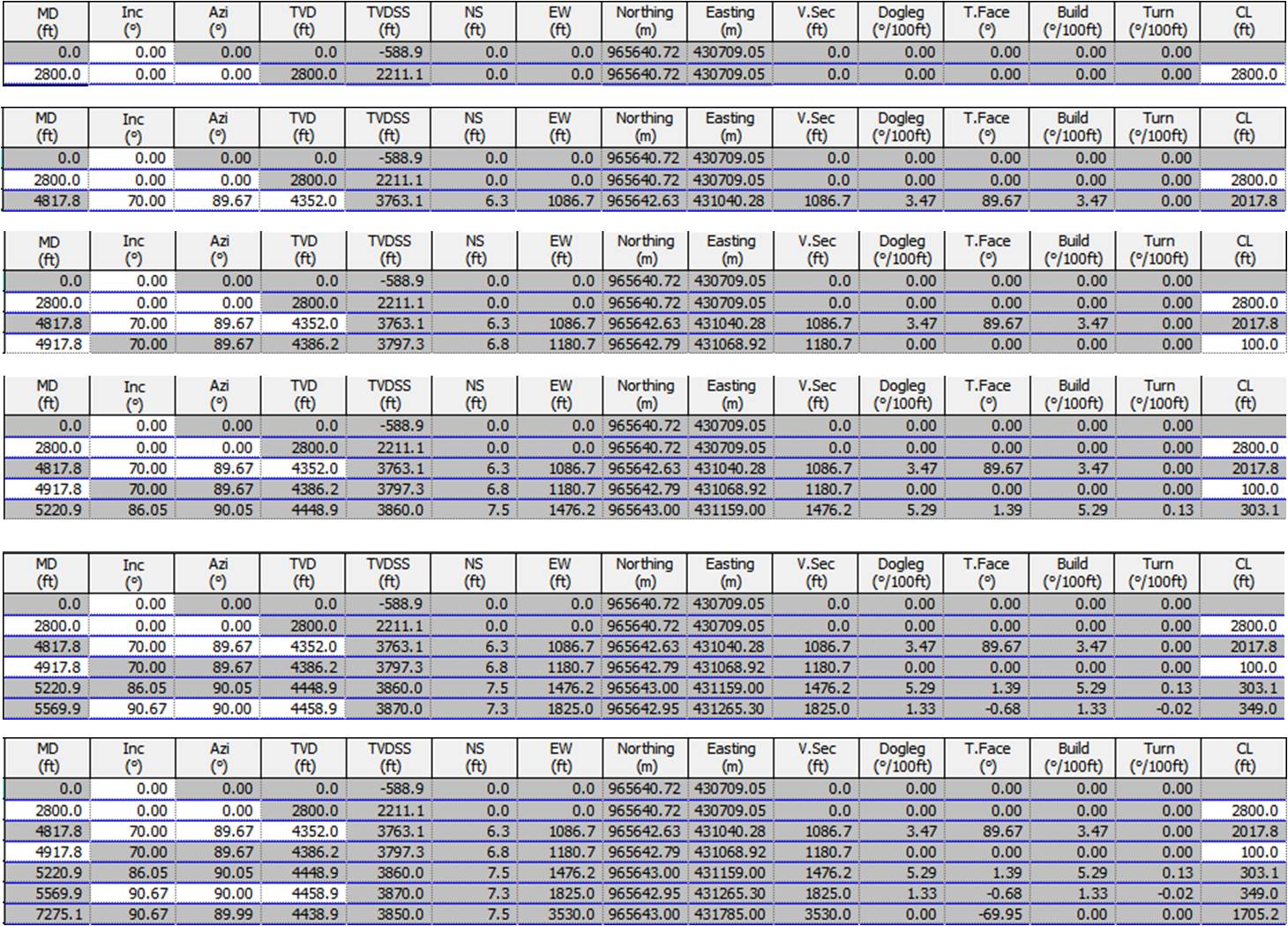
Basic Steps for planning a Horizontal Well:
1. Start Point. It is where the vertical part of the well ends and the deviation begins, this has to be greater than 100ft after the footing (final depth of the surface hole) to guarantee the exit of the directional tool in the second phase, this depends on how shallow or deep is the deposit, it is calculated with the measured depth (MD) that is the distance along the trajectory of the well from surface to any point of the hole, with Inclination in 0 ° and Direction in 0 °.
2. Start of the tangent. It is defined by three parameters Inclination that is the angle measured in degrees, between the vertical line and the tangent of the well in a station, can vary from 50 ° @ 80 ° depends on the area, Direction that is given according to the quadrant where It will perforate the well, it is the angle measured in degrees with reference of true north, magnetic north or north of grid and TVD that is the distance measured vertically from surface to any point located at the bottom of the hole, for this point it should be < 300ft of the TVD from the entry point to guarantee that the pump is submerged during the completion of the well.
3. End of the Tangent. It is maintained tangential 100ft in depth measured (MD) from the beginning to the end of it.
4. Entry point. Basically it is to point to the coordinates that were supplied, at this point we will be in the face of the sand so it is necessary to reach the requested TVD, an Incline of 83 ° @ 87 ° as the case may be, or if it is not calculated with the DogLeg not greater than 6 ° / 100ft is a measure of the total angular change in the hole, between two adjacent stations, is calculated using inclination and direction.
5. Horizontal Point It is to reach the maximum point of inclination of the deposit according to its dip usually varies between 88 ° @ 91 °, DogLeg <3 ° / 100ft to avoid fatigue in the liner, TVD requested.
6. Final point. The Tilt and Direction is aligned with the horizontal point, and the requested TVD is pointed.
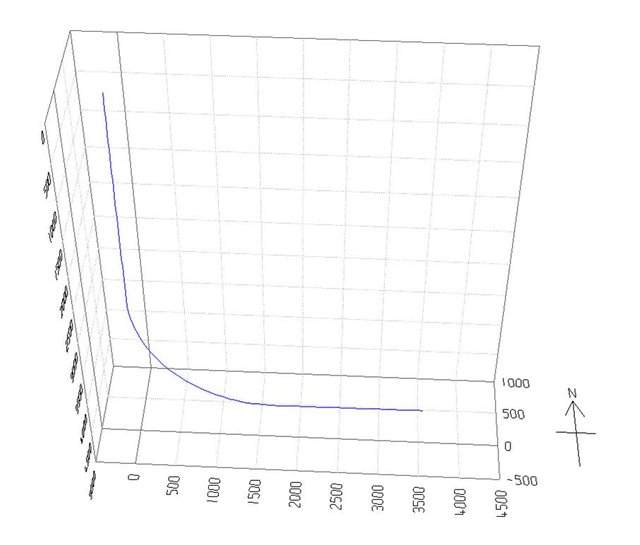
I show you the final result in a 3D view:
If you have any questions, you can leave me your comment, thanks for the visit.