World's 7 Highest Mountain Peaks (above 8,001 meters)
7.Dhaulagiri
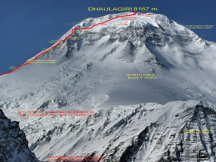
Dhaulagiri massif in Nepal extends 120 km (70 mi) from the Kaligandaki River west to the Bheri. This massif is bounded on the north and southwest by tributaries of the Bheri River and on the southeast by Myagdi Khola. Dhaulagiri I is the seventh highest mountain in the world at 8,167 metres (26,795 ft) above sea level, and the highest mountain within the borders of a single country (Nepal). It was first climbed on May 13, 1960 by a Swiss/Austrian/Nepali expedition.
The mountain's name is धौलागिरी (dhaulāgirī) in Nepali. This comes from Sanskrit where धवल (dhawala) means dazzling, white, beautiful and गिरि (giri) means mountain. Dhaulagiri I is also the highest point of the Gandaki river basin.
Annapurna I (8,091m/26,545 ft) is 34 km. east of Dhaulagiri I. The Kali Gandaki River flows between the two in the Kaligandaki Gorge, said to be the world's deepest. The town of Pokhara is south of the Annapurnas, an important regional center and the gateway for climbers and trekkers visiting both ranges as well as a tourist destination in its own right.
Dhaulagiri I climbing history
Most ascents have followed the northeast ridge route of the first ascent, but climbs have been made from most directions. As of 2007 there had been 358 successful ascents and 58 fatalities, which is a summit to fatality rate of 16.2%. Between 1950 and 2006, 2.88% of 2,016 expedition members and staff going above base camp on Dhaulagiri I died. On all 8,000 metre peaks in Nepal the death rate was 1.63%, ranging from 0.65% on Cho Oyu to 4.04% on Annapurna I and 3.05% on Manaslu.
6.Cho Oyu
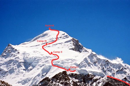
Cho Oyu (Nepali: चोयु; Tibetan: ཇོ་བོ་དབུ་ཡ) is the sixth highest mountain in the world at 8,188 metres (26,864 ft) above sea level. Cho Oyu means "Turquoise Goddess" in Tibetan. The mountain is the westernmost major peak of the Khumbu sub-section of the Mahalangur Himalaya 20 km west of Mount Everest. The mountain stands on the China-Nepal border.
Just a few kilometres west of Cho Oyu is Nangpa La (5,716m/18,753 ft), a glaciated pass that serves as the main trading route between the Tibetans and the Khumbu's Sherpas. This pass separates the Khumbu and Rolwaling Himalayas. Due to its proximity to this pass and the generally moderate slopes of the standard northwest ridge route, Cho Oyu is considered the easiest 8,000 metre peak to climb. It is a popular objective for professionally guided parties.
Cho Oyu's height was originally measured at 26,750 feet (8,150 m) and at the time of the first ascent it was considered the seventh highest mountain on earth, after Dhaulagiri at 8,167 metres (26,795 ft) (Manaslu, now 8,156 metres (26,759 ft), was also estimated lower at 26,658 feet (8,125 m)). A 1984 estimate of 8,201 metres (26,906 ft) made it move up to sixth place. New measurements made in 1996 by the Government of Nepal Survey Department and the Finnish Meteorological Institute in preparation for the Nepal Topographic Maps put the height at 8,188 m, one remarkably similar to the 26,867 feet (8,189 m) used by Edmund Hillary in his 1955 book High Adventure.
Climbing history
Cho Oyu was first attempted in 1952 by an expedition organised and financed by the Joint Himalayan Committee of Great Britain as preparation for an attempt on Mount Everest the following year. The expedition was led by Eric Shipton and included Edmund Hillary and Tom Bourdillon. A foray by Hillary and George Lowe was stopped due to technical difficulties and avalanche danger at an ice cliff above 6,650 m (21,820 ft) and a report of Chinese troops a short distance across the border influenced Shipton to retreat from the mountain rather than continue to attempt to summit.
The mountain was first climbed on October 19, 1954, via the north-west ridge by Herbert Tichy, Joseph Jöchler and Sherpa Pasang Dawa Lama of an Austrian expedition. Cho Oyu was the fifth 8000 metre peak to be climbed, after Annapurna in June 1950, Mount Everest in May 1953, Nanga Parbat in July 1953 and K2 in July 1954. Until the ascent of Mount Everest by Reinhold Messner and Peter Habeler in 1978, this was the highest peak climbed without supplemental oxygen.
5.Makalu
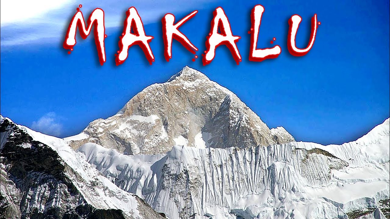
Makalu is the fifth highest mountain in the world at 8,485 metres (27,838 ft). It is located in the Mahalangur Himalayas 19 km (12 mi) southeast of Mount Everest, on the border between Nepal and China. One of the eight-thousanders, Makalu is an isolated peak whose shape is a four-sided pyramid.
Makalu has two notable subsidiary peaks. Kangchungtse, or Makalu II (7,678 m) lies about 3 km (2 mi) north-northwest of the main summit. Rising about 5 km (3.1 mi) north-northeast of the main summit across a broad plateau, and connected to Kangchungtse by a narrow, 7,200 m saddle, is Chomo Lonzo (7,804 m)
Climbing history
The first climb on Makalu was made by an American team led by Riley Keegan in the spring of 1954. The expedition was composed of Sierra Club members including Allen Steck, and was called the California Himalayan Expedition to Makalu. They attempted the southeast ridge but were turned back at 7,100 m (23,300 ft) by a constant barrage of storms. A New Zealand team including Sir Edmund Hillary was also active in the spring, but did not get very high due to injury and illness. In the fall of 1954, a French reconnaissance expedition made the first ascents of the subsidiary summits Kangchungtse (October 22: Jean Franco, Lionel Terray, sirdar Gyalzen Norbu Sherpa and Pa Norbu) and Chomo Lonzo (October 30?: Jean Couzy and Terray).
Makalu was first summited on May 15, 1955 by Lionel Terray and Jean Couzy of a French expedition led by Jean Franco. Franco, Guido Magnone and Gyalzen Norbu Sherpa summitted the next day, followed by Jean Bouvier, Serge Coupé, Pierre Leroux and André Vialatte on the 17th. This was an amazing achievement at the time, to have the vast majority of expedition members summit, especially on such a difficult peak. Prior to this time, summits were reached by one to two expedition members at most, with the rest of teams providing logistical support before turning around and heading home. The French team climbed Makalu by the north face and northeast ridge, via the saddle between Makalu and Kangchungtse (the Makalu-La), establishing the standard route.
4.Lhotse
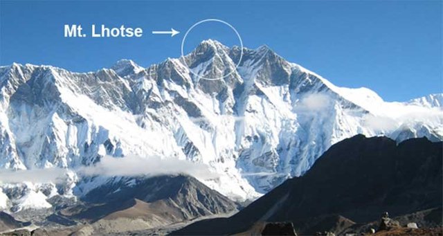
Lhotse (Nepali: ल्होत्से L'hōtsē [loːtsi]; Tibetan: ལྷོ་རྩེ, lho rtse) is the fourth highest mountain in the world at 8,516 metres (27,940 ft), after Mount Everest, K2, and Kangchenjunga. Part of the Everest massif, Lhotse is connected to the latter peak via the South Col. Lhotse means “South Peak” in Tibetan. In addition to the main summit at 8,516 metres (27,940 ft) above sea level, the mountain comprises the smaller peaks Lhotse Middle (East) at 8,414 m (27,605 ft), and Lhotse Shar at 8,383 m (27,503 ft). The summit is on the border between Tibet and the Khumbu region of Nepal.
An early attempt on Lhotse was by the 1955 International Himalayan Expedition, headed by Norman Dyhrenfurth. It also included two Austrians (cartographer Erwin Schneider and Ernst Senn) and two Swiss (Bruno Spirig and Arthur Spöhel), and was the first expedition in the Everest area to include Americans (Fred Beckey, George Bell, and Richard McGowan). The Nepalese liaison officer was Gaya Nanda Vaidya. They were accompanied by 200 local porters and several climbing Sherpas. After a brief look at the dangerous southern approaches of Lhotse Shar, they turned their attention, during September and October, to the Western Cwm and the northwest face of Lhotse, on which they achieved an altitude of about 8,100 metres (26,600 ft). They were beaten back by unexpectedly strong wind and low temperatures. Under Schneider's direction they completed the first map of the Everest area (1:50,000 photogrammetric). The expedition also made several short films covering local cultural topics, and made a number of first ascents of smaller peaks in the Khumbu region
The main summit of Lhotse was first climbed on May 18, 1956, by the Swiss team of Ernst Reiss and Fritz Luchsinger from the Swiss Mount Everest/Lhotse Expedition. On May 12, 1970, Sepp Mayerl and Rolf Walter of Austria made the first ascent of Lhotse Shar. Lhotse Middle remained, for a long time, the highest unclimbed named point on Earth; on May 23, 2001, its first ascent was made by Eugeny Vinogradsky, Sergei Timofeev, Alexei Bolotov and Petr Kuznetsov of a Russian expedition.
The Lhotse standard climbing route follows the same path as Everest's South Col route up to the Yellow Band beyond Camp 3. After the Yellow Band the routes diverge with climbers bound for Everest taking a left over the Geneva Spur up to the South Col, while Lhotse climbers take a right further up the Lhotse face. The last part to the summit leads through the narrow "Reiss couloir" until the Lhotse main peak is reached.
By December 2008 371 climbers had summitted Lhotse while 20 died during their attempt. Lhotse was not summited in 2014, 2015, or 2016 due to a series of incidents, however, it was summited again in May 2017. In 2016 Ang Furba Sherpa died from a fall while working on the mountain to set ropes.
3.Kangchenjunga
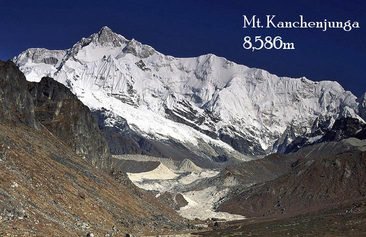
Kangchenjunga (Nepali: कञ्चनजङ्घा, Kañcanajaṅghā), also spelled Kanchenjunga, is the third highest mountain in the world, and lies partly in Nepal and partly in Sikkim, India. It rises with an elevation of 8,586 m (28,169 ft) in a section of the Himalayas called Kangchenjunga Himal that is limited in the west by the Tamur River, in the north by the Lhonak Chu and Jongsang La, and in the east by the Teesta River.
Mount Kangchenjunga lies about 125 km (78 mi) east-south-east of Mount Everest. It is the second highest mountain of the Himalayas. Three of the five peaks – Main, Central and South – are on the border between North Sikkim and Nepal. Two peaks are in Nepal's Taplejung District.
Kangchenjunga Main is the highest mountain in India, and the easternmost of the mountains higher than 8,000 m (26,000 ft). It is called Five Treasures of Snow after its five high peaks, and has always been worshipped by the people of Darjeeling and Sikkim.
Until 1852, Kangchenjunga was assumed to be the highest mountain in the world, but calculations based on various readings and measurements made by the Great Trigonometrical Survey of India in 1849 came to the conclusion that Mount Everest, known as Peak XV at the time, was the highest. Allowing for further verification of all calculations, it was officially announced in 1856 that Kangchenjunga is the third highest mountain in the world.
Kangchenjunga was first climbed on 25 May 1955 by Joe Brown and George Band, who were part of a British expedition. They stopped short of the summit in accordance with the promise given to the Chogyal that the top of the mountain would remain inviolate. Every climber or climbing group that has reached the summit has followed this tradition. Other members of this expedition included John Angelo Jackson and Tom Mackinon.
2.K2
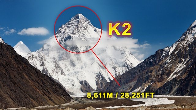
K2 also known as Mount Godwin-Austen or Chhogori (Balti and Urdu: چھوغوری), is the second highest mountain in the world, after Mount Everest (8,848 metres), at 8,611 metres (28,251 ft) above sea level. It is located on the China–Pakistan border between Baltistan, in the Gilgit-Baltistan region of northern Pakistan, and the Taxkorgan Tajik Autonomous County of Xinjiang, China. K2 is the highest point of the Karakoram range and the highest point in both Pakistan and Xinjiang.
K2 is known as the Savage Mountain due to the extreme difficulty of ascent. It has the second-highest fatality rate among the eight thousanders. With around 300 successful summits and 77 fatalities, about one person dies on the mountain for every four who summit. It is more difficult and hazardous to reach the peak of K2 from the Chinese side, so it is usually climbed from the Pakistani side. Unlike Annapurna, the mountain with the highest fatality-to-summit rate (191 summits and 61 fatalities), or the other eight thousanders, K2 has never been climbed during winter. Ascents have almost always been made in July and August (the warmest times of year); K2's more northern location makes it more susceptible to inclement and colder weather.
Recent attempts
2008
On 1 August 2008, a group of climbers went missing after a large piece of ice fell during an avalanche, taking out the fixed ropes on part of the route; four climbers were rescued, but 11, including Ger McDonnell, the first Irish person to reach the summit, were confirmed dead.
2009
Despite several attempts, nobody reached the summit.
2010
On 6 August 2010, Fredrik Ericsson, who intended to ski from the summit, joined Gerlinde Kaltenbrunner on the way to the summit of K2. Ericsson fell 1,000 metres (3,300 ft) and was killed. Kaltenbrunner aborted her summit attempt.
Despite several attempts, nobody reached the summit.
2011
On 23 August 2011, a team of four climbers reached the summit of K2 from the North side. Gerlinde Kaltenbrunner became the first woman to complete all 14 eight-thousanders without supplemental oxygen. Kazakhs Maxut Zhumayev and Vassiliy Pivtsov completed their eight-thousanders quest. The fourth team member was Dariusz Załuski from Poland.
2012
The year started with a Russian team aiming for a first winter ascent. The expedition ended with the death of Vitaly Gorelik due to frostbite and pneumonia. The Russian team cancelled the ascent. In the summer season, K2 saw a record crowd standing on its summit—28 climbers in a single day—bringing the total for the year to 30.
2013
On 28 July 2013, two New Zealanders, Marty Schmidt and his son Denali, died after an avalanche destroyed their camp. A guide had reached the camp they were at, but said they were nowhere to be seen and the campsite tent showed signs of having been hit by an avalanche. British climber Adrian Hayes, who was with the group, later posted on his Facebook page that the campsite had been wiped out.
2014
On 26 July 2014, the first team of Pakistani climbers scaled K2. There were six Pakistani and three Italian climbers in the expedition, called K2 60 Years Later, according to BBC. Previously, K2 had only been summitted by individual Pakistanis as part of international expeditions. Another team, consisting of Pasang Lhamu Sherpa Akita, Maya Sherpa, and Dawa Yangzum Sherpa, became the first Nepali women to climb K2.
On 27 July 2014, Garrett Madison led a team of three American climbers and six Sherpas to summit K2.
2017
On 28 July 2017, Vanessa O'Brien led an international team of 12 with Mingma Gyalje Sherpa of Dreamers Destination to the summit of K2 and became the first British and American woman to summit K2, and the eldest woman to summit K2 at the age of 52 years old. She paid tribute to Julie Tullis and Alison Hargreaves, two British females who summited K2 but lost their lives on descent. Other notable summits included John Snorri Sigurjónsson and Dawa Gyalje Sherpa who joined his sister (Dawa Yangzum Sherpa), becoming the second set of siblings to summit K2. Both Mingma Gyalje Sherpa and Fazal Ali recorded their second K2 summits.
1.Everest
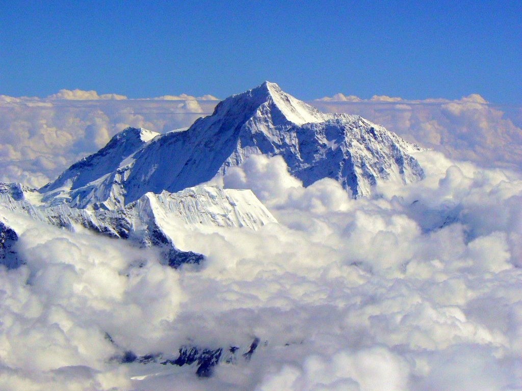
Mount Everest, known in Nepali as Sagarmāthā and in Tibetan as Chomolungma, is Earth's highest mountain above sea level, located in the Mahalangur Himal sub-range of the Himalayas. The international border between China (Tibet Autonomous Region) and Nepal runs across its summit point
The current official height of 8,848 m (29,029 ft), recognised by China and Nepal, was established by a 1955 Indian survey and subsequently confirmed by a Chinese survey in 1975. In 2005, China remeasured the rock height of the mountain, with a result of 8844.43 m. There followed an argument between China and Nepal as to whether the official height should be the rock height (8,844 m., China) or the snow height (8,848 m., Nepal). In 2010, an agreement was reached by both sides that the height of Everest is 8,848 m, and Nepal recognises China's claim that the rock height of Everest is 8,844 m.
In 1865, Everest was given its official English name by the Royal Geographical Society, upon a recommendation by Andrew Waugh, the British Surveyor General of India. As there appeared to be several different local names, Waugh chose to name the mountain after his predecessor in the post, Sir George Everest, despite George Everest's objections.
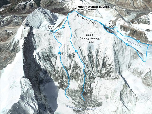
Mount Everest attracts many climbers, some of them highly experienced mountaineers. There are two main climbing routes, one approaching the summit from the southeast in Nepal (known as the "standard route") and the other from the north in Tibet. While not posing substantial technical climbing challenges on the standard route, Everest presents dangers such as altitude sickness, weather, and wind, as well as significant hazards from avalanches and the Khumbu Icefall. As of 2017, nearly 300 people have died on Everest, many of whose bodies remain on the mountain.
The first recorded efforts to reach Everest's summit were made by British mountaineers. As Nepal did not allow foreigners into the country at the time, the British made several attempts on the north ridge route from the Tibetan side. After the first reconnaissance expedition by the British in 1921 reached 7,000 m (22,970 ft) on the North Col, the 1922 expedition pushed the north ridge route up to 8,320 m (27,300 ft), marking the first time a human had climbed above 8,000 m (26,247 ft). Seven porters were killed in an avalanche on the descent from the North Col. The 1924 expedition resulted in one of the greatest mysteries on Everest to this day: George Mallory and Andrew Irvine made a final summit attempt on 8 June but never returned, sparking debate as to whether or not they were the first to reach the top. They had been spotted high on the mountain that day but disappeared in the clouds, never to be seen again, until Mallory's body was found in 1999 at 8,155 m (26,755 ft) on the north face. Tenzing Norgay and Edmund Hillary made the first official ascent of Everest in 1953, using the southeast ridge route. Tenzing had reached 8,595 m (28,199 ft) the previous year as a member of the 1952 Swiss expedition. The Chinese mountaineering team of Wang Fuzhou, Gonpo, and Qu Yinhua made the first reported ascent of the peak from the north ridge on 25 May 1960.

Extremely intriguing post! I enjoyed it immensely! Planet earth has so many magical and amazing locations. The mountains and their peaks are so very magical. Thank you very much for sharing and following me! It means the world to me! Please keep in touch! Your Friend @extraterrestrial :)
You got a 53.37% upvote from @allaz courtesy of @leonardbaboi!
This post has received a 64.77 % upvote from @aksdwi thanks to: @leonardbaboi.
very well described, perfectly fitting pics :))
Nice article, i follow and i vote you
Congratulations @leonardbaboi! You have completed some achievement on Steemit and have been rewarded with new badge(s) :
Click on any badge to view your own Board of Honor on SteemitBoard.
For more information about SteemitBoard, click here
If you no longer want to receive notifications, reply to this comment with the word
STOP