INTRODUCTION TO TOPOGRAPHY - BASIC CONCEPTS
Hello friends, today I want to start with a series of publications referring to a science that became a converter in my professional area for many years, I refer to topography which is the science that studies the set of principles and procedures that aim to graphic representation of the terrestrial surface, with its forms and details; both natural and artificial; (see planimetry and altimetry). This representation takes place on flat surfaces, limited to small tracts of land, using the name "geodesy" for larger areas. In a very simple way, it can be said that for a topographer the Earth is flat (geometrically), while for geodesy it is not.
For that, a three-dimensional coordinate system is used, the x and y being the competence of the planimetry, and the z of the altimetry.
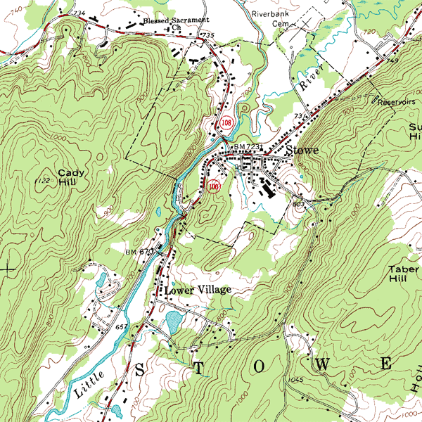
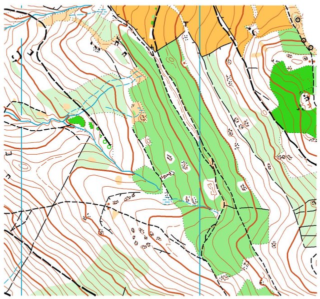
Topographic maps use the system of representation of dimensioned planes, showing the elevation of the terrain using lines that connect the points with the same height with respect to a reference plane, called level curves, in which case the map is said to be hipsographic. This reference plane can be sea level, and if it is, it will be about altitudes instead of elevations.
Action field
The topography is essential in several fields; for example:
- Surveying
- Archeology
- Architecture
- Geography
- Mining engineering
- Geographic Engineering
- Cadastral Engineering and Geodesy
- Forest engineering
- Agricultural engineering
- Civil Engineering
- Sanitary engineering
- Mining
- Geographic information systems
- Bathymetry
- Mapping
- Sewers
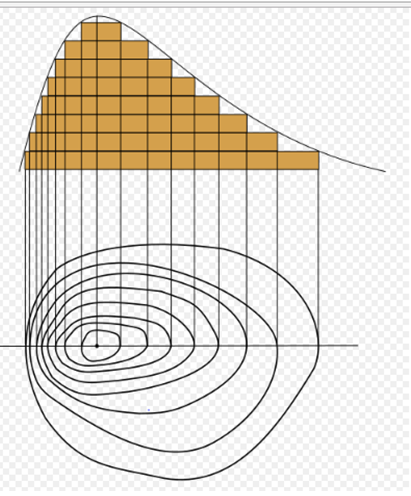
A topographic profile or topographic cut is a representation of the relief of the terrain obtained by cutting transversely the lines of a contour map, or topographic map. Each level curve can be defined as a closed line joining points of relief located at the same height above sea level.It is usually drawn on the same horizontal scale as the map, but the use of an enhanced or exaggerated vertical scale is advisable to emphasize the relief elements. This can vary according to the inclination and amplitude of the terrestrial relief, but it is usually three to five times the horizontal scale.
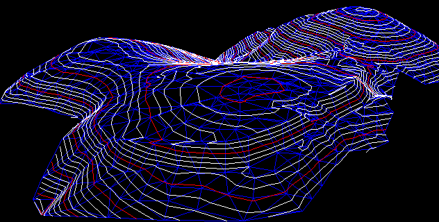
A series of parallel profiles, taken at regular intervals on a map, can be combined to provide a more complete three-dimensional view of the area that appears on the topographic map. It is evident that, thanks to computer science, more sophisticated three-dimensional models of the landscape can be made from digital terrain data.
The line of the plane defined by the points that limit the profile is called the guideline and the horizontal comparison line on which the profile, base, is constructed.
Applications
One of the most important applications of profiles or vertical sections, is in the construction of works of great length and little width, for example roads, sewers and pipelines.
Sometimes selected topographic profiles are included in the printed maps, such as those designed for navigation routes or routes, excavations and, especially, for geological maps, where they are used to show the internal structure of the rocks that populate a territory.
People who study natural resources such as geologists, geomorphologists, soil scientists and vegetation experts, among others, build profiles to observe the relationship of natural resources with changes in topography and analyze numerous problems.
Topographical works
Topography is a geometric science applied to the description of the surrounding immobile physical reality. It is to capture in a topographic plane the reality seen in the field, in the rural or natural environment, of the terrestrial surface; in the urban sphere, it is the description of the facts existing in a specific place: walls, buildings, streets, among others.
You can divide the topographic work as two congruent activities: take "the ground to the cabinet" (by measuring points or revelation, its file in the electronic instruments and then its editing on the computer) and bring "the cabinet to the ground" ( by rethinking the inverse path, from a project on the computer to the location of it through points on the ground). The surveyed or surveyed points have a three-dimensional value; that is, the location of each point in the horizontal plane (two-dimensional, north and east) and height (third dimension) is determined.
The topography is not only limited to field surveys in the field, but also has editing components and cartographic drafting, so that when making a plan the phoneme represented can be understood through the use of conventional symbols and standards, previously regulated for the representation of natural and anthropic objects on maps or topographic maps. It is also used in mining engineering.
Measurements
In surveying, elements such as measuring tape, pedometer, surveyor's square, or even the number of steps from one point to another are used.
In classical topography, to give coordinates of a point, a three-dimensional Cartesian system is not used directly, but a system of spherical or polar coordinates is used that later allows us to obtain Cartesian coordinates. For this we need to know two angles and a distance.
We distinguish two types of measurement:
The direct: it is enough to compare the distance to measure with the unit of measurement, (a tape measure on top of a table, for example)
The indirect: in which we will need a formula to obtain the measurement.
There are several instruments that can measure angles, such as the total station. For the measurement of distances we have two methods: statistical distances or electronic distanciometry, the second being more precise. For the first case we will use a tachymeter and for the second the total station. Normally the use of GPS is combined with the total station._
It is mandatory to work in the appropriate Geodetic Reference System, currently the ETRS89 in the Peninsula and the Balearic Islands and REGCAN95 in the Canary Islands. The reference ellipsoid will be the GRS80 and the corresponding cartographic projection is the UTM.
Data collection
Currently the most used method for data collection is based on the use of a total station, with which you can measure horizontal angles, vertical angles and distances. Knowing the coordinates of the place where the Station has been placed it is possible to determine the three-dimensional coordinates of all the points that are measured.
By subsequently processing the coordinates of the data taken, it is possible to draw and graphically represent the terrain details considered. With the coordinates of two points it is also possible to calculate the distances or the unevenness between the same points even if it had not been stationed in any of them.
It is considered in topography as the inverse process of stakeout, because by taking data the details of the current terrain are drawn in planes. This method is being replaced by the use of GPS, although it will always be present as coverage is not always available in the GPS receiver due to several factors (example: inside a tunnel). The use of GPS considerably reduces the work, being able to achieve good accuracies of 2 to 3 cm if one works in a kinematic way and of even 2 mm in a static way. [Citation needed] The data of altitude altimetry raised by the station are not and should not be be taken as definitive until verified by a differential leveling.
Stakeout
The redefinition is the inverse process to the data collection, and consists of capturing in the terrain details represented in plans, such as the place where to place foundation axes, previously drawn in planes. The redefinition, like the alignment, is an important part of the topography. Both are a fundamental preliminary step to be able to proceed to the realization of the work.
Stake out axes
The axes that are needed to perform the stakeout are:
- Horizontal axis
- Vertical axis
- Dimension axis
- Axis of rotation
History of topography
Currently the exact origin of the topography is unknown. It is believed that the first topographic works were made in Egypt, since there are representations on walls and tablets. In 1400 a.C. Herodotus tells Seostris to divide the lands of Egypt on land to collect taxes, creating civil service posts called "rope tenders" that are dedicated to measuring.
In Egypt, in each land of labor, a part was destined to the Pharaoh that was marked by a boundary. With the floods of the Nile River these boundaries were erased, so that each year they returned to mark the exact amount that corresponded to the Pharaoh. Pharaoh's surveyors were in charge of this task. The instructions of Amenempe, at the end of the nineteenth century (XII century BC) as transcribed by the scribe, lists the rush of the chief surveyor "the supervisor of the grain that controls the measure, who sets the harvest quotas for his lord, who register the islands of new land, in the great name of His Majesty, who records the marks on the boundaries of the fields, who acts for the king in his enumeration of taxes, who makes the land registry of Egypt ».
Other authors mark as the principle of topography Thales of Miletus and Aniximandro2, who are the ones who make the first geographical maps.
As the French geography engineer P.Merlin points out, "topography is born at the same time as private property"
The topography, as a science, has been improving in function of the technological evolution of each epoch
Below is a video where topography is explained on maps and how it relates to contour lines, or elevation points:
Bibliography :
«STUDY OF THE TOPOGRAPHIC MAP». Madrid: Institute of Secondary Education Morato García. Archived from the original on June 26, 2012. Retrieved on March 2, 2017.
https://www.brainpickings.org/2017/06/09/the-topography-of-tears-rose-lynn-fisher/