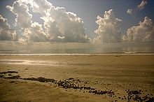
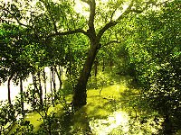
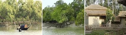
Sundarban Natural Beauty
Sundarbans is a vast forest in the coastal region of the Bay of Bengal which is one of the natural wonders of the world. Located in the delta region of the Ganges, Meghna and Brahmaputra river basins, Khulna, Satkhira and Bagerhat districts of Bangladesh and two districts of West Bengal, India, spread across North 24 Parganas and South 24 Parganas. The Sundarbans is the largest forested forest in the world as the largest mangrove forest in the coastal environment. [2] The Sundarbans, which are spread over 10,000 sq km, are 6017 sq km [3] in Bangladesh [4] and the rest is in India. Sundarbans was recognized as UNESCO World Heritage Site in 1997. The Bangladesh and Indian part of it is in fact the adjacent part of the same uninterrupted land, but the UNESCO World Heritage List has been listed in different names; In the name of "Sundarbans" and "Sundarban National Park" respectively. The Sundarbans are trapped in the net, with small streams of marine streams, mud shores and mangrove forests, small-scale archipelago. 31.1 percent of the total forest area, which is 1,874 sq km, is riverine, inlet and bills, and is a watery area. [3] Forests, well-known Royal Bengal tiger, besides many species of birds, Chitra deer, crocodiles and snakes are also known as habitats . According to the survey, 500 tigers and 30,000 chitra deer are now in the Sunderban area. On 21 May 1992, the Sundarbans were recognized as the place of Ramsar
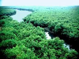
source: google.com
sundarban
source: google.com
Naming
Sundarbans literally means beautiful forest or beautiful woodland in Bengal. The Sundarbans may have been named after Sundarbans, which grow in abundance there. Other possible explanations may be that it may have been named "Sea Forest" or "Chandra-Bandhede (Dam)" (Old Indigenous). But it is generally assumed that Sundarbans have been named from the beautiful trees
Map of the Sundarbans entrance

source: google.com
History
In the Mughal period (1203-1538) a local king took the lease of the Sundarbans. Those fundamental changes that have been made in historical legal changes include being recognized as the world's first mangrove forest and under science-based supervision. The map of the Sundarbans area was prepared in 1757 after getting the rights from the Mughal Emperor Alamgir by the East India Company. The forest area is under organizational management since the establishment of forest department in India's then Bengal province in 1860 AD.
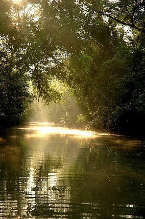
The breath-taking fairs in the watershed of the Sundarbans
source: google.com
At the beginning of the eighteenth century, the size of the Sundarbans was nearly twice the present. Human pressure on the forest gradually shrunk its area. In 1828 the British government acquired the title of Sundarbans. L. T. Hajiz conducted the first survey of Sundarbans in 1829. In 1878 the entire Sundarbans area was declared as reserve forest and in 1879, the responsibilities of the entire Sundarbans were entrusted to forest department. The name of the first divisional forest officer of the Sundarbans is M. U. Green In 1884 he served as the Divisional Forest Officer of the Sundarbans. During the partition of India in 1947, 6,017 sq km of the Sundarbans fell into Bangladesh. Which is around 4.2% of Bangladesh's area and about 44% of the entire forest area.
source: google.com
The legal rights of the first forest management department were established on Sundarbans in 1869. According to Forest Act (Section 8) of 1965, a large part of the Sundarbans was declared as reserved forest in 1875-76. Within the next year, the remaining part is also recognized for the reserve forest. This resulted in the control of forest department under the control of the remote civil administration. Later, in 1879, forest department was established as the administrative unit for forest management, with its headquarters in Khulna. For the Sundarbans, during the 1893-98 period, the first forest management plan was enacted [5] [6].
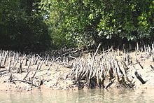
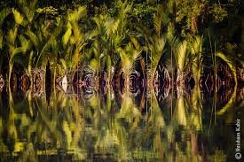
Sundarbans long mud pond
source: google.com
The breath-taking fairs in the watershed of the Sundarbans
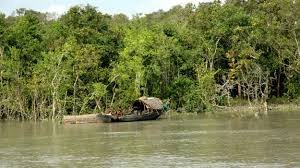
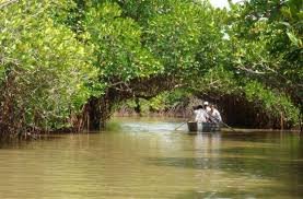
In the year 1911, the Sundarbans were termed as tract am waste land, which was never surveyed and no time has come under the census. Then the boundary of the Hooghly river is approximately 165 miles (266 km) across the estuary of the Meghna river. At the same time, it has set the inter boundary between these twenty-three Parganas, Khulna and Bakerganj districts. The total area of the reservoir, including the reservoir, is estimated at 6,526 square miles (16,902 km). Watery beautiful forests are full of tigers and other wild animals. As a result, attempts to survey could not be very successful. The name Sundarbans has been named probably by its name as Sundari (Heritiera fomes). The hardwoods found from this are used to make various items including boats, furniture. The Sundarbans are divided into rivers, canals, and inlet all over, some of which are used for the movement of both steamers and local boats, for communication between Calcutta and Brahmaputra Basin.
source: google.com
Geographic structure
As one of the three largest mangrove forests in the whole world, the Sundarbans ecosystem located in the Ganges basin is just as complex as possible. The larger part of the Sundarbans (2 6%) of the two neighboring countries, Bangladesh and India, is located on the south-west side of Bangladesh. Bay of the South; The boundary between the Balaswar river and the area of higher density of cultivation in the north in the east. In the higher areas, other water bodies except the main branches of the river are bamboo and bundled with bumper and humid land. In fact, the size of the Sundarbans was about 16,700 sq km. (200 years ago). The current volume has decreased to about one-third of the past. Currently the total land area is 4,143 sq km. (With the volume of 42 km²) and the remaining water stream with rivers, inlet and canal, 1,874 sq km. Sundarbans rivers mix salt water and sweet water. Thus, the area between the sweet water of the river coming from the Ganges, the saltwater of the Bay of Bengal, is the area. It is located in Satkhira, Khulna, Bagerhat, Patuakhali, Bangladesh. The Sundarbans is located in the southwestern region of Bangladesh.
source: google.com
The Sundarbans has been formed by depositing silt separately from the overflow due to the interstellar flow along the Bay of Bengal for thousands of years. Its geographical structure is the delta, which has numerous waterfalls on the surface and ground water and mud pellets. In addition, the perennial grasslands, sandfire and islands, which are high in the middle of the mean sea level, are covered by the net, the canals, the underwater walls, the original algae mud and stored sediments. The height of the Sundarbans from the sea level is 0.9 meters to 2.11 meters [7].
Biological components play an important role in the process of marine matter and animal diversity. The diverse variety of beaches, estuaries, permanent and transient wetlands, mud ponds, inlet, sand dunes, and clay stacks have been formed here. The mangrove plant world itself plays a role in the formation of new land. Again, in the process of transplantation of water in the interstellar plant world plays an important role. The presence of mangrove organisms creates zodiacal ecosystem in interstellar mud ponds. It holds the policy for the production of horizontal subcutters for seeds. Ananta sandalese organization and evolutionary processes are controlled by a large number of xerophytic and halophytic trees. Trail-leaf, grass and hogla stabilize the formation of sand and unorganized polystars.
Climate change effect
The formation of the Sundarbans along the coast is influenced by the multidisciplinary factors, including the flow of streams, the bustle and aggregate stream cycles and the long coastal streams of the sea coast. Seawater currents vary considerably in different seasons. They also vary due to cyclone.
source: google.com
Deterioration and accumulation through these, although still not able to accurately measure, it creates a dimensional difference in the nature of the changes. However, the mangrove forest itself plays a significant role in its stability. During the seasonal rainy season, the entire Bengal Delta is submerged in water, most of which are submerged in almost half the year. The underlying sediments of the basin are primarily due to seasonal rainfall during the monsoon season and events like cyclone. In the coming years, the biggest problems faced by the people in the Ganges Basin are the increase in sea level rise.
The National Environment Court is also concerned because the mangrove forests against the marine storms, which are standing along the Sundarbans as well as the south-south natural wall, are not enough to save them.
Biosphere
Two types of biosphere are found in the Sundarbans: forests of wetlands of wetlands and mangrove forests.
Forests of freshwater wetlands
Forests of the Sundarbans, the wetlands of the Sundarbans, belong to the tropical humid forest of Bangladesh. Examples of such forest-type wetlands The freshwater saltwater reservoir is slightly salted and this salinity decreases slightly during the rainy season, especially when the water of the Ganges and Brahmaputra drains the nanazal and the thick layer of clay layer is deposited.
Plant diversity
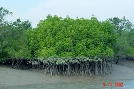
The main forest variations of the Sundarbans are rich in heritiera fomes, excoecaria agallocha, ceriops decandra and keura (sonneratia apetala). According to Pren's 1903 publication, there are a total of 245 species and 334 species of plants. [10] After Prine's report there has been a significant change in mangrove species and their classification [11]. The nature of the forest has been searched very rarely to keep track of these changes. Although most of the other mangroves in the world have the capacities of Rhizophoraceae, Avicenneaceae or Laganculariaceae, the trees of the Sterculiaceae and Euphorbiaceae tree [14] in the mangroves of Bangladesh.
Beautiful tree
source: google.com
There is a great difference between plant life flow in the mangrove forests of Bangladesh compared to other coastal mangrove forests and highland forests which are not deltaic. The importance of Rhizophoraceae less than the previous. Variations of plant life cycle have been explained on the basis of the effects of pure water and low salinity in the Northeast and on the basis of water extraction and poly-storage.
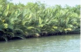
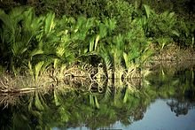
Sundarban's famous palm tree
source: google.com
Sundarbans has been classified as a humid tropical forest which has been developed on the well-lit beach of Sonora (Sonneratia apetala) and other coastal trees in the main forest. Historically, there are three main types of plants in the Sundarbans, which have been identified based on the depth of the salinity in the water, the extent of fresh water flow and the extent of the relation of the geology.
Sundarban's famous palm tree
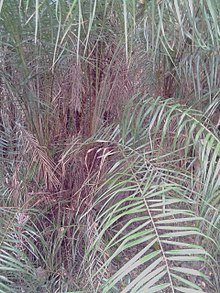
Rattan tree
source: google.com
As well as the beauty and grace of Gaya throughout the region, there are sporadic (Xylocarpus granatum) and keora (Sonneratia apetala). Among the grasses and shrubs is Poresia coaractata, Myriostachya wightiana, Shan (Imperata cylindrical)], Phragmites karka, Gulpata (Nypa fruticans) are well organized. Kheora refers to the newly formed sludge and this species is important for wildlife, especially for the Axis axis. Alongside the forest, along with the vast area of the Sundarbans, the saltwater and sweet water reservoirs, the inter-riverplough, the shelf, the sand, the open grassland and the areas of trees and shrubs
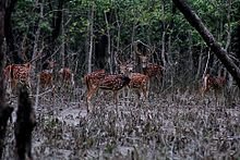
Wildlife
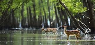
Chitra deer group in the Sundarbans - Charged, exhausted in the presence of outsiders.
source: google.com
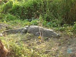
A crocodile in the Sundarbans.
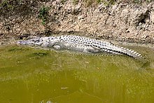
source: google.com
Crocodile Crores grown in the Sundarbans crocodile farm

source: google.com
There is a wide variety of wildlife in the Sundarbans. Livelihood Conservation Management In some areas of the Sundarbans, it is like a restricted sanctuary, where uncultivated forest resources can not be collected and there is little disruption in wild life. Although it is clear that livestock resources of Bangladesh have decreased in recent years [5] and the Sundarbans are not beyond this. Yet the Sundarbans has survived many species of progeny and other related species. Among them, Tigers and Shushuks are being planned with preservation and preservation management and tourism development.
In the Sundarbans Blue Grecia fish farming also seen
source: google.com
Honeycomb in the Sundarbans tree
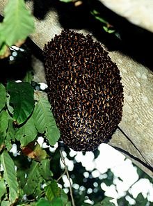
source: google.com
The situation of both the situation in the opposite environment and the conservation management in the risky condition is a strong indicator of overall wildlife and conservation management. According to 2004, Sundarban 500 is home to the Royal Bengal Tiger, which is the single largest part of the tiger on the planet [15].
In the Sundarbans Blue Grecia fish farming also seen.
Ecology of the Sundarbans is of basic nature and which is a vast place of wild animals. The number of wild animals and their habitat and the management of forest management are very much affected. Turtle (Kaito Turtle - Betagur baska, Sondhi Kachim - Lissemys punctata and Smooth cartilage - Trionyx hurum), Lizard yellow monitor - Varanus flavescens and Water monitor - Varanus salvator, Python molurus and Panthera tigris tigris One of the local species of Sundarbans.
A crocodile in the Sundarbans.
Crocodile Crores grown in the Sundarbans crocodile farm
Some of these species are preserved, especially by the Bangladesh Wildlife (Conservation) (Amendment) Act, 1974 (P.O. 23 of 1973). Various species of deer (Hog deer - Axis procinus and Swamp deer - Cervus duvauceli, Bubalis bubalis), Javandial rhinoceros - Rhiniceros sondaicus and Indian rhinoceros - rhinoceros unicornis) and some species of freshwater crocodiles (Crocodylus palustris) have become rare in the Sundarbans From the beginning of the 21st century [16].
source: google.com
Recent studies have shown that the diverse biodiversity reservoirs are commercially important in the Sundarbans commercially important 120 species of fish, 270 species of birds, 42 species of mammals, 35 reptiles and 8 amphibian habitats. This suggests that there are a large number of species of different species in the Sundarbans (such as 30% reptiles, 37% of birds and 37% mammals) and a large part of them is rare in other parts of the country [17] Of these wildlife, Sarker has noted that two amphibians, 14 reptiles, 25 aves and five mammals are presently endangered. [16] According to the government, the two species of amphibians, 14 species of reptiles, 25 species of birds, and 5 species of mammals are currently under threat [13]. Sunderbans is a paradise for bird scientists in bird watching, reading and research [18]. In the meantime, many species have been extinct, including wild buffalo, para deer, wild ox, small and big horn rhinoceros, bar horn, leopard tiger. The white manic pair of earrings, spun ducks, goggles, and other birds of the lake
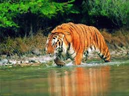
Sundarban Tiger
According to 2004 estimates, the Sundarbans is home to around 500 Royal Bengal Tiger Tigers, which is the single largest part of the tiger [15]. These tiger countless people, about 100 to 250 people per year, are widely known for their killing. They are not the only tiger near the boundaries of human habitation. Surrounded by the tiger's surroundings, such attacks on humans are rare. There is no news of any deaths due to the tiger attack of the Indian part of the Sundarbans due to various measures taken for security. On the other hand, in the Sunderbans of Bangladesh, more than half of the tigers died in the chronology from 1981 to 2004. [19]
source: google.com
Local people and government officials take various safety measures to prevent the attack of tigers. Local fishermen celebrate the journey of Banadevi Banwibi and performing religious rituals before starting the journey. It is important for the local population to pray for safe wander in the Sundarbans. Since the tiger always attacks from behind, fishermen and woodcutters are wearing a mask behind their head. Although the system worked for a short time, the tigers understood the tactic and started attacking again. Government officials wear hard pads like a pad of American football players, which cover the back part of the neck. This arrangement is done to prevent the biting of tigers in the spine, which is their preferred attack strategy.
Fish resources
There is no scientific research done on the overall fish of the Sundarbans. As a result, there is no data available on the present condition of fish, extinct fish, and extinct fish. Just the fish that fish eat and fish which are suitable for export, the fish have been identified. It is believed that there are about 300 species of fish in the Sundarbans. According to Sedenstalker and High (Perspective 1978), there are 120 species of commercial fish; However, according to Bernankece, (2000) there are 84 species of commercial fish, 12 species of crab shrimp, and 9 species of snails.
Fisheries resources are divided into two parts of the Sundarbans. All fish are white fish, the rest are bugada, lobsters, crabs. [3] After the harvesting of shrimps in the 1980s, the abundance of fish decreased suddenly. At one time, 80 percent metatow fish in local public protein. Now the fate of the fishery is in the alliance of very few people in the area. In the Sundarbans, black sharks, elasha kamat, leuk kamat, kanua kamat are found. Earlier it was available to the Khalishpur area, now (2010) many have moved south. They have high prevalence in the Sundarbans. These numbers are very low, especially the black shark can not be seen almost. Most of the nine species of Shanklapatra fish (2010) are not found in the Sundarbans creek area. [3]
source: google.com
Five species of crocodile Kamila-Fishes are very bad in the state of quicchus and paddy quiche. The locals did not eat these fish to look like left fish in the previous day. Still does not eat But thousands of crab fishes used to catch cucumbers in fishery pieces as barks to catch. Winter fish or archery fish could be seen in almost alluvial water in the seafront Jungle Valley. These fish-shaped fish-shaped fishes take one-and-a-half feet of water after eating ant or insect-shaped insects in the trees, sprinkle them with irrigated water like irrigation and soak the insect into the water and eat it. This fish is taller feet in the full-age. I do not see these fish anymore. At one time the name of the java fish could have been heard, they were 55 centimeters long. Now the (2010) is the burden seen. Very tasty fish like pigeon or pigeon is nowadays falling in fishermen's net. [3]
source: google.com
The most familiar fish in the Sundarbans is Parash fish. The fish could be found in large quantities in the jungle for up to 16 cm long. There are very few still available. Parashee's cast-iron cast lots. Reduce the fall, fall in the red, and nowadays fewer detectable. Very tasty fish; Many of them are not seen in the river-canal. [3]
There is a deadly poison in the throats of the deadly ears of Kan Magur. Though some of the big ears are still available (2010) Dagi Kan Magu is now extinct. Although the Tangra variety Gulsha Tangra, Nona Tangra is still available, large size Shillong fish are almost extinct. Kajolis fish are not easily seen. Wonderful beautiful fish fish. The biggest fish in the Sundarbans is now caught, but now it is found in Kalvadre. Earlier, the Ugly Philosophy of the Sundarbans was caught in the Gangaigheya fish boro, but now it is not available (2010). The line of fish was seen quite a bit, it was not seen lately. [3]
Although red datina is still available (2010) red datina is absolutely rare. Very delicious laksha fish (local name: Tariyal Fishes: Indian Salmon) in the middle of the Sundarbans river-khari, runs a small stir, spreads in small, medium pars, and datina fish. They are about four feet tall in size. Like them, the Tapsa fish (local name Ramsushosh) has appeared in Akal (2010). Fishermen, at least five species of Cheua fish, in the big river. Red Chewia has become endangered. The symbol of the Sundarbans and all the tropical mangrove forests of the world is the fish called Mud Skipper, also known as Dahooch Fish. Five species are found in the forest. They range from 9 to 22 cm in species. [3]
In Baleswar forest of forest, enough hilsa was caught in Kunga river. Chandana hilsa is available in two species of hilsa (2010). Ram fasa is available in 4 species of fish fish (2010). The number of monogamous fish decreased. In the Sundarbans, the medium-sized bills of the bridges, inhuman, jongra, subdi-gubdi are stuck in the rainy season, the tide of water goes in some places. The water of these bills is sweet, here sweet fish are found. Most jol fish Whereas, horns, magura, two species of Taki, other than Shol, there are small fish like tangra, patty, cavity, chala, karkhina, buds and other fish. Because of the global warming, these billions of water are entering the water. These bills are counting the end of the fish. [3]
Economy
The Sundarbans population is more than 4 million [20] but most of them are not permanent population.
In the southwestern economy of Bangladesh, as well as in the national economy, the Sundarbans also play an important role. It is the single largest source of forest resources of the country. These forests provide raw materials in wood based industries. Apart from traditional forest produce such as timber, fuel and mud, the forest is regularly extensively collected from the forest, such as house leaves, honey, beeswax wax, fish, crabs and snails-mussels. This land of the Sundarbans of the Sundarbans, along with the necessary habitats, nutrition producers, water purifiers, silt collectors, storm preventants, coastal shelters, power reserves and tourism centers.
source: google.com
This forest plays a very resistant and productive role. The Sunderbans, contributing to the total income of forests, accounted for 41 percent of the country's reserve forests, and contributed 45 percent (World Food Agency, 1995) to timber and fuel production. Many industries (such as Newsprint, Diesel, Hardboard, Boat, Furniture) are dependent on raw materials derived from the Sundarbans. Various non-wood resources and forestry created significant employment and income opportunities for at least half a million coastal population. Alongside the productive role, the Sundarbans also play a role in the cyclone-hit Bangladesh's coastal population and the natural security of their property.
Between 1959 and 1983, the proportion of forest resources has decreased mainly in the case of two mangrove species - Sundari (Heritiera fomes) and Gewa. The reduction amount was 40% and 45% respectively (Forrestal 1960 and NADA 1985). Moreover, despite the complete restriction of other wildlife victims other than fish and some invertebrates, there is an indication of decrease of biodiversity (in this century, at least 6 species of mammals and 1 species of reptiles) and consequently the quality of ecosystem is decreasing (IUCN 1994).
Reserved area
Indian National Park and Sanctuary
The Sundarbans National Park in West Bengal consists of a national park or National Park, Tiger Reserve and a biosphere reserve. It is located on the Ganges Island and the western part of Sundarbans adjacent to the Sundarbans in Bangladesh. The delta area is covered by dense mangrove forests, and one of the largest dwellers for the Bengal Tiger. There are various species of birds, reptiles, with crocodile in salt water. At present the Sundarbans National Park was declared as the main area of the Sundarbans Tiger Reserve in 1973 and Wildlife Sanctuary in 1977. On 4th May 1984 it was declared as National Park.
source: google.com
Sajnekhali Wildlife Sanctuary is a Wildlife Sanctuary located at Sajnekhali in the Sundarbans of south 24 Parganas district of West Bengal, India. Its area is 362 sq km In 1960, the West Bengal government declared it a sanctuary and was re-announced in 1976. [21]
Welcome to the Sajnekhali wildlife sanctuary
Wildlife Sanctuary in the Halid Island
Wildlife Sanctuary in the Halid Island is a wildlife sanctuary located in south 24 Parganas district of West Bengal state of India. This sanctuary is located in the mouth of the Matla River near the Bay of Bengal with about 6 sq km of forest. It was declared a sanctuary in 1976. [22] [23]
Lothian Island Wildlife Sanctuary
Lothian Island Wildlife Sanctuary is a wildlife sanctuary located in the south 24 Parganas district of the Indian state of West Bengal. This island is located in the mouth of the Seven-Point River near the Bay of Bengal. In 1948, the forest was declared the first sanctuary and in 1976 it was re-announced. This sanctuary is part of the Sundarbans delta. [24]
Bharatpur Kumari project, leaving the national parks and sanctuary, Sajnekhali birds in Indian Sundarbans.
The sanctuary of Bangladesh
The Sundarbans area of Bangladesh is about 4,110 sq km. The river, canal and inlet are about 1,700 sq km. Whose width ranges from a few meters to a few kilometers Till Due to interconnected waterways, it is easy to navigate easily in almost all places of the Sundarbans. The management of the Sundarbans consists of two forestry departments, four administrative ranges - Chandpai, Sharankhola, Khulna and Burigolini and 16 forest stations. The forest is again divided into 55 compartments and 9 blocks. [2] In 1993, Khulna Forest Circle has been formed in the form of a conservator for forest conservation. The post of administrative head of the Department is from Khulna. For implementing necessary management and administrative decisions, there are a number of professional, amateur and supportive manpower under the Divisional Forest Officer. The central unit of management is the compartment. The 55 compartments, under four forest ranges, are divided according to natural characteristics like rivers, canals, inlet.
Three sanctuaries in Bangladesh have been established [19] In 1977 by the Bangladesh Wildlife Preservation Act, 1973 (P.O. 23 of 1973). These are:
source: google.com
Eastern Sundarban Wildlife Sanctuary: Area is approximately 31,227 hectares. Gita (Excoecaria agallocha), P. and Keora (Bruguiera gymnorrhiza), along with sweetness and beautiful plants (Heritiera fomes), includes flood prone areas. Singra (Cynometra ramiflora) is relatively dry ground, Amur (Amoora cucullata) is in the waterfalls area, the grilled (Ceriops decandra) is in the salted area and the round leaves (Nypa fruticans) are along the waterway.
Southern Sundarbans sanctuary covers a wide area of 36,970 hectares. There is evidence of huge seasonal variation of salinity in the area. The main tree species in the relatively long-standing saline area include Gueva. It is often grown in places where the beauty is not able to successfully resemble.
The western Sunderbans sanctuary is located at 71,502 hectares of area. The relatively dry land of this area and the river Gewa, Garna and Hantal were born