National Park Dinira. States Trujillo, Lara, Portuguesa - Venezuela.
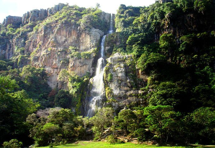
Photo: ivenezuela.travel
Declaration: Decree No. 2,564 of November 30, 1988.
Official Gazette No. 34,120 of December 22, 1988
Location: In the Sierra de Barbacoas. It covers the states of Lara, Trujillo and Portuguesa. In the jurisdiction of the Morán and Torres municipalities of the Lara State; Boconó, Juan Vicente Campo Elías, Carache of Trujillo State and Monsignor José Vicente Unda of the Portuguesa State.
Altitude: 1,160 - 3,585 meters above sea level.
Area: 45,328 ha
Climate: Temperate tropical height.
Temperature: Between 4º C - 20º C
Precipitation: 1,300 mm.
Characteristics.
Physical: Its name Dinira, which means spring, is what the Aborigines Gayones, indigenous inhabitants of the place, people of linguistic affiliation Macro - Chibcha, gave to the whole mountain located west of the city of El Tocuyo.
This reference was reviewed in the report sent by the Mayors of the aforementioned city, to King Felipe II in the year of 1579, whose description was also accompanied by a map of the time. These documents were published by the National Academy of History, in the book Geographical Relations of Venezuela, compiled by the historian Antonio Arellano Moreno in 1964. The National Park Dinira, located in the Cordillera de los Andes, constitutes seat of the Basin Alta del Río Tocuyo, which drains into the Caribbean Sea.
As well as the upper basins of the Chabasquen and Boconó rivers, which drain into the Western Plains and the Upper Carache River Basin that flows into Lake Maracaibo. It is characterized for being a mountainous landscape with steep topography, with valleys in the form of "U" and terraces.
Here is born the most important river of the western central region of the country, the Tocuyo River, which is formed by the confluence of the streams: Soap, Badilla, Aranda, Porras, El Vino and Chorro Torcido.
The National Park Dinira located in the Sierra de Barbacoas, is part of the spurs of the foothills of the Andes that enter Lara State. In the Dinira National Park, there are attractive waterfalls such as the spectacular Cascada del Vino, with 90 meters of drop, named for its characteristic color, produced by the mixture of Antocianina, substance contained in the plants found there, with the material ferruginous that comes off the rocks.
It has numerous caves of Karstic origin, product of unique geomorphological phenomena, among which the Peony in Barbacoas stand out. In the highest parts there are lagoons probably of glacial origin of great tourist and scientific interest.
Highlights: Dinira National Park
It was created with the objective of preserving biological, geological, cultural and landscape resources of national importance. The rivers, waterfalls, lagoons, extensive and dense forested masses, curious valleys and high peaks, large caves and exciting moors, have been linked to create a landscape of great scenic value and protector of the invaluable resources that remain in the Dinira National Park.
The cave of Pelastic origin, close to the town of Barbacoas. It has numerous zoned sites for recreational areas such as: In the North sector there is the Cascada del Vino, where you can make immersion baths, camping, hiking by means of penetration routes and / or by well-defined trails and trails. It offers its visitors camping sites, kiosks, sanitary facilities, parking and other services. In the East sector, known as Buenos Aires, window to the páramos Cendé and Las Rosas.
Flora: Vegetation in the Dinira National Park is made up of submontane, ombophilous forests, evergreen montane (Andean cloud forests) and Andean páramos.
Dinira National Park has four types of vegetation: forest, páramo, forest plantations and savannahs. In these forests, the presence of 42 species of large canopy trees has been determined in 626 individuals studied.
Among the predominant species are: the cobalonga Sloanea caribaea, the spoon Simira erythroxylon, the yellow naranjito Zanthoxylum ocumarense and the araguaney Tabebuia chrysantha. The páramos occupy an extension next to 5% of the park, with heights that vary between 2,600 and 3,600 msnm. The most extensive sector corresponds to the Páramo de Cendé whose summit, the highest in the park (3,652 meters above sea level), shows several species of Espeletia sp. The forest plantations show an extension of 2,000 ha approximately, the species that are found here are Eucaliptus sp., Cupresus lusitanica, Fraxinus sp., Acacia decurrens, Pinus radiata and Pinus caribaea. There are also endemic botanical species such as Diocodendron dioicum and Miconia larensis.
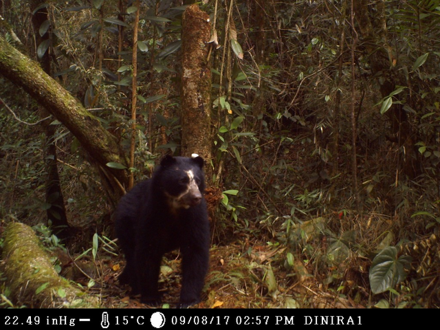
Frontino Bear.
Photo: minea.gob.ve
Fauna: The fauna in the Dinira National Park is abundant and varied, among mammals there are endangered species such as the wild bear or frontino Tremarctos ornatus, deer such as the matacán or candelillo Mazama rufina, big cats like the tiger Panthera onca, the Puma Felis concolor and the cunaguaro Leopardus pardalis; In the bodies of water you can see the water puppy Chironectes minimus.
The birds present beautiful specimens, valuable for their song and beautiful plumage, such as the cardinal Carduelis cucullata, very persecuted to cross it with the canary, obtaining a hybrid of beautiful red color and melodious song, which caused the reduction of their populations.
Recommendations and Standards
Avoid the spread of garbage in the park areas.
Use only biodegradable soaps such as blue soap, they do not pollute the environment.
Camp in the areas designated for this, travel along the routes and paths already defined.
Use only stoves and gas lamps. It is not allowed to light fires.
Respect the flora and fauna. The sound equipment disturbs the natural environment of the park.
Do not damage or mark natural and cultural elements.
To carry out any activity in the Dinira National Park, it is necessary to request authorization.
It is reached by road following several routes, which leads to the city of El Tocuyo, Humocaro Bajo and Humocaro Alto, through a gravel road. Or on the Pan-American Highway, on an asphalted road, you can access the towns of La Pastora, El Jabón and San Pedro, until you reach Barbacoa
Also by way of Trujillo State via Carache - La Peña.
Activities
Excursions and walks: Routes Paramo Los Nepes, Páramo Las Rosas and El Cendé.
For more information, contact the Regional Office of INPARQUES Lara, located in the José María Ochoa Pile Recreation Park. Los Leones Avenue, next to the 13th Army Infantry Brigade. Barquisimeto, Lara State or the INPARQUES Trujillo headquarters located on 11th Avenue, with 12th Street, Pabón Building, Level Nº. 1, Office number 4, Centro, Trujillo, Trujillo State.
Information sources: guiaviajesvirtual.com & aventuraecologica.blogspot.com