PANORAMA ROUTE ALONG BLYDE RIVER CANYON, SOUTH AFRICAN TRAVEL BUCKET LIST!
Gondwanaland broke apart- Madagascar and Antarctica tore free from Africa some 200 million years ago. Vast ancient shallow sea, stretching west beyond Pretoria, with its weight gradually tilted upwards the broken edge of the continent. Layer of dolomite and sandstone were left behind and laid down over millions of years as sediments.
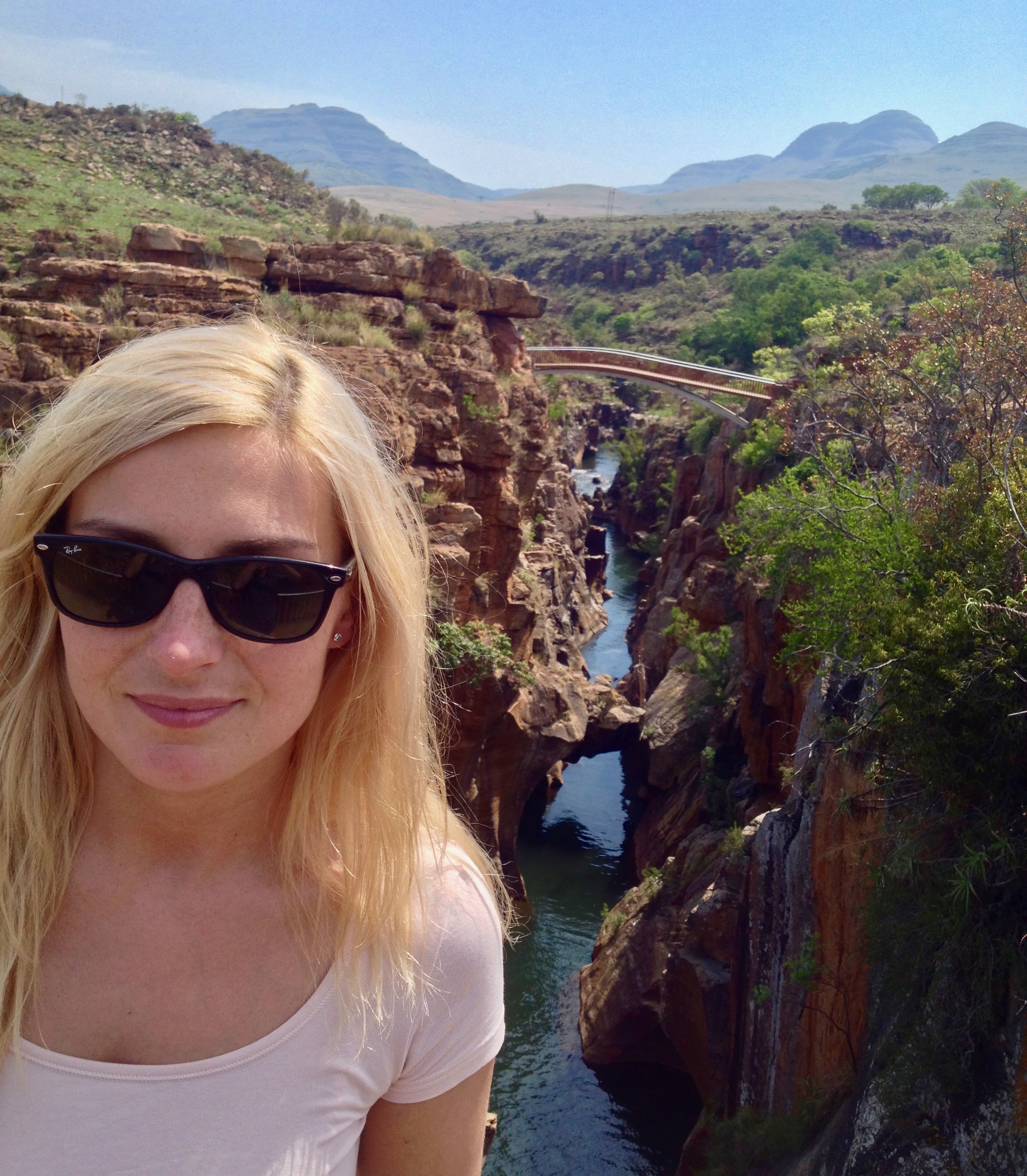
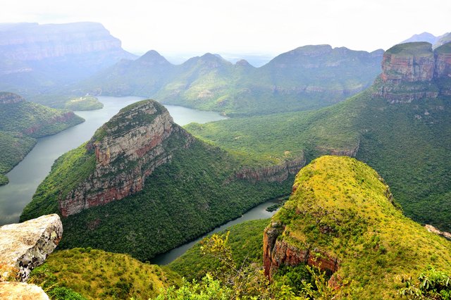
Blyde River Canyon Nature Reserve is the 22 500-hectare area, with elevation that varies from 560 m to 1,944 m above sea level. Its part, The Blyde River Canyon is carved out of red sandstone and forms the third largest canyon in the world. Centred around the Reserve is spectacular 'Panorama Route' a mountain scenery and panoramic views.
In the Canyon, three round, slightly pointed mountain tops stick out, the Three Rondavels. Called this way because they resemble traditional oval African homesteads. Due to the slow erosion of underlying soft stone, the shale and quartzite was exposed creating these breathtaking formations.

It's a very diverse flora with a variety of habitats. The reserve's vegetation is around 1,000 plant species, classified as the Northeastern Drakensberg High-Mountain Sourveld ecoregion of afromontane forest, riparian forest, moist woodlands, grassland slopes, grassland plateaus, wetlands and sponge areas, shrublands and dry woodlands.
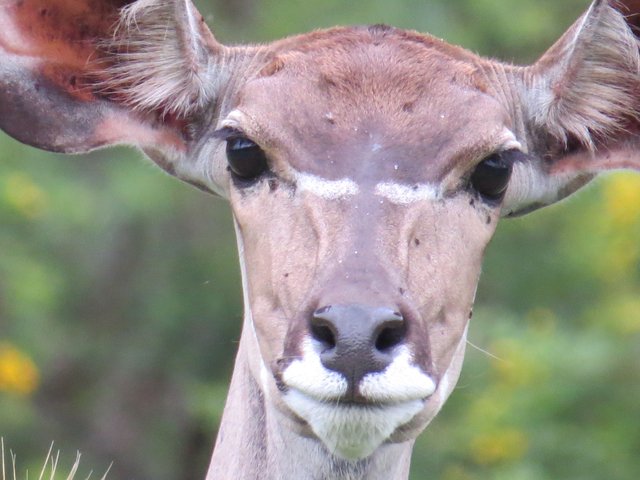
Zebras, impalas, blue wildebeests, kudus and waterbucks are inhabitants of lowveld area. The mountains and cliffs are home to a number of raptor birds and mammals like rock hyraxes, mountain reedbucks and baboons.
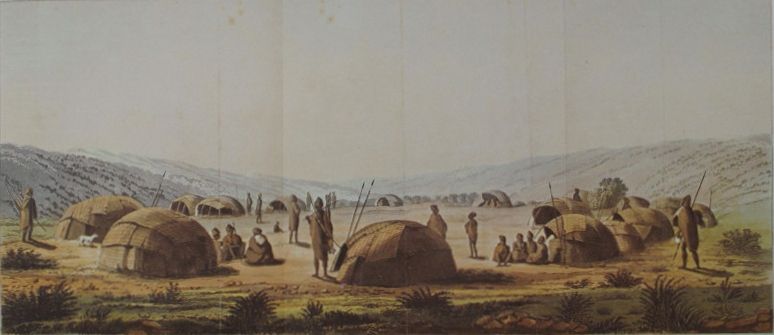
As can be deduced from the stone tools, engravings and rock paintings, found in the area, the San people also commonly known as Bushmen, were the earliest inhabitants of the Mpumalanga Escarpment.
The Stone Age and Iron Age peoples along with their domesticated stock, found refuge in these most inaccessible and remote valleys and gorges. They were introducing the basic concepts of farming and as the archaeological excavations shows, working metals.
Immigrating southwards along the interior plateau, came Basutu-Bafadi people. Moving southwards, east of the Lebombo mountains the Nguni Groups with Swazi people. This encounter resulted in Swazi defeating the Basutu and in 1820 the remaining Basutu people, being finally absorbed by consecutive riding Zulu and Shangaan parties.
The area has always been malaria-free, it was great for base camps, established by the
pioneers, who in the days of gold rush hunted for birds and explored the Lowveld. Many leaders of the Boer Nation, transport riders, foresters and engineers were included in the areas rich history.
In 1871 a rich gold reef was discovered, gold-rush started and the camps soon became towns, parts of the route were used as a transport road.
To supply firewood and mine props many indigenous forests around Sabie town were destroyed, but in 1876 the first commercial trees, like an exotic pine and eucalyptus were planted. These plantations became one of the world's largest man-made forests.
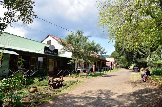
The surrounding region is undeniably filled with history.
Pilgrim's Rest, declared a gold field in 1873 is a National Monument. Frozen in time quaint town is a living reminder of the past. Old Transvaal Gold Rush, made about 1500 diggers work in this area. Beta Mine was active until 1971. Gold mining resumed in 1999 in the hills around Pilgrim's Rest, with the Tranvaal Gold Mining Estates.
Established in 1849 Lydenburg became an important wagon route, free of British control. In 1874 arrived the first wagons from Delagoa Bay.
It is also known for its pottery artefacts. Amongst many bone fragments, iron and copper beads and ceramic vessels, terracotta heads are the earliest known examples of African Iron Age (approximately 500 A.D) sculptures in Southern Africa.
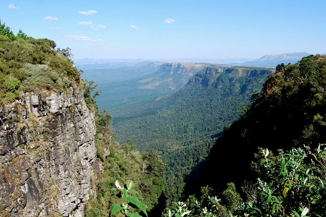
In the close proximity of forestry town Graskop, amaze wonders such as Gods Window, with its more than 700m cliffs drop and panoramic view of the Lowveld, into lush indigenous forest and ravines.
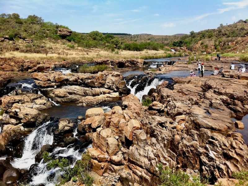
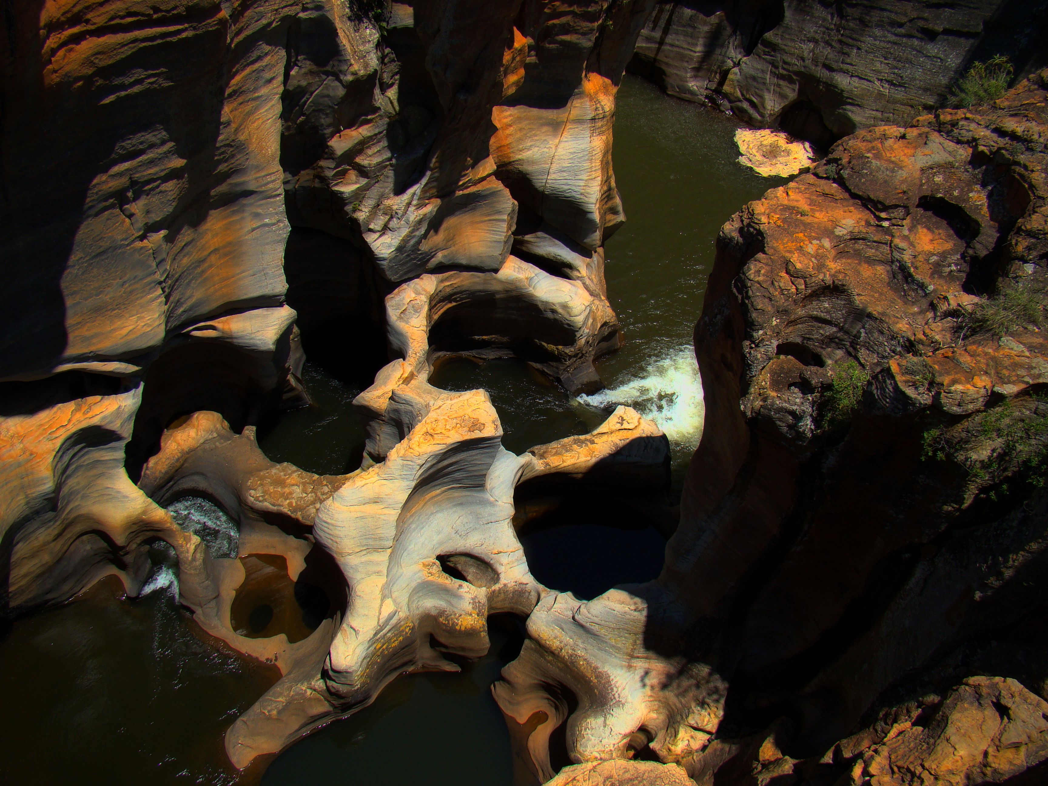
Named after a prospector, who staked a nearby claim, Bourkes Luck Potholes are a geological formation with series of smooth cylindrical rock sculptures, filled with dark brackish water, carved into the sandstone bedrock. It is a result of decades of extensive water erosion. Tom Burke unfortunately had no luck here.
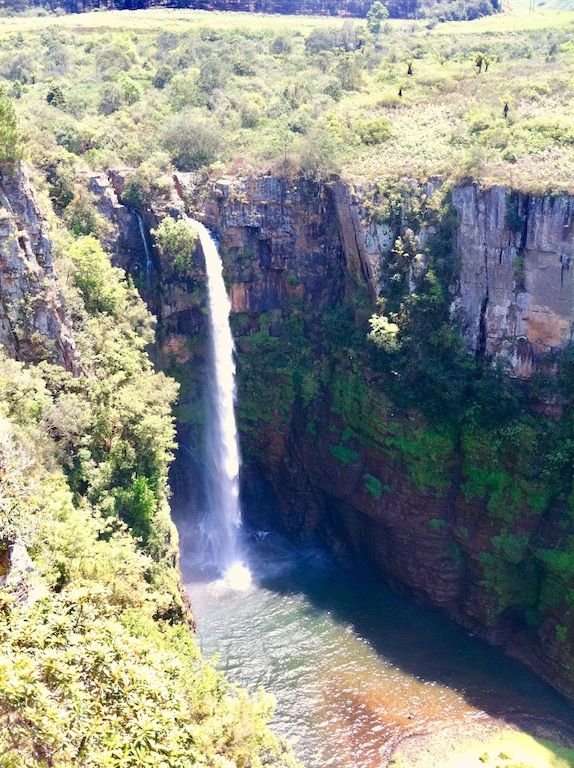
One of many magnificent waterfalls in the area, Mac Mac Falls, declared National Monument, plunging some 70m into once gold baring gorge below. Twin falls revert to one during the dry season.
The neighbouring Kruger park, named after the ZAR President Paul Kruger hosts the Big Five: lion, leopard, elephant, rhinoceros, and buffalo, more than 130 types of mammals and 500 types of birds and it is the oldest game park in South Africa.
References
*Photographs taken by @highonthehog
*Other sources : linked below photographs,
C. Rowe, Heritage Management Of Archaeological, Historical And Industrial Resources On The Blyde River Canyon Nature Reserve, University of Pretoria , 2009
H. Bornman, Pioneers of the Lowveld, SA Country Life, 2006
A.P. Cartwright, Valley of Gold Littlehampton Book Services Ltd, 1974
O wow, it looks just amazing.
Look at all those pictures, breath taking views. That tore part looks like a scene from any Hollywood movie lol
I would like to ask, as an traveler, what is the biggest challange/problem you face/have faced?
Being A SteemStem Member
where is the horse ass ? :D
damn , you are right , forgot about it. Well this time you need to settle with this thumbnail 'ass' XD
hahaha :D looking for the next one then :)
very beautiful and you are very lucky to get there
I really like
Congratulations @highonthehog! You have completed some achievement on Steemit and have been rewarded with new badge(s) :
Click on any badge to view your own Board of Honor on SteemitBoard.
To support your work, I also upvoted your post!
For more information about SteemitBoard, click here
If you no longer want to receive notifications, reply to this comment with the word
STOPWow,. Incredible, thank's @highonthehog
Congratulations, Your Post Has Been Added To The Steemit Worldmap!
Author link: http://steemitworldmap.com?author=highonthehog
Post link: http://steemitworldmap.com?post=panorama-route-along-blyde-river-canyon-south-african-travel-bucket-list
Want to have your post on the map too?
The pictures are great. Nature is something very beautiful.
I love the green moss on the rocks! It makes the landscape look so fresh and ready to be explored ❤️
Beautiful nature and landscapes The photo of Celso Flores remind me Blue Mountains in Australia I mean it is similar and it is just my impression