TRAVELING EXPLORING MOUNTAIN (LEUSER) Part 2
Hello friends Steemians all hopefully always in good and healthy always..!!!
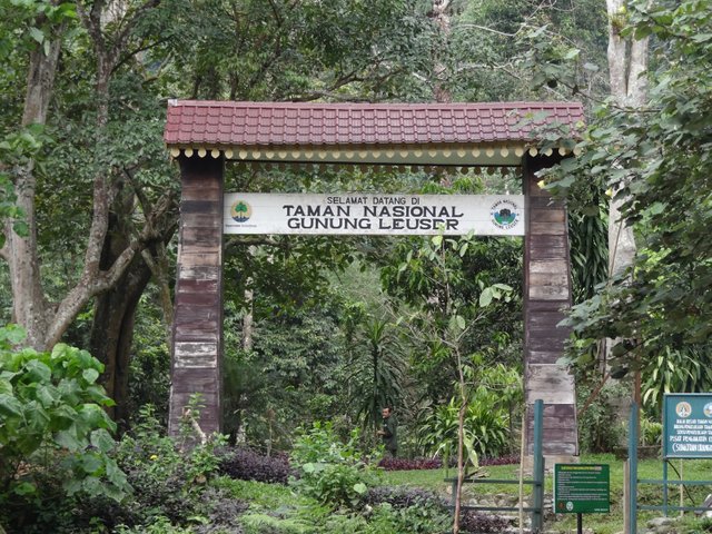
on this part two I will explain about the path and licensing in climbing Gunung leuser tour.
The Kedah-Leuser Return Trek
The Leuser Range is one of the most remote regions of Indonesia (along with parts of Papua and Kalimantan). With an experienced guide and sound porters, it is an exhilarating but long and, in some parts, tough trek. Allow at least 12 days in total, including for bad weather/rest and 2-3 days on the Leuser Range if you plan on climbing all three peaks.
Treks normally start at Desa (village) Kedah, Kecamatan (sub-district) Kuta Panjang, Kabupaten (district) Blangkejeren. There are two options: Kedah-Leuser-return, by the same route (12 days – about 120 kms); and, a much more difficult one-way route, Kedah-Leuser-West Coast (14 days), emerging somewhere near Manggeng or Labuhan Hajji on the west coast of Aceh. The latter is a serious undertaking requiring very experienced guide/porters and food carried from start to finish. For the Kedah-Leuser-return trek, food drops can be made en route thereby progressively reducing loads.
Start Point: Kedah (1,200 m) is reached from Medan by car in one long day (or two days over-night at Brestagi, Kuta Cane or Ketambe). Kedah can also be reached from Bireuen, in northern Aceh, via Danau (lake) Takengon in the Aceh central highlands but this takes much longer time.
Guide and Porters: We began our trek at Rain Forest Lodge, operated by Pak Rajajalli (Jalli), 0813 6229 1844. https://pendakianleuser.wordpress.com/ . Pak Jalli has much accumulated knowledge and experience having trekked in the region since 1981 and is dedicated to the conservation of the Gunung Leuser National Park. He will arrange guide/porters and permits.
source image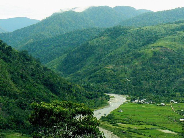
Fees/Permits: as of August, 2014, the Gunung Leuser National Park authorities have set fees per trekker per day: Indonesian – Rp 50,000; foreigner – Rp 150,000. Bring photocopies of ID/passports. Your guide will arrange permits. For safety purposes, parties must be accompanied by an experienced guide and consist of a minimum of three persons.
Maps: The relevant BAKO maps are series 50-0-ed, 0519-63, scale 1:50,000, 1977. The trek from Kedah to the Leuser Range is within this map. A second map, to the south, is needed for Gunung Leuser. These maps provide an overview of the terrain but, with a guide and GPS, are not essential. Ask your guide the Gunung Leuser National Park brochure: Pendakian Gunung Leuser 3,119 MDPL (Climbing Mount Leuser 3,119 m ASL) that shows the trek and camp sites superimposed on a satellite photo of the region.
Trekking Season: northern Sumatera has two drier periods: February-March and July-August. The latter corresponds with university holidays when many groups undertake the trek. The Leuser trek is becoming increasingly popular amongst Indonesians and foreigners – some 10 groups in 2010, and 30 in 2014.
Weather: Much of the trek is between about 2,400 and 3,000 ms. Temperatures drop to around 5-10 C before sunrise but are pleasant during the day. The weather is predictable most days: cloud (kabut) rising from the east and/or west around mid-morning often blanketing the entire region by afternoon when drizzle (grimis) begins; sometimes heavy rain (deras) in late afternoon/evening; late nights/early mornings are normally cloud free. Of course, substantial weather systems can come in from the Indian Ocean or South China Sea depending upon seasons. Rely upon your guide for when and where to set camp on account of weather. They don’t want to trek in the rain anymore than you do!
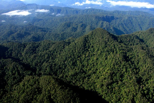
The Track: Your guide will know the route, camp sites and seasonal sources of water well, and anticipate time and distance to the next camp and when/where to set camp. Don’t underestimate the degree of difficulty of the track – much is through moss/cloud forest, climbing up/down/over tree roots, negotiating “floating floors” of moss and peat, scrambling under and over fallen trees, etc. Prickly rattan plants are a continuous bother. Perseverance and stamina are required.
Size of party and porters: we would advise that groups should not exceed four tents – camp space is often limited and, for every extra trekker, one or two additional porters may be required. Guide and porters also require tent/cooking space, which increases size of party and pressure on camp space. Discuss with your guide, in advance, whether you will carry your own heavy pack (or day pack only) so that porters can be arranged accordingly. Trekkers/porters should be prepared to share the load in the event of either being incapacitated.
Trekking Days: 12 days should be allocated for the trek: 5-6 days from Kedah to the Leuser range; 2-3 days on the Leuser range if your plan on climbing all three peaks; 3-4 days return to Kedah. Allow for delays due to rain (which are also opportunities for rest). The return trek normally takes less time because the trek is on average downhill, trekkers are fitter and loads much less.
Camp Sites: These are numerous providing some flexibility when and where to set camp in the event of bad weather. Most are limited to 4-5 tents including tents for guide/porters who have their pre-determined places near the fire for cooking and warmth. In the interests of safety, agreed names should always be used for all campsites. Names used in this report are as per brochure issued by the Gunung Leuser National Park and endorsed by Pak Jalli, Rainforest Lodge.
Distance and time between camps: the National Park brochure indicates distance between camps – a total distance from Kedah to Gunung Leuser of 50 kms (our GPS indicated approx. 60 kms). But, time between camps is a more useful guide because it takes account of terrain, etc. Times, reported below, are for medium-strong trekkers – the pace that porters would normally maintain including their frequent cigarette stops. (Note: e.g., 1:45 hrs = 1 hour and 45 minutes.)
Water: during wet periods, water is available at most camp sites often in soaks, a hole dug in the ground where surface water accumulates during rain (exceptions: Camps Simpang Air and Perpayi). Water in dry periods is more problematic – see below by campsite. As there is no human habitation in the mountains, water is generally uncontaminated. Boil or use disinfectant tablets if you have concerns.
Food: Our guide provided a basic diet of rice, mie and dried fish with onions and chilli for breakfast and dinner, and biscuits for lunch – plus tea and coffee. Foods such as muesli, dried fruits and nuts, freeze dried vegetables, cheese, Milo, etc are a welcome addition. Porters cook over open fires with a pot for rice and wok for mie, onions, chilli, etc. Your own small saucepan, mug and spoon will come in handy.
Contingency Planning: Ensure that your group has adequate medical supplies. Think through what you would do if a member sprained an ankle or worse, the need for your group to split up, or emergency evacuation by stretcher or helicopter. Consider carrying a satellite phone. Camp Padang Rumput (2,404 m) has been used as a base for helicopter SAR.
Overview of the Trek: The trek involves five stages corresponding to ridges traversed. Transferring from one ridge to another often involves steep descents/ascents. From Rain Forest Lodge, ascend via the Angkasan Ridge to Puncak Angkasan (2,916 m). Descend along the Kulit Manis (cinnamon) Ridge. Cross over onto Pepanyi Ridge following the upper reaches of the Alas River. Descend to and wade across the Alas River. Ascend and traverse the Bipak Ridge. After reaching the Krueng Kluet streams, climb up onto the Leuser Range.
Angkasan Ridge
Rain Forest Lodge (1,346 m): climb through local forest, tobacco fields and enter tall, dense lower-montane forest at the entrance to the National Park. About 100 m inside the Pintu Rimba, ‘entrance to the forest’, a path to the right leads to a campsite used by Rain Forest Lodge for wildlife tours; continue ahead – long, steep ascent (about 1,600 m) to Puncak Angkasan.
Camp Simpang Air (2,270 m; 2:30 hrs; poor campsite, no potable water in wet/dry season): enter upper-montane forest; trees diminishing in height and density.
Camp Bivak I (2,580 m; 1:30 hrs; reasonable campsite; 5-6 tents; no water in dry season); enter sub-alpine forest with moss forest in damp glades.
Puncak Angkasan (2,916 m; 2:45 hrs): peak marked by a cement trig point, T3356 (survey plague removed by ‘trophy-hunting’ trekkers!); short descend to ‘Angkasan Intersection’ where you can continue to Camp Angkasan (2,906 m; 0:15 hrs; good camp site; water) or, turn right and begin the descent of Kulit Manis Ridge.
Kulit Manis Ridge
Kulit Manis ridge is characterized by knolls of burnt, regenerating scrubs and heavy undergrowth with moss forest in deep depressions.
Camp Kulit Manis I (2,833 m; 1:00 hrs; 3-4 tents; no water in dry periods).
Camp Kulit Manis II (2,750 m.; 1:10 hrs; 4-5 tents; no water in dry periods). From here, the trail drops steeply down into moss forest before rising towards the hilltop of Kulit Manis III.
Camp Kulit Manis III (2,616 m; 1:15 hrs; 4-5 tents; no water in dry periods).
Pepanyi Ridge
The track now passes over to the Pepanyi Ridge. It drops steeply and enters moss forest with many trees/tree roots lying across the path before rising onto the Pepanyi ridge. This ridge follows the course of the upper reaches of the Alas River passing over two peaks, including Gunung Pepanyi (2,440 m). Most of the trek, until emerging into the open country at Camp Padang Rumput, is through heavy moss forest – laborious, uninteresting trekking! Tigers apparently frequent Pepanyi and have be seen unexpectedly! We did not see any tigers but did see their droppings.
Camp Lintas Badak (rhinoceros trail) (2,333 m; 1:30 hrs; 4-5 tents; water). This trail, and four others that are crossed on the Pepanyi ridge (still quite visible), were used by rhinoceros when moving between the Alas River and their feeding grounds to the north – until they were shot out for their horns and became extinct in the area in the early 1990s (info: Pak Jalli).
Camp Pepanyi (2,433 m; 1:45 hrs; 4-5 tents; no potable water in wet or dry periods). This camp site is in heavy moss forest, not comfortable, and should be avoided.
A welcome respite from the moss forest is a wonderful view of a waterfall on the Alas River, about 0:45 hrs from Camp Pepanyi.
After about another 1:45 hrs, climbing up and over Gunung Pepanyi, the ecology changes abruptly from dense moss forest to open, low alpine bush on shallow soils derived from sedimentary rock. This point is known as the Pintu Rimba, ‘entrance to the forest’; water.
Camp Padang Rumput (meadow) (2,404 m; 2:00 hrs; 4-5 tents; water from ‘soaks’). Porters favour this camp; open and relaxing, about half way through the trek, and offering first views of Leuser Range.
From here, the track descends to the Alas River across open country and small streams with Rhododendrons in humid depressions. Wade across the Alas that, at this point, is normally a small, fast-flowing stream. Caution: flash floods can occur – anticipate heavy rain in the upper reaches before crossing.
Camp Alas: (2,285 m; 1:00 hrs; 5-6 tents; pure mountain stream water); a very pleasant camp on the southern side of the Alas River.
The track now ascends gradually through open country and several humid depressions; several depressions are of particular interest for the many varieties of orchids dominating the vegetation.
Camp Rantau Panjang: (2,446 m; 1:00 hrs; 5-6 tents; no water in dry season). A pleasant, but exposed, campsite on a sloping grassy slope with views towards Leuser Range and back towards Puncak Angkasan.
Bipak Ridge
The trail now climbs steeply up onto the Bipak Ridge to alpine scrub dominated by rhododendron, magnolia, oak and other vegetation. The ridge comprises of a series of gentle knolls at around 2,900 m – pleasant trekking. The Bipak Ridge continues through Camp Putri to Camp Krueng Kluet.
Our guide informed that Bipak means place of rest; maybe, Bipak is a transliteration of “p” for “v”, i.e., bivak, derived from the French/English, bivouac.
Camp Kolam Badak (rhinoceros wallow); (2,733 m; 1:30 hrs; 3-4 tents; permanent waterhole). The tent area is not very flat. The waterhole is a reminder of the rhinoceros that used to inhabit the region. The track then passes over the highest point on the Bipak Range, Gunung Bipak III, (3,020 m).
Camp Bipak III (2,982 m; 2:10 hrs; 4-5 tents; no water). Good camp site, with great views. The ridge narrows and the track, in places, follow the edge of the steep escarpment overlooking the rugged country to the west coast. Take care. Spectacular views towards the west coast begin to emerge.
Camp Putri (2,940 m; 2:00 hrs; broad sloping area; 5-6 tents; water below). Great panoramic views of the Leuser Range and its peaks and of the terrain to the west coast. Fire wood is now exhausted – porters will wish to camp elsewhere.
After an initial steep ascent, the track involves numerous ascents of alpine scrub knolls and descents into moss forest depressions until reaching the Krueng Kluet streams. This part of the trek is strenuous but compensated by great views of the Leuser Range as it comes into closer view.
Camp Bipak Kaleng (2,940 m; 2:00 hrs; 4 tents); wet during rain; no water in dry periods.
Camp Bipak Batu (2,950 m; 1:30 hrs; water; 5-6 tents); good camp with great views. From here, the track descends to the two streams, Krueng (stream) Kluet-1 and 2.
Camp Krueng Kluet (on the second stream); (2,920 m; 1:30 hrs; 4 tents; pure mountain water).
Leuser Range
Camp Krueng Kluet marks the end of the extended Bipak Ridge. From here, the track climbs steeply up onto the Leuser Range; rather long and laborious!
Camp Simpang Puncak Tanpa Nama, literally, ‘intersection to the mountain without a name’ (3,211 m; 1:30 hrs; water nearby but difficult in dry periods; 4-5 tents); also known more simply as Camp Simpang Tiga (T-junction).
The track divides here: the left track leads to Gunung Tanpa Nama; the track ahead leads onwards to Gunungs Loser and Leuser.
The true summit of Gunung Tanpa Nama (3,466 m) is reached through alpine scrub and meadows; an easy climb but, as few trekkers seek to climb this peak, the track is ill-defined and a guide who knows the track would be useful to navigate the scrub but not essential as the route to the peak is obvious.
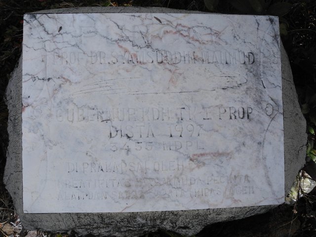
The mountain has two knolls: a painted sign on the lower knoll (3,455 m) reads “Puncak Tanpa Nama” (summit of Mount ‘Tanpa Nama’). On the higher, more prominent knoll to the north-east, the true summit, a plague embedded in a cement block reads, “Prof Dr Syamsuddin Mahmud, Governor Aceh, 1977 …” The trek to the lower knoll takes about 1:15 hrs and another 0:45 hrs to the true summit.
Camp Lapangan Bola (football field); (3,130 m; 1:15 hrs; 4-5 tents; water). This is a dry, sloping ridge above marshy swamps that can be very boggy after persistent rain.
Gunung Loser is climbed from here along a well-used track. Cairns of rocks guide trekkers to the summit over ill-defined parts of the track during heavy cloud.
Camp Summit Loser (3,404; 1:30 hrs; one tent at the trig point; water below; no firewood). A camp at the summit offers the possibility of spectacular sunset and sunrise views. Otherwise, camp somewhere below the summit (4-5 tents; closer to water; limited firewood) and return to the summit for sunset and sunrise.
Gunung Leuser (3,119 m) is reached from Gunung Loser via the escarpment between the two peaks; about 1:45 hrs. Caution: in places the track overhangs the precipitous cliffs dropping down to the west coast. The track is not well defined as, it seems, few trekkers seek to climb Leuser.
Camp Danau (lake) Leuser lies below the final ascent of Gunung Leuser; a delightful little waterhole especially if you wish to see the sunset/rise from Leuser.
The return trek from Leuser to Loser takes more time as Leuser is some 250 m lower than Loser. A trek from Camp Lapangan Bola to Gunungs Loser and Leuser and return in one day is strenuous even for stronger trekkers. Better to camp at Loser, if time and weather permit, and make the trek to Leuser from there.
Information by Nicholas Hughes and Alfred Fahringer (August 2014)
TERIMA KASIH ATAS KUNJUNGAN ANDA

That is pretty much you discussed.
so much environmental issues to discuss ... thanks for the suggestion.
penjelasan yang sangat rinci tentang pendakian gunung....