Europe-Asia (featuring Vasily Peskov as author)
Europe and Asia meet on this forest clearing. One fir tree grows in Europe, the other, within sight of it, in Asia. A flock of waxwings rises from an ash-berry tree, circles over the clearing and settles on a mountain ash in Asia. The people in the clearing, feeling chilled, run back and forth between Europe and Asia. A bus stops. The passengers read the words "Europe-Asia" on the stone marker, draw a line on the pavement and jump across it into Asia, with everyone enjoying the fun.
Two great continents meet along the Ural Mountain range, facing each other across the Ural River. In some places the border passes between neighboring villages. When visiting the city of Magnitogorsk you spend the day on the right bank of the Ural River and then take a streetcar to your hotel in Asia. Though the border is of no actual significance in everyday life, there is something solemn about crossing the line the first time. Thousands of kilometers lie behind you. Ahead are the frost-tinted crests of the dark forests, yet more thousands of kilometers of your native land stretching endlessly before you. At a moment like-this you have a physical sensation of your country's vastness.
Has the border between the two great continents always passed here? A search in the library will tell you that in the 5th century В. C. Herodotus drew the line along the Bosporus, the Black Sea, the Sea of Azov and the Don River. The Greeks had no knowledge of the lands that lay to the north of the Don. In the 17th century the line was drawn along the Don, the Volga, the Pechora and the Kama rivers. Guillaume, a French traveller, extended the borders of Europe as far as the Ob River on his map of 1760. However, his knowledge of the Eastern territories was so limited that he did not indicate the Ural Mountains, for he simply did not know they existed. Alexander Humboldt, the German scientist, suggested that Europe and Asia be considered as a single continent to be known as Eurasia.
Vasily Tatishchev, an 18th century Russian geographer, was the first to draw the border along the Ural Mountains. This fine scholar had a first-hand knowledge of his country. He noted that the rivers of the Urals flow in two directions: some discharge their waters into the Pechora and the Kama rivers, while others flow into the Ob. He was to write: "On the Western side the fish in the rivers have red flesh. These are the salmon and grayling. The fish in the Eastern rivers, though in appearance similar to those in the Western rivers, are the white salmon, salmon-trout and muksun, all of which have white flesh and a different taste." He also noted the difference in plant life beyond the mountain range. "These and similar observations make it possible to state that the mountains are a borderline between Asia and Europe." Tatishchev was also the first to name the range the Ural Mountains. Tatishchev adopted the local Tatar name, for "ural" means "belt" or "stone belt".
Thus was the border determined once and for all. Travellers today will note the markers in various places. They were set up at different times. In one place this is a cast-iron structure resembling a church, in another it is an iron pyramid, in a third it is a post with a lantern and the warning that one is approaching Asia. There is a very recent post supporting a globe and several small sputniks. t^lo one has ever counted the markers, but I believe there are seven. However, there may be more, fc>r the border begins beyond the Arctic Circle and reaches down to the Caspian Sea, with new markers appearing every now and then. One such project was being discussed when I was in Magnitogorsk.

People have always had a weakness for drawing symbolic lines across the globe. When flying over the Equator the pilot will dip his wings and each passenger will be presented with an ornate diploma testifying to the fact that he has seen "the middle of the Earth". The American polar explorers at Mac Murdo in the Antarctic presented us with special diplomas stating that we had crossed the Arctic Circle. However, so many people travel back and forth between Europe and Asia these days that diplomas or commemorative pins are probably out of the question. And yet, why not put out some small souvenir as a remembrance of the occasion?
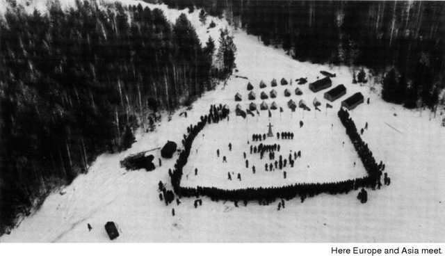
Hikers have found this borderline an excellent place for meets and for the festival that was originated here. It all began when a hiking group in Moscow started corresponding with a similar group in Sverdlovsk. They finally agreed to meet at the border marker located forty kilometers from Sverdlovsk. This meeting turned into such a lively and interesting event that for the past twenty years hikers have gathered here each year on the first Sunday of February. They come from Moscow, the Urals, the Baltic Republics, the Kamchatka Peninsula, the Caucasus, Syktyvkar, Murmansk, Voronezh, Omsk and Krasnoyarsk. People from all over the country.
On the Sunday I was there close to a thousand hikers lit the huge ceremonial bonfire. Never before had I seen such a joyous and busy "hikers' fair". People were exchanging souvenirs, pins and hiking maps. There were songfests, new acquaintances were made as well as plans for meeting again the following summer. Nearly all of the groups then went off on winter hikes in the mountains.
This is the border. From the mountain-top you look out at the land that is yours. A plane leaves a white trail in the sky. A blue haze from some stacks rises over the forests in the distance. There is a cliff, a strip of river. And farther on some more smoke, or perhaps frosty vapors rising from the earth. The mountain range of rock and iron ore densely covered with forests stretches on for a thousand kilometers. To the left and right lie the two outspread wings of our country: Europe and Asia.