Spectacular Hawaii's Kilauea volcano - Full HD - Video selection
What's Going On With the Volcano?
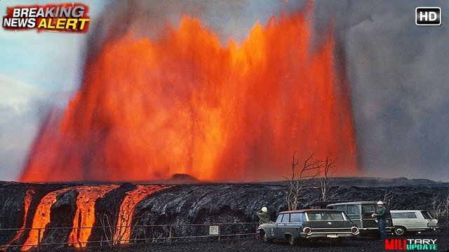
Vigorous eruption of lava continues from the lower East Rift Zone (LERZ) fissure system in the area of Leilani Estates and Lanipuna Gardens.
Visual observations early Tuesday morning also confirmed continued weak activity at Fissures 18, 19, and 20. Fissure 18 has produced channelized flows which have advanced about one-third of the way (1.2 mi) toward the coast.
Pele's hair and and other lightweight volcanic glass from high fountaining of Fissure 8 are being transported downwind and falling to the west of the fissure. On Monday night, there were reports of Pele's hair falling in Pāhoa. Residents are urged to minimize exposure to these volcanic particles, which can cause skin and eye irritation similar to volcanic ash.
The most recent map of lava flows can be found here: https://volcanoes.usgs.gov/volcanoes/...
HVO field crews are on site tracking the fountains, lava flows, and spattering from multiple fissures as conditions allow and reporting information to Hawaii County Civil Defense. Crews are also checking on the status of ground cracks on Highway 130.
Volcanic gas emissions remain very high from the fissure eruptions. Trade winds are weakening, and widespread vog is expected on the Island of Hawaii on Monday.
Magma continues to be supplied to the lower East Rift Zone. Earthquake locations have not moved farther downrift in the past few days and the number of located earthquakes remains low.
Additional ground cracking and outbreaks of lava in the area of the active fissures are possible. Residents downslope of the region of fissures should heed all Hawaii County Civil Defense messages and warnings.
USGS/HVO continues to monitor the lower East Rift Zone activity 24/7 in coordination with Hawaii County Civil Defense.
Kīlauea Volcano Summit
Ash continued to erupt intermittently from the vent within Halemaʻumaʻu crater, at Kīlauea's summit. At 1:56 AM HST, there was a small explosion that sent ash to 15,000' above sea level. The ash cloud rose vertically above the summit and drifted only slightly to the northwest owing to calm winds. The explosion was reported felt by a number of residents in the Volcano area, and it resulted in the emplacement of some incandescent blocks on the east floor/wall of Halemaʻumaʻu crater.
Additional explosive events that could produce minor amounts of ash fall downwind are possible at any time. Volcanic gas emissions at the summit remain high.
For forecasts of where ash would fall if such an explosion occur, please consult the Ash3D model output here: https://volcanoes.usgs.gov/observator...
Information on ash hazards and how to prepare for ashfall maybe found here: http://www.ivhhn.org/information#ash
Kīlauea East Rift Zone Fissures and Flows
Map Courtesy USGS - Hawaiian Volcano Observatory
Kīlauea Lower East Rift Zone Fissures and Flows, May 28, 3:00 p.m. HST
Given the dynamic nature of Kīlauea's lower East Rift Zone eruption, with changing vent locations, fissures starting and stopping, and varying rates of lava effusion, map details shown here are accurate as of the date/time noted—and could have changed rapidly since that time. Shaded purple areas indicate lava flows erupted in 1840, 1955, 1960, and 2014-2015.