The Niger—A River That Feeds Many Nations
TO A traveler in a low-flying aircraft, the Niger River appears like a broad ribbon woven intricately into the contours of West Africa. Its rapids and waterfalls seem like delicate frills of white lace adorning the ribbon, and the tributaries like slender streamers of green, gray and brown.
But to the five nations whose land it drains and waters, and the more than 20 tribes who feed and make a living from its waters, the Niger is far more than an adornment. It is essential to their very existence.
There are schemes for its increased use. Nigeria has projects to develop river transportation far beyond what exists at present. There are river basin development projects to increase irrigation for agriculture and livestock. In these and other ways, the people of Nigeria, Niger Republic, Mali and, to a lesser extent, Guinea, the Republic of Benin, and even Cameroon look to the Niger for even greater advantages in the future. This is the outgrowth of a development that started some two hundred years ago.
Opening the River
Throughout the centuries, the local peoples, merchants and explorers made use of the river in a number of locations. Yet, until the 19th century, no one succeeded in tracing it all the way to its source.
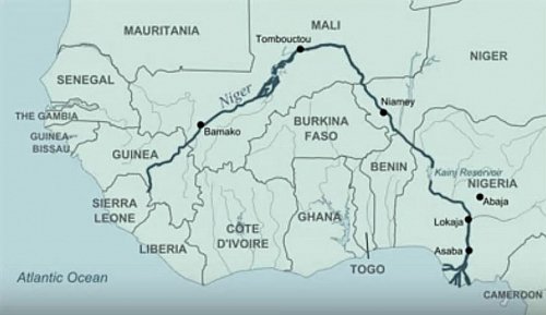
By the end of the 18th century, it had been established that the river had its source in the highlands of Guinea, only 360 km (220 mi.) from the Atlantic coast, and that from there it flowed inland. Early explorers followed its northeastward course through lush tropical forests of Guinea to Timbuktu. They found that it continued east and southward in a wide loop across vast stretches of savanna and the arid sand dunes of the southern Sahara. This led geographers to wonder if it was a tributary of the Nile or of the Congo. Some thought it was the Congo itself.
After several expeditions, explorers finally followed the entire course of the river right to its outlet to the sea. They discovered that, after flowing for 4,200 km (2,600 mi.), the Niger enters the Atlantic Ocean through a bewildering maze of creeks that form its delta in the Gulf of Guinea, a mere 1,700 km (1,000 mi.) from its source.
Following this discovery in 1834, the entire course was properly charted and opened up for use by foreign merchants. The Niger now began to take on an importance far beyond the limited use to which it had been put by the local peoples. Up until then they had employed it for only small-boat transportation, fishing, and agricultural and domestic water supply.
Major Inland Waterway
By the year 1878, four British companies were operating on the river, carrying commercial shipping vessels far inland. Comparatively large steamers of that time navigated some 670 km (400 mi.) upstream to Lokoja at the Niger/Benue confluence. The Benue tributary is now navigable during the rainy season from the confluence for most of its 1,400-km (870-mi.) course eastward to Garoua in the Cameroon Republic. However, the draft of vessels that can navigate these distances varies seasonally with the volume of water in the rivers.
The river traffic contributed to the development of a timber industry and extensive oil palm and rubber plantations in Nigeria. It also provided a comparatively easy and cheap outlet for other exportable agricultural produce from the northern hinterland, and the bringing in of imported materials.
Due to growing demands for cheap transportation, plans are under way to make full use of the great transportation potential of the Niger/Benue river system. Annual transportation demands are expected to increase from the present 1.5 million tons to more than 6 million tons by 1985. To meet this demand, there are projects to improve the navigability of the system and to provide adequate river ports and places for efficient handling of freight.
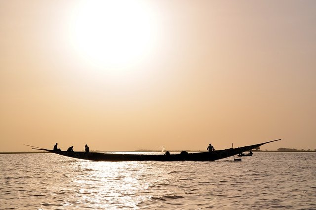
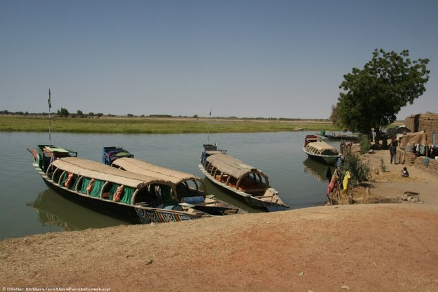
The shallower waters in the desert plains of Mali and the Niger Republic can only accommodate vessels of shallow draft. Still this section of the river carries a fair amount of traffic in the form of small fishing and trading boats and canoes. Fishing and farming are important activities here, especially in the unusual inland delta region.
The Inland Delta
During the rainy season, the Niger is fed by heavy rains in the highlands of Guinea and gradually swells to flood the flatlands of Mali. The floodwaters spread out in numerous meandering streams and lagoons. The land soaks up the water and stores it in sodden marshes to form this “inland delta.” This freshwater marshland covers an area 34 km (20 mi.) wide and 425 km (260 mi.) long, with the northern limit at Timbuktu. Gold particles washed down from the highlands by the river helped to make that city wealthy and famous in the Middle Ages. Although panning for gold is now of negligible importance, the waters still provide good irrigation and excellent fishing grounds.
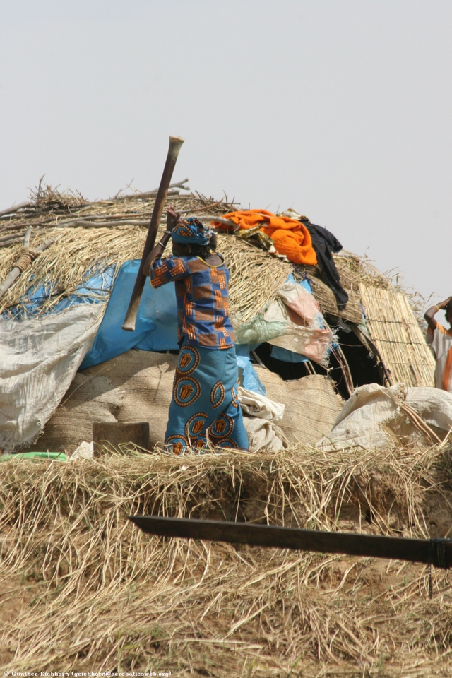
image credit
Rich rice fields flourish there in the marshlands. The overflow of water during the flood season provides natural irrigation for the fields of other grains, like millet and sorghum. Yet canals such as those being used in Nigeria are not employed here. Water is carried in bowls made of skin, or in other containers, to fields that are beyond the marshlands. Attempts to introduce modern irrigation were hampered by centuries-old agreements on land and water ownership. Furthermore, distribution of water by canals increases the risk of spreading waterborne parasites.
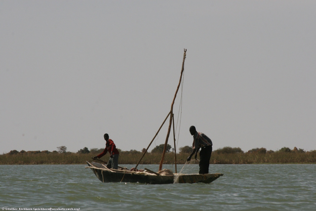
Fishing Grounds
Fishing is a major occupation. During the flood season fish, like the large capitaine, or Nile perch, leave the main streams of the river and spawn in the marshes. When the waters recede during December to March, the fattened fish are left to flounder in the shallow waters. It is then easy for fishermen to pick them up or to catch them in enormous numbers in their traps.
Of course, it is not only in this inland delta that the river supports a thriving fishing industry, just as it is not only here that the river is vital to the survival of plantations and cattle. All along the course of the Niger fishing is an important occupation of the people. However, the Kainji Dam at New Bussa in Nigeria is outstanding in the development of the fishing industry. The primary purpose of building the dam was to provide a constant water supply to feed the huge Kainji hydroelectric plant that supplies electricity to Nigeria and the Niger Republic. As anticipated, this artificial lake, which covers nearly 1,300 km2 (500 square miles) has become a major fishing ground. A similar project is now proposed near Lokoja, southeast of Kainji. This would provide for another large hydroelectric dam and create a large lake with potentially rich fishing grounds.
The Coastal Delta
Where the river loses itself in the most complex delta system in Africa, once-remote towns and villages are taking on importance. This is an oil-rich area, yielding petroleum in quantities that have placed Nigeria among the world’s top 10 producers. As a result, people in this area inaccurately speak of oil as the river’s second liquid gift.
Among the network of creeks, the Ijaw-speaking people virtually live in the water. The creeks are their roads and the canoes are their cars. As with the people of the inland delta, fishing is their chief occupation. When the men bring in large supplies of fish that have been caught in basketlike traps, the expert oarswomen take to their canoes. They become the “fish women,” bringing fish to waterside markets or to people who live in the houses that rise out of the water on long stilts.
This is also an area where the raffia palm grows in profusion and is rated as very valuable. It provides the people with material for building houses and for making brooms and mats. As a bonus, a local gin is distilled from the sap drawn from the heart of the tree. It is no wonder that when the oil companies buy swampland, they pay dearly for the trees as well.
So the Niger is indeed a river to which people look for a living. It quenches the thirst of the parched ground and adds a ribbon of beauty to the arid land. Development projects aim to establish it even more firmly as important to the economic growth of the nations through whose territory it flows.
SAHARA
Timbuktu
MALI
Bamako
Niamey
NIGER
GUINEA
BENIN
Kainji Dam
NIGERIA
Garoua
CAMEROON
Niger River
R. Benue
Niger Delta
Gulf of Guinea
Equator
Niger
Congo
Nile
AFRICA

Dear friend, you do not appear to be following @wafrica. Follow @wafrica to get a valuable upvote on your quality post!
Done
You received a 10.0% upvote since you are not yet a member of geopolis and wrote in the category of "history".
To read more about us and what we do, click here.
https://steemit.com/geopolis/@geopolis/geopolis-the-community-for-global-sciences-update-4
Very detailed and well articulated post @freshenstine... I am amazed at the path taken by Niger river, rather unusual I must say... It was a good read...
Thanks alot
Awesome post!!! Great choices in images too. Thanks for sharing.
Great post!