My Faults: A Journey Along the Pacific and North American Plates, Part 2 of 3 (Cascadia and San Andreas North)
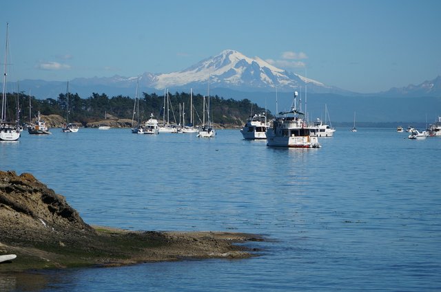
This is Part 2 of 3 in a series of posts. If you have not yet read the previous part, please find it in my blog. Previously, we looked at the northern section of the fault lines that separate the Pacific and North American tectonic plates. Now in Part 2, continuing south, we cover the Casacadia subduction zone and the northern portion of the San Andreas fault. The picture above shows a port in Washington state with one of the volcanic Cascades mountain peaks behind it.
The Mighty Cascadia Subduction Zone
Starting around this junction, there are some plate fragments far beneath the surface. The Explorer Plate, San Juan de Fuca Plate, and Gorda plate are three smaller ones that straddle this section of the Pacific-North American Plate boundary. This creates more possibilities for subduction, which is where one plate slips beneath another. Subduction can cause violent earth movement and is often associated with volcanoes nearby, as we see along the Cascade Mountains in the Pacific Northwest.
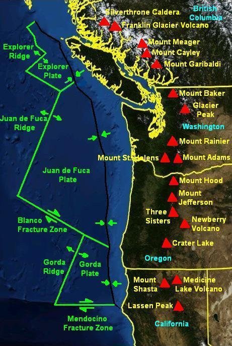
The volcanoes of the Cascades stretch from British Colombia straight down through Washington, Oregon, and Northern California. Volcanoes include the Silverthrone Caldera, Mt. Meager, and Mt. Garibaldi in British Colombia; Mt. Baker, Mt. Rainier, Mt. St. Helens, and Mt. Adams in Washington; Mt. Hood, the Three Sisters, Crater Lake (a collapsed volcano), and Mt. McLoughlin in Oregon; and Mt. Shasta and Lassen in California. It is a relatively straight North-South line of mountains because the plates to the west are sliding beneath the North American plate.
Most, if not all, of these mountains remain active volcanoes. The most famous of them may be Mt. St. Helens, which had a major eruption in 1980 that killed 57 people and created a swath of destruction. The mountain blew a 1-mile wide crater in an eruption that reduced the elevation of its summit by some 1300 feet. But Mt. St. Helens is just one of these peaks, each of which remains an active volcano. Some, such as Mt. Rainier and Mt. Hood, are close to population centers in Seattle and Portland.
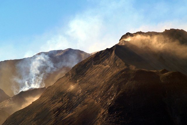
Mount St. Helens in southern Washington, which erupted in a major blast in 1980.
The volcanoes parallel a dangerous Cascadia fault line
From Vancouver Island all the way to the top of northern California, there is a very troubling segment of the big crack. We have reached a fault called the Cascadia subduction zone and it may be the most dangerous part of the plate boundary in the lower 48 states. What makes it dangerous is the combination of populated cities + potential for catastrophic earthquakes. While Los Angeles and San Francisco sit right near faults to the south and get more attention, the Cascadia Fault is capable of larger earthquakes. That’s because one plate is slipping underneath another, as in the Aleutian zone, and as in the faults off Japan and Indonesia. It's a more violent action that sliding in parallel.
.jpg)
Source: USGS.
Even a decade or two ago, scientists did not think that the Northwestern United States was in danger of major earthquakes. There simply hadn’t been much activity on the Cascadia Fault during recorded history. But many of these same scientists also did not think that the fault in Japan was capable of enormous earthquakes either. Then came the 2011 Tohoku earthquake (9.0-9.1 in magnitude) and tsunami that devastated parts of Japan. Scientists realized that such earthquakes could happen, and that the timeline they had been looking at was too recent to spot the historical pattern.
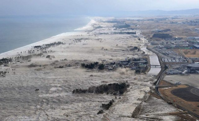
The tsunami from the 2011 Tohoku earthquake in Japan, which struck on a fault which is similar to the Cascadia fault lying off the coasts of British Columbia, Washington, Oregon, and the northern part of California. Source: AP.com
Scientists had been looking back in the geologic record, but looking at decades rather than centuries. They hadn’t searched far enough back to spot the evidence that these large and rare quakes leave. For example, such evidence includes tsunamis that deposited layers of sediment far inland and uphill. These layers can be dated. And when scientists had the same sinking feeling in the Cascadia zone (a mirror image of Japan’s fault), they began looking further backward in the evidence that had been left in British Colombia, Washington, Oregon, and northern California.
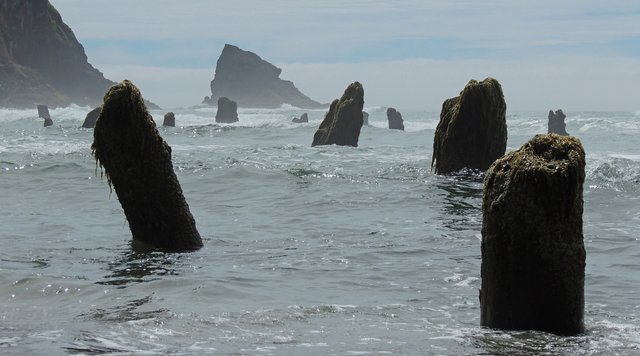
The ghost stumps. Once upon a time, there was a forest here, but the entire coastline dropped in elevation. Creative Commons via Flickr.com by Wolfram Burner.
They looked at layers in hillsides and in the mud banks of nearby rivers in Oregon and Washington. They studied tree rings and carbon-dated the ghost forests of Sitka spruce tree stumps and logs that still stand (even today in several locations) beneath the ocean’s surface except at low tide. This evidence pointed to a rapid elevation drop for the coastline from southern Washington all the way to northern California. And what they found was a perfect match for Native American oral traditions (which spoke of a tremendous shaking and flooding), and for corroborating stories of a mystery tsunami that hit Japan (apparently from across the ocean, since there had been no local earthquake there).
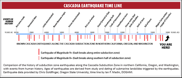
Source: Oregon Department of Geology and Mineral Industries.
The evidence showed that the Cascadia fault had produced a huge earthquake in the year 1700 (estimated at 8.7-9.2 magnitude) and it was part of a pattern of large quakes/tsunamis that were separated by centuries, not decades. This fault does go off regularly, but simply hasn’t done so since well before Lewis and Clark reached Fort Clatstop, Oregon on their voyage of discovery.
Bottom line: scientists now believe that the Cascadia fault off the Pacific Northwest is very dangerous, prone to large and rare earthquakes. Not only is it linked to a string of active volcanoes, but the fact that it has been relatively quiet for a long period should not be cause for calm, but for a heightened sense of alert. The general low level of activity on this fault might mean that it is locked tightly. Cascadia may be heavily pregnant and ready to roll.
San Andreas North
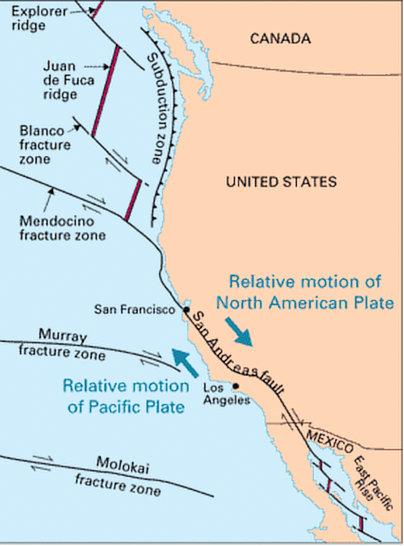
There is some splintering of the fault lines around Cape Mendocino in northern California, after which the line picks up again. This region is home to another triple junction where the North American, Pacific, and smaller Gorda Plates come together, creating more possibilities for geologic unrest. From there, heading south, the boundary between Pacific and North American Plates takes on a new name: the San Andreas Fault, probably the most famous fault line in the United States. (Yes, there are movies and video games named after it also, but probably much less realistic.)
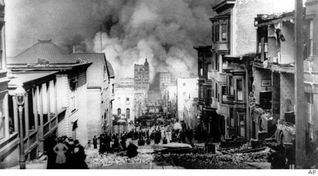
The San Andreas produced the 1906 earthquake (7.9 magnitude) that devastated San Francisco. The 1906 quake had its epicenter at Mussel Rock, on the coast just south of the city, but for a long time people believed it was focused further north because there was so much land movement at Olema near Point Reyes. Point Reyes is a strange feature because, aside from being a beautiful park, it is a peninsula that sits on the Pacific Plate, cross the San Andreas fault from the rest of the mainland. While North American is moving roughly to the south, the Pacific Plate here slips northward. In about 28 million years, if current tectonic trends continue, scientists say that Pt. Reyes will have slid all the way up to Alaska!
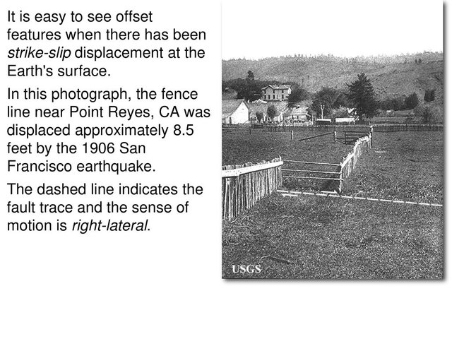
From the following park map of Point Reyes National Seashore (which is centered on the coastline north of San Francisco), you can see how this finger of land, even now, seems separated by this fault from the mainland. There is a hiking trail at the park you can visit which shows some of the land's movement from the 1906 earthquake. One particular fence line broke and you can see where one side of it moved several yards away.
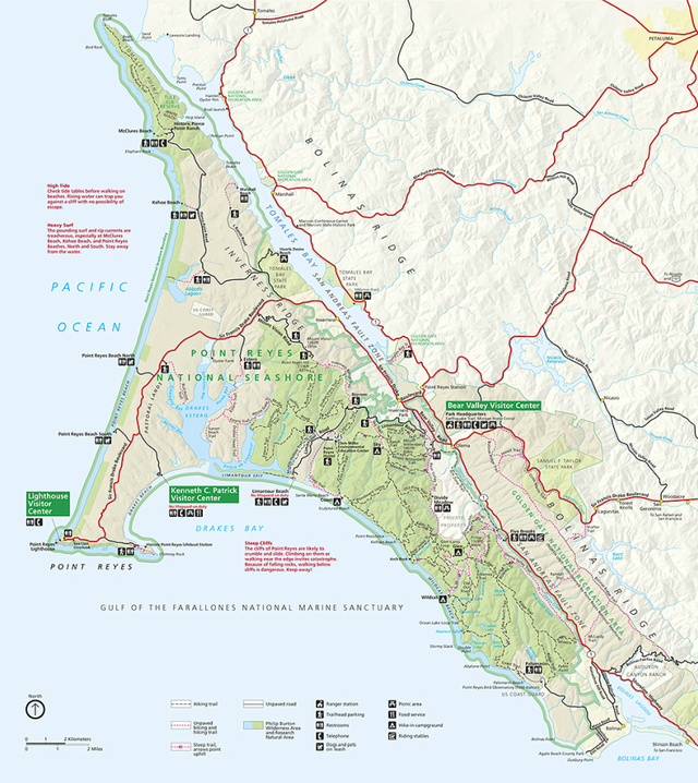
Source: National Parks Service.
Source: USGS.
The fault barely touches San Francisco, running through the ocean west of the Golden Gate. Some of the people who witnessed the 1906 earthquake saw the motion coming right through the city, though. It was said to look like a zipper coming up the hilly streets. The 1989 Loma Prieta quake also inflicted some damage in San Francisco, but not on a scale with the earthquake and resulting fires of 1906.
South of San Francisco, the crack moves onshore again. If you drive south down Highway 280, you can see the reservoirs to the west (San Andreas and Crystal Springs), which are right on top of the fault. It then moves into the Santa Cruz Mountains, passing quite near Loma Prieta where the 1989 earthquake occurred.
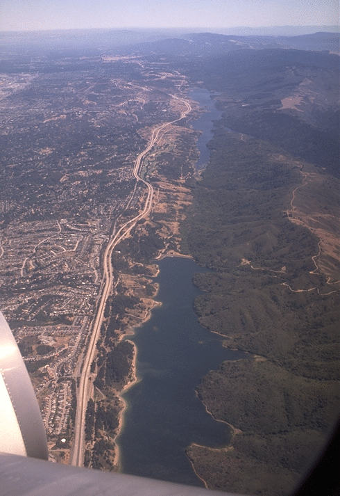
Crystal Springs reservoirs, south of San Francisco. Can you see the fault line? It runs right beneath the water there and along Highway 280. Source: http://sepwww.stanford.edu/oldsep/joe/fault_images/BayAreaSanAndreasFault.html
The 1989 Loma Prieta (6.9) and the 1994 Northridge (6.7) earthquakes were on regional faults that are connected to the San Andreas system, essentially cracks that parallel it or splinter nearby. I was near San Francisco in 1989 and felt that one quite strongly. Another example of a regional fault is the Hayward Fault (part of a longer crack that connects with Rogers Creek in the north and Calaveras further south) The Hayward Fault runs parallel to the San Andreas, down the eastern side of San Francisco Bay. In 1868, it produced a 7.0 earthquake and may be primed for another one in the not-too-distant future.
Both the San Francisco Bay Area and the greater Los Angeles metropolitan area sit right near the San Andreas Fault. It will rumble again and it will cause more damage. Due to larger and denser populations, the damage today in either of these regions will be much greater than it was in 1906.
And yet, because the San Andreas Fault is a strike-slip where the plates run parallel to one another, scientists believe it is not capable of generating the mega-quakes that we have seen from subduction zones such as those off Japan and Sumatra. When the Cascadia fault pops to the north, for example, it could produce a much more intense quake, potentially with even more devastating impacts on cities like Vancouver, Victoria, Seattle, and Portland.
Stricter building codes and public education help. Wherever earthquakes strike in the future, it is best to be prepared. And hopefully, some of the worst impacts can be avoided with proper preparation.
This was Part 2 of 3. Please continue reading when the next segment is published!
References for all three parts. Unless otherwise indicated, all images are public domain or produced by a U.S. government agency and not subject to copyright:
Winchester, Simon. A Crack in the Edge of the World: America and the Great California Earthquake of 1906 (HarperCollins 2013)
https://en.wikipedia.org/wiki/Aleutian_subduction_zone
https://en.wikipedia.org/wiki/1964_Alaska_earthquake
https://en.wikipedia.org/wiki/Cascadia_subduction_zone
https://en.wikipedia.org/wiki/Cascade_Range
https://www.newyorker.com/magazine/2015/07/20/the-really-big-one
https://www.opb.org/news/series/unprepared/jan-26-1700-how-scientists-know-when-the-last-big-earthquake-happened-here/
https://en.wikipedia.org/wiki/2012_Haida_Gwaii_earthquake
https://en.wikipedia.org/wiki/1700_Cascadia_earthquake
https://en.wikipedia.org/wiki/Mendocino_Triple_Junction
https://en.wikipedia.org/wiki/San_Andreas_Fault
https://en.wikipedia.org/wiki/1989_Loma_Prieta_earthquake
https://en.wikipedia.org/wiki/1994_Northridge_earthquake
https://en.wikipedia.org/wiki/1857_Fort_Tejon_earthquake
https://en.wikipedia.org/wiki/1986_North_Palm_Springs_earthquake
https://en.wikipedia.org/wiki/Brawley_Seismic_Zone
https://en.wikipedia.org/wiki/Salton_Trough
Beautiful landscape, fascinating factoids, and one mistake: "beneath the ocean’s surface except at high tide."
You mean "except at low tide", I think. Either that or that they poke above the surface except at high tide.
If you visit Los Angeles to explore the San Andreas, let me know. We'd be happy to host you and show you our favorite historical sites.
Posted using Partiko Android
Thanks for the fix and for the comment!
I can't believe that some nations and land are sitting on a nature's time bomb this way, it's scarier than what you wrote and I have to check the previous ones too.
Not forgetting that every nations and land with there problem. I've never seen or beard an earthquake near me.
They don't occur everywhere, but over time, they will hit regularly along these faults.
I live in one of the cities considered as a red zone because of the tectonic place also because of the age of the formed Lands in Turkey the earthquakes are pretty usual here the affects are quite destructive in most of the 3rd world countries because the taxes that got collected to for funding earthquakes never getting used for disasters , goverment just says we can't guess when will it happen and spends it thats why I hate pool systems :D
It's a common issue in a lot of places. Stay safe.
I dont really know why but i just deteat vocano, maybe it's because of every moment hot or the flames it shows from afar I don't know
This post is educational, don't know it even exist in the locations you mentioned. Thanks much!
Brother, how are you? In fact, a very interesting topic that catches the attention of the reader, I have heard a lot about the San Andres fault, and people often say that it has been accumulating seismic activity during these years, and could cause a big earthquake. Although of course you can not know exactly how and when it will be, greetings from Venezuela,
You must have had a great time journeying through the Pacific plates and North America.
The map is quite sophisticated.
This post is worth a curie upvote, nicely done.
Remember I was telling from your last post about a movie :San Andreas?
I had to tell my sister that it was actually real and inspired by true events, Ikso showed her your blog post. I just have to re-watch the movie again from an educative point of view.
You mention where a fault line passes through the water table, oh my, what if it passes through an underground military facility.
The movie is fanciful; it imagines a larger quake than is probably possible on that particular fault. But entertaining and if it helps people in the region realize they should be prepared, that's fine.
Hello Friend how are you? I really want to thank you for exploring this topic that surely many are not aware of the natural time bombs that can explode at any moment, I had the opportunity to see The Fault of San Andres with the actor, dwayne johnson and I was very surprised, thanks to your posts I know about other tectonic plates, the scientists are alert but for me only nature knows exactly what can happen.
A lot more areas than I imagined are in danger of Natural disasters as a whole. Particularly Earthquakes, despite the studies and historical trends they just seem to unpredictable to me
They are unpredictable, but in some places, it's predictable that they will occur.
Please help this Blue Baby Patient, Laine Kharece by upvoting the link below. This is not a scam, we just need your support as part of steemit community. Thank you very much for reading and extending a little help.

https://steemit.com/upfundme/@wews/steemit-help-a-blue-baby-patient
Predictable unpredictability, like known unknowns, can be prepared for, just not prevented.
Posted using Partiko Android
Even though I live in kind of meh country I'm very grateful that I'm not near such dangerous tectonic plates, especially after seeing the pictures.
There's something just about everywhere (droughts, tornadoes, floods, etc.), but not quite everywhere. :)
I live on a hill in a temperate climate so floods and tornadoes are very unlikely :)